Northeast besieged by monster snowstorm

Friday, February 8, 2013
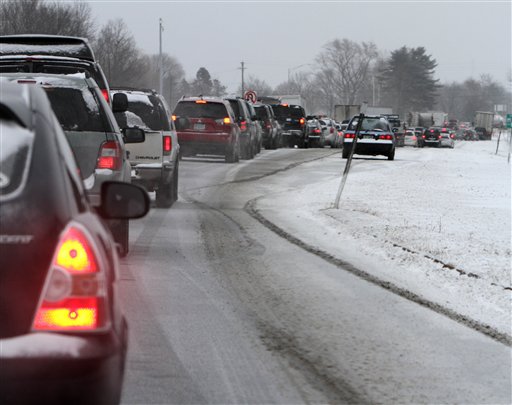 Cars are stuck Friday in traffic as a winter storm arrives in Newington, N.H. Snow began to fall around the Northeast on Friday at the start of what's predicted to be a massive, possibly historic blizzard, and residents scurried to stock up on food and supplies ahead of the storm.
A mammoth storm battered the Northeast on Friday with stinging wind and snow - possibly up to 3 feet in some spots.
Forecasters said wind gusts of 75 mph could cause widespread power outages and whip the snow into fearsome drifts. Flooding was expected along coastal areas still recovering from Superstorm Sandy.
•••
Here's a collection of images of people coping with the severe weather.
A look at effects in states and provinces in the path of the storm sweeping across the Northeast and southern Canada:
CONNECTICUT
Gov. Dannel P. Malloy imposed a travel ban Friday on the state's highways and deployed National Guard troops around the state for rescues or other emergencies.
A coastal flood warning was posted for southern Fairfield County, saying Friday evening's high tide could be 3 to 5 feet higher than normal in western Long Island Sound.
The state's two biggest utilities planned for the possibility that up to 30 percent of their customers - more than 400,000 homes and businesses - would lose power. As of Friday night, more than 30,000 had no service.
Nonessential state workers were ordered to stay home Friday. Schools, colleges and state courthouses were also closed. All flights after 1:30 p.m. at Bradley Airport near Hartford were canceled. Connecticut Transit ceased all bus service by 6 p.m. Friday.
Some gas stations ran out of fuel Thursday night during the rush to prepare for the storm.
MAINE
State offices closed early Friday as the storm that contributed to a 19-car pileup in Cumberland that took four hours to clear.
Registration and practice runs for the National Toboggan Championships were held Friday as scheduled, but Saturday's races were postponed for a day.
Up to 2 feet of snow was forecast along the southern coast, with lesser amounts across the rest of the state.
MASSACHUSETTS
Forecasters said the storm could top Boston's record of 27.6 inches, set in 2003.
Gov. Deval Patrick declared a state of emergency and ordered a statewide travel ban, believed to be the first since the blizzard of 1978.
Emergency management officials reported 320,000 utility customers without power Friday night, while Boston's transit system was shut down along with Logan Airport. Flights were expected to resume Saturday afternoon.
The Steamship Authority suspended all ferry service between Nantucket and Hyannis and between Martha's Vineyard and Woods Hole.
On Cape Cod, shelters opened at high schools in Sandwich, South Yarmouth, Eastham and Falmouth after a flood warning was issued; as much as 2 feet of snow is expected.
Harvard University's Hasty Pudding roast for Golden Globe-winning actor Keifer Sutherland took place Friday evening in Cambridge despite the storm.
NEW HAMPSHIRE
A blizzard warning is in effect through 4 p.m. Saturday for portions of the state. Gov. Maggie Hassan declared a state of emergency but stopped short of ordering everyone off the roads.
Hundreds of schools were closed Friday, airlines canceled flights and sporting and civic events were postponed. A storm-related crash in Auburn killed a man who lost control of his vehicle and hit a tree, fire officials said.
State-run liquor stores were slated to close at 6 p.m. Friday to encourage people to get off the roads by 7 p.m., when the storm is supposed to intensify.
Backcountry hikers were of high-mountain whiteout conditions and 80 to 90 mph gusts.
NEW JERSEY
A blizzard warning for northeast New Jersey called for as much as 14 inches of snow. Up to 10 inches were possible for most of the state, with 2 to 5 inches in south Jersey.
Although assuring residents the state had the resources to keep roads and bridges passable, Gov. Chris Christie urged everyone to just stay home.
Parts of the coast were expected to see waves up to 12 feet and minor to moderate flooding during high tide. Brick Township and Toms River, which were hit hard by Superstorm Sandy, issued voluntary evacuation orders for areas still recovering from that storm.
The blizzard zone included the state's largest city, Newark, with a population of more than 275,000. Mayor Cory Booker urged residents to prepare for widespread power failures.
NJ Transit said it would suspend service on its northern routes from 8 p.m. Friday through Saturday. Bus service north of Interstate 195, including into New York, was also suspended indefinitely.
NEW YORK
Gov. Andrew Cuomo declared a state of emergency as snow fell heavily Friday afternoon, though officials took pains to assure residents that it would not be as bad as Superstorm Sandy.
About 2,300 flights were canceled and the state's airports were expected to close, Cuomo said. Regional transportation was still running and was expected to continue throughout the night.
In New York City, where 8 to 12 inches were expected, Mayor Michael Bloomberg sought to clear the streets of cars and people so 1,700 city plows could get to work; drivers were expected to work 12-hour shifts. Amtrak canceled service north of the city.
New York closed Interstate 84 to truck traffic between Pennsylvania and Connecticut. A 74-year-old man died after being struck by a car in Poughkeepsie; the driver said she lost control in the snowy conditions, police said.
Snowfall predictions were 10 to 15 inches in the lower Hudson Valley and 12 to 16 inches on Long Island. Depths of 6 to 18 inches were forecast upstate.
About 13,000 customers were without power statewide Friday night, mostly on Long Island.
ONTARIO
At least 350 traffic collisions were reported in Toronto, and at least three people died in southern Ontario.
Many flights were canceled in Toronto, some of them because destination airports in the United States were closed by the snow.
PENNSYLVANIA
The storm was predicted to bring a mixture of rain, snow and ice to the state.
In the Pocono Mountains, where more than a foot of snow could fall, schools were closed or dismissed early, and flights were canceled at Scranton/Wilkes-Barre Airport. Snow fell at a rate of 1 to 1 1/2 inches an hour in some areas Friday evening, turning major arteries in northeastern Pennsylvania slushy or snow-covered.
Farther south, more than a hundred flights were canceled out of Philadelphia Airport. The city was forecast to get 2 to 5 inches of snow.
Utility companies reported about 1,200 customers without power by Friday night.
RHODE ISLAND
Utility companies reported more than 170,000 customers without power Friday night but conditions were only expected to get worse as the state braced for up to 2 feet of snow.
Interstate 95 and other major highways were closed to traffic and transportation officials limited commercial traffic on the Newport Pell Bridge because of winds gusting more than 60 mph.
About 100 state plows were already out on the roads, bolstered by 200 private contractors, officials said.
Nonessential state workers were sent home Friday afternoon. Many schools closed and transit service was suspended at noon Friday. The last plane left T.F. Green Airport near Providence just before 1:30 p.m. Friday; no other flights were scheduled to leave until Saturday.
VERMONT
The storm was blamed for a multiple-vehicle accident and a series of other crashes on Interstate 89 in Bolton and South Burlington. Hundreds of schools were closed.
Northern Vermont is expected to get 4 to 8 inches of snow by Saturday morning, while central and southeastern parts of the state could get 8 to 16 inches.
Nearly 6 inches of snow had fallen by early Friday afternoon at Mad River Glen ski area in Fayston, according to a spokesman who said a total of 18 inches was possible.