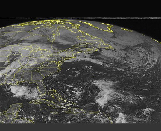
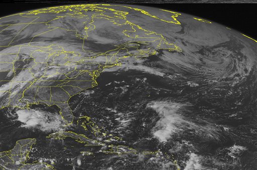
 This NOAA satellite image taken Saturday, October 5, 2013 at 1:45 PM EDT shows clouds extending across the northern portions of the region due to a stationary frontal boundary with some rain and thunderstorms.
NEW ORLEANS - Karen lost more of its punch late Saturday and fell below tropical-storm status while stalling off the Louisiana coast.
Even as a tropical depression with top sustained winds of 35 mph (55 kph), the system threatened to bring strong wind and heavy rain to vulnerable low-lying areas. However, all watches and warnings were discontinued along the Gulf Coast.
The National Weather Service said Saturday evening that the system was stationary but expected to move across or near the southeast Louisiana coast late Saturday or early Sunday, then track eastward and lose strength. It spent Saturday either stalled or moving slowly.
Karen was centered about 185 miles (295 km) southwest of the mouth of the Mississippi River.
Forecasters expected for there to be little change in the system's strength over the next 24 hours and that it would turn into a remnant Monday.
The National Weather Service said storm surges of 1-to-3 feet were possible along the southeast Louisiana and Mississippi coast, with rainfall accumulations of up to 3 inches - 6 inches in isolated areas - along various spots along the central Gulf Coast.
In low-lying Plaquemines Parish, La., officials changed an evacuation order from mandatory to voluntary Saturday afternoon. More than 80 evacuees from the area, at the state's southeastern tip, had taken refuge at a public shelter, which would remain open Saturday.
They gathered in an auditorium where they rested on cots, watched for weather updates on TV and chatted outside on the front steps.
"I don't really know what to expect, but they told us to evacuate, so we got out," said Dana Etienne, 27, of Phoenix, La., who was at the shelter with her three young children.
Ahead of the storm, squalls of rain hit workers sandbagging low sections of the flood-prone town of Lafitte, La., along Bayou Barataria.
"We have a high tide, but we only have another 15-17 hours to worry about, and I don't think the tide will come up much more in that time," Mayor Timothy Kerner said. "It looks like it might come up another foot or two, but I think we're going to be OK."
Coastal authorities closed flood gates along waterways that could be affected by tides driven by the storm. In New Orleans, the U.S. Army Corps of Engineers continued closing barriers designed to keep surge out of the Inner Harbor Navigation Canal - scene of catastrophic flooding in 2005 when flood walls failed during Hurricane Katrina.
Col. Richard Hansen of the corps said more gates along various canals could be closed, and warned boaters not to get caught on the wrong side of those gates "If there is a gate in the system, it may not be open when you decide to come back in," Hansen said. "So it's time to pull your boats out of the water and quit fishing."
At the Port of New Orleans, port officials working with the Coast Guard said they were optimistic that vessel traffic at the mouth of the Mississippi River, halted since Friday morning, would resume Sunday. The port remained busy, officials said in a news release, with some of the nine ships at dock there still working cargo. Two Carnival cruise ships that had to delay weekend arrivals were expected Monday.
Dan Hahn, emergency operations planner for Santa Rosa County in the Florida Panhandle said Karen appeared to be a "nonevent" for the region.
The county had activated its Emergency Operations Center for the weekend, but decided to close it after getting the latest update on the storm's path. Hahn said he and other officials were relieved the storm wasn't more developed. But Hahn still urged residents to pay attention to weather updates and to be prepared for any emergency.
"Complacency is always a concern, but we aren't seeing that," he said, adding that most Panhandle residents take tropical weather seriously because of the large storms that have struck the region in the past.
Mississippi Emergency Management Agency spokesman Brett Carr said the Mississippi National Guard was demobilized Saturday and emergency operations were being scaled back.
As Karen churned the Gulf, some people along the coast couldn't resist the draw of beaches.
Ray and Lynn Walls of Shepherdsville, Ky., had a sunny beach to themselves Saturday on the western tip of Dauphin Island, Ala. Waves pounded the seawall protecting nearby homes, and a locked gate blocked the entrance to a public beach that was closed because of Karen.
In Biloxi, Miss., families played on the beach, joggers trotted along the waterfront and a steady stream of cars passed on the main beach front road.