 The Lincoln Park neighborhood is the area between the railroad overpass, Erlanger, Third Street and Riverside Drive.
WHAT'S NEXTHere is a general timeline of events connected to the plan to create a Third Street to Riverside Neighborhood Plan:Oct. 11: Walkabout / site visitNov. 11: Opportunities & constraints analysisDec. 5: Workshop #1/Visual preferenceDec. 6: Workshop #2/ Design charetteFeb. 10: Draft concept plansJune/July 2015: Final plan presentation
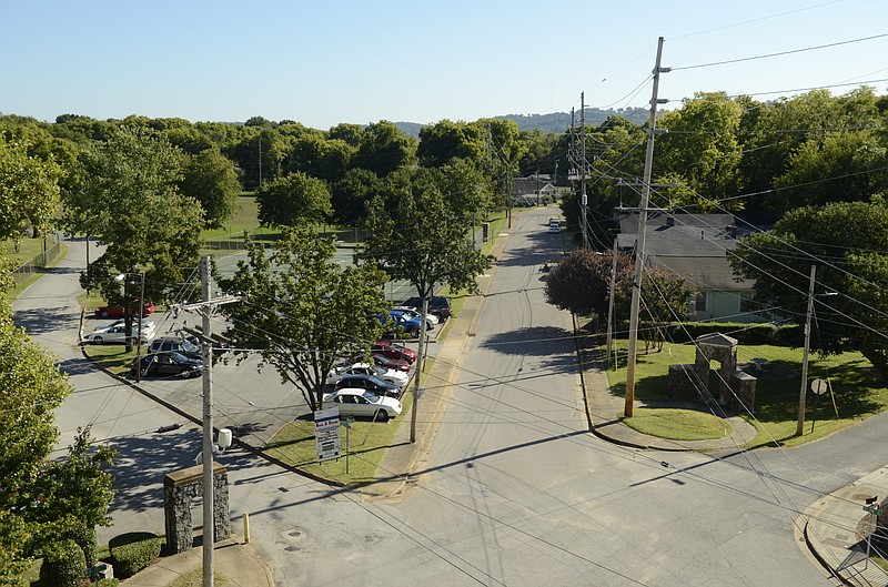
City planners want to transform Third Street and the traffic-racing Riverside Drive into a more connected, pedestrian-friendly zone, and they want to know what residents think about the idea.
"We're hoping to uncover the vision for the area," said Heather Shank, Chattanooga-Hamilton County Regional Planning Agency senior planner.
At present with no plan, Riverside Drive functions as a highway, not a place where people feel safe walking. Yet the road is immediately adjacent to the riverfront, Shank said.
It's also near the Chattanooga Zoo, Chattanooga School for the Arts and Sciences, and Erlanger hospital. Third Street is more urban and pedestrian in some places, but as it gets closer to Veterans Bridge it loses integrity, with very wide lanes and traffic going in both directions, she said.
"The intent is to make the area more pedestrian and more attractive," Shank said. "We want people to mingle more with each other rather than just being in cars."
The planning agency has landed a $200,000 Environmental Protection Agency brownsfield grant to create a Third Street to Riverside Neighborhood Plan.
The planning area includes Riverside Drive and Third Street from Central Avenue to near Engel Stadium. Lincoln Park and Citico Creek are also within the boundaries.
Funding for the plan comes about two years before the city expects to start construction on the nearly $6 million Central Avenue connector. The connector road promises easier access from Central Avenue to Amnicola Highway and could increase access to previously closed-off industrial and warehouse sites near Riverside Drive.
But regardless of the anticipated road, development is moving from downtown to Riverside Drive, Shank said.
"We want to have a plan for it," she said. "Otherwise it [development] could go piecemeal and not in an integrated way."
Only a dozen people attended the first meeting this week. More residents must participate for an inclusive process, Shank said.
The next meeting is scheduled for Oct. 11. The regional planning agency contracted with S&ME Environmental Services to determine priority sites for clean-up and development. S&ME determines if the sites are brownfields based on their previous use.
Shank asked residents attending the first meeting to state their concerns and vision for the community on note cards.
Lisa Mack of Fortwood wants to prevent an increase in traffic through their neighborhoods. Longtime Lincoln Park resident Mary Graham opposed any of her property being consumed by the connector road. And Lincoln Park Neighborhood Association President Vannice Hughley wants to make sure area brownfields did not have contaminants that could make residents sick.
Tiffany Rankins of Lincoln Park said she's not interested in her community being more connected to development or the riverpark.
"I prefer a road not go through Lincoln Park," she said. "They're always telling us about connectivity. We don't care about connectivity. We want our community to stay intact. We want what's left of the park to stay intact."
Shank summarized concerns she heard before the meeting.
UTC wants more greenways for students. Erlanger wants easier road access for ambulances. Lincoln Park wants to maintain the historical significance of its neighborhood, and Fortwood residents want to make sure that neighborhood is not overtaken by UTC.
The goal is a unified plan that considers all concerns, Shank said.
Contact staff writer Yolanda Putman at yputman@timesfreepress.com.