A record-smashing Christmas Day rainfall, punctuated by a series of thunderstorms, pummeled the metro area Friday, flooding low-lying areas and washing out several roads.
Fortunately, traffic was light because of the Christmas holiday, so there were few reports of serious accidents.
Chattanooga broke a Christmas Day precipitation record with 3.85 inches recorded at Lovell Field between midnight and around 10 p.m. as rain continued to fall. That's almost double the previous record, according to meteorologist Derek Eisentrout of the National Weather Service in Morristown, Tenn.
"That's a lot of rain," said Eisentrout, who noted the previous Christmas Day record was 2.01 inches in 1973.
Three people, one a 93-year-old woman, were rescued in Hixson Friday evening after their car was swept off of a road when they drove around a road closure sign. Fire officials said the motorist bypassed the warning on Boy Scout Road near Sandwich Drive in Hixson. The car was pushed off the road by the water and pinned to trees at the side of the road.
Firefighters from the Dallas Bay Volunteer Fire Department pulled the three people to safety.
Interstate 24 westbound was closed for a while around 11 a.m. Friday near Exit 174, Tiftonia-Lookout Mountain, according to the Tennessee Department of Transportation, and then shut down again with an overturned truck around 1:30 p.m. State highway officials were recommending that drivers avoid traveling eastbound on the interstate as of 11 a.m. because of flooding near mile marker 164 in Marion County.
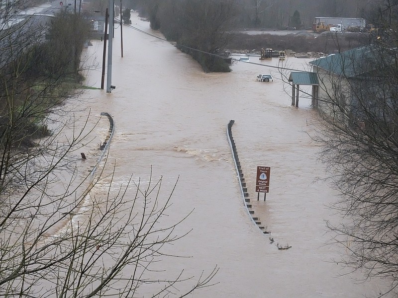
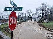
Many residents in the Falling Water community off Dayton Pike had a hard time getting into and out of their neighborhood with several roads reported impassable for a time.
Water was up around the foundations of some homes on Vine Street in Soddy Daisy although police said they had no reports of major flooding.
Roberts Mill Road from the bottom gate to the top gate leading up Signal Mountain was closed after floodwaters washed out a 10-foot-wide gap of pavement in the roadway. Jackson Road north of Roberts Mill Road also was reported impassable, and there was significant water over the roadway near McGill Road and Skip Lane.
By 7 p.m., the National Weather Service was reporting that Lookout Creek at New England, Ga., was 5 feet above flood level; South Chickamauga Creek in Tennessee was a foot above flood level; and the Sequatchie River near Whitwell was slightly above flood stage.
Signal Mountain Boulevard (U.S. 127) was closed for most of the afternoon while Tennessee Department of Transportation crews tried to clean out storm drains to keep water from spilling across the road, according to TDOT spokeswoman Jennifer Flynn. Muddy, impromptu waterfalls spectacularly spilled off the side of the mountain in places.
Chattanooga Police Officer Benny Condra was posted at the foot of the mountain much of the day and used his loudspeaker to warn a steady stream of motorists they could go up 127 only to Balmoral Drive. The road was shut down above that point.
"I must have said this 3,000 times today," Condra lamented as he stopped another driver trying to swerve around him to go up the mountain.
The restrictions pushed traffic up and down Signal over to the W Road, which was backed up in both directions by midafternoon, with about 50 cars waiting to negotiate the three tight hairpin turns at the very top and another 85 backed up all the way up Anderson Pike almost to 127 waiting to come down. Low-hanging clouds wreathed the roadway in mist and the muddy waterfalls plummeted alongside the roadway in the gloom.
By late evening, TDOT workers had cleared the drains, the water level had subsided and Signal Mountain Road was re-opened, Flynn reported.
At the weather service, Eisentrout and his fellow forecasters were almost as busy as Santa overnight and into the day, posting a steady stream of thunderstorm and flooding watches, warnings and advisories.
Some meteorologists worked longer shifts to help deal with the situation, and one weather service employee was called in for several hours just to help post all the warnings and special weather statements, Eisentrout said.
"It's been a long day," he said, fatigue evident in his voice.
Chattanooga also set a temperature record this week, with a new record high low temperature for Wednesday, Dec. 23.
The low temperature that day was 61, compared to 57 for the same day in 1879, Eisentrout said.
The waterlogged area should get a bit of a break today and Sunday, when chances of rain drop to the 30-percent range.
"That being said, we're still in a fairly active weather pattern," Eisentrout noted.
Rain will likely be back Monday, he said, with a 70 percent chance of precipitation.
More flooding?
Perhaps.
The weekend may be a nice break, "but the soil is saturated," Eisentrout said. "A two-day respite is not going to cure that."
Contact reporter Steve Johnson at sjohnson@timesfreepress.com, 423-757-6673, on Twitter @stevejohnsonTFP or follow him on Facebook, facebook.com/noogahealth. Contact Terri Likens at tlikens@timesfreepress.com or 423-757-6597.