
Forecast
› Tuesday: High near 60 degrees, low of 49 degrees, 80 percent chance of rain› Wednesday: High near 58 degrees, low of 43 degrees, 100 percent chance of rain› Thursday: High near 51 degrees, low of 35 degrees, no rain predicted› Friday: High near 45 degrees, low of 30 degrees, no rain predicted› Saturday: High near 46 degrees, low of 30 degrees, no rain predictedSource: The National Weather Service
Also read
* TVA: Dams stop Tennessee River from flooding Chattanooga * Sohn: This crazy weather is not just crazy * Flood watches and warnings in effect for area * State of emergency declared for Gordon County; two deaths reported * Alabama hit with more rain as storms push through state* Stay out of flooded areas, don't drink well water, officials warn* TVA shuts down barge traffic, opens flood gates as water rises * TVA says its dams are saving Chattanooga $130 million in flood damages* Twisters, floods, snow and ice have killed dozens across the South * Don't put away your umbrella, more rain is on the way * 4.14 inches of rainfall doubles prior record; region begins to dry out, assess damage * Thunderstorms, torrential rains pummel metro area* Warmer weather means cheaper winter for most Chattanoogans
Safety tips
› Limit unnecessary driving. If you approach a flooded area, “Turn Around Don’t Drown,” as the National Weather Service advises. Find an alternate route. It is never safe to drive or walk into flooded areas. Do not move barricades to drive on a street that is closed due to flooding. It is dangerous for you, your family, and for emergency crews who would respond to rescue you.› Avoid downed power lines, and call EPB immediately at 423-648-1EPB (1372) to report them.› Report trees or debris blocking a street by calling 311 or (423) 643-6311 and by email at 311@chattanooga.gov.› If an area or street is flooded but not yet closed to the public, please call and report it to 311.› Always treat yellow flashing lights as a yield sign and red flashing lights as a stop sign.› To report non-emergencies, call the Chattanooga Police Department at (423) 698-2525. Always, in the event of an emergency, call 911Source: City of Chattanooga

Don't fret. You'll soon be wearing that scarf and sweater you unwrapped this Christmas, as thermometers are expected to reflect seasonal norms by the new year.
The record-high temperatures felt across the Tennessee Valley will drop by Thursday with cold, dry air moving into the region and staying through the weekend, meteorologists said.
"It's been one of the warmest Decembers we've had in the Chattanooga area and across East Tennessee," said Derek Eisentrout, a meteorologist at the National Weather Service in Morristown, Tenn. "But we are going to get back to seasonal norms quite quickly."
This December may be tallied as the warmest on record but, come January, colder air will have residents replacing their T-shirts with toboggans.
December temperatures in the area typically reach 50 degrees during the day and hover around freezing at night, but this year the Tennessee Valley has seen thermometers repeatedly reach into the 70s.
Eisentrout said several factors played into this December's warmer temperatures.
"This is one of the strongest El Ninos we've ever had," Eisentrout said. "That influences weather across the United States."
El Nino is a year-long change in the pattern of trade winds across the Pacific Ocean, causing ocean temperatures to increase and a variety of drastic weather changes across regions of the United States.
Eisentrout said the positive arctic oscillation at the North and South poles also has contributed to the warmer-than-normal weather, he said.
That means the persistently low pressure at the poles has sucked moist, cold air toward those regions, creating the opposite of an arctic blast, which pushes cold air away from the poles, Eisentrout said.
But by Thursday, cooler air is expected to sweep into the Tennessee Valley as the rain halts.
"It's the snap-back nature of nature," Eisentrout said with a chuckle.
How long will these cooler temperatures last?
"We just don't know," Eisentrout said. "We can only [project] out so far."
As temperatures reach back to seasonal norms, the mosquitoes and flower blossoms trying to peek out will disappear.
Adam Vannest, director of training and technical services for Jody Millard Pest Control, said the recent wave of high temperatures is confusing insects.
"They are starting to come back out of winter mode while it's warm," Vannest said. "Many insects would normally be hibernating."
But if temperatures drop consistently below 50 degrees, as predicted, mosquitoes will stop breeding, and insects such as ladybugs and wasps will no longer be seen, Vannest said.
Shifts in temperature are "nature's healthy way of keeping [insect] populations in check," Vannest said, because if it doesn't get cold this winter, the region will likely see more pests than normal come spring.
Charmaine Yount, assistant general manager at The Barn Nursery, said if the warmer winter temperatures continue they could affect blooming this spring.
An early spring will arrive if temperatures remain unseasonably warm over the next couple of months, Yount said. But if temperatures stay warm and then drop, plants may not be prepared to handle the cold because "many will be entering spring mode" and start to bloom, she said.
She advises people to cover their plants with frost blankets as the temperature drops, especially plants already showing blooms, and to add extra mulch to plants in the ground if temperatures turn cold, as expected.
"The obvious thing is there is nothing we can do about the weather," Yount said. "We just have to let plants do their thing."
***
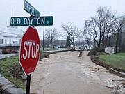
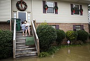
This unusually warm weather fueled additional rain and some severe storms on Monday across the region, which has been pummeled for days with record amounts of rainfall, creating more problems than you forgetting your umbrella.
Chattanooga is expected to remain under a flash flood warning today, but high wind warnings were expected to be lifted early this morning. As of Monday night, no creeks or rivers in the area were experiencing minor or major flooding, according to the National Weather Service's website.
A strong line of thunderstorms battered Alabama on Monday, bringing the threat of tornadoes, stiff winds and heavy rain, according to The Associated Press.
The National Weather Service issued a tornado watch for more than 30 Alabama counties, and more than 20 counties were reporting washed-out roads and bridges Monday, the Associated Press reported.
The rain and flooding over the past week has claimed several lives in Alabama, Georgia and Tennessee.
A man and a 5-year-old were killed in Coffee County, Ala., when their vehicle was swept away by flood waters on Christmas Day as they tried to cross a bridge, according to the AP. Officials in Gordon County, where a state of emergency has been declared, said they recovered the bodies of two people Monday.
In South Pittsburg, Tenn., officials still are looking for the body of Alice "Tiny" Reynolds, who is believed to have fallen into a drainage ditch that leads to the Tennessee River.
For days, crews have scoured the ditch, which is full of storm debris, in search of Reynolds' body, according to Steve Lamb, director of Marion County EMA.
"There is still an area so dense [with debris] we haven't been able to check it yet for her body," he said. "The water levels will need to go down before we can do that."
Eisentrout said more rain is expected to linger in the region today and Wednesday but, come Thursday, you should be safe to leave your rain boots home.
The Associate Press contributed to this story.
Contact staff writer Kendi Anderson at kendi.anderson@timesfreepress.com or 423-757-6592.