Story updated at 9:43 p.m.
This story will be updated throughout the day with news as it breaks.
Counties affected:
TENNESSEE: Rhea Meigs McMinn Northwest Monroe Hamilton Bradley West Polk GEORGIA: Dade Walker Catoosa Whitfield Murray Fannin Gilmer Union Towns Pickens Dawson Lumpkin White
Delays and cancellations
City of Chattanooga buildings, including The Public Library and all its branches - closed University of Tennessee at Chattanooga - closed Lee University - closed Hamilton County schools, including school age child care - closed Dade County Schools - closed All Hamilton County courts - closed Cleveland State all locations - closed Georgia Northwestern Technical College (day and evening classes on all campuses) - closed McCallie Alumni Lunch - now March 26 Walker County Transit - closed Monday, Feb. 16 12th Annual Mardi Gras on Market - postponed Meigs County Schools - closed
National coverage
For national coverage of this historic storm, click here.
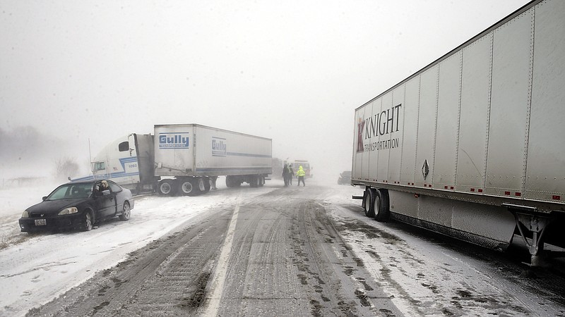
Snow and freezing rain may come to the Chattanooga region early Monday, according to the National Weather Service. The government weather agency has reported that a "significant winter storm" is possible in the Tennessee Valley and Southern Appalachian region.
The National Weather Service updated its forecast Sunday at 3:40 p.m., warning that snow, sleet and freezing rain are all possible across parts of the area. Icy conditions are expected to be a threat in the Chattanooga area, and travel is discouraged.
The service upgraded its winter storm watch to a winter storm warning, cautioning that freezing rain or sleet may be developing, with snow and sleet accumulations of up to an inch possible, and ice accumulations of up to a quarter inch possible.
Hamilton County will partially active its Emergency Operations Center at 6 a.m. as a precautionary measure. The Tennessee Department of Transportation's management center will be operational tonight.
The combined ice and snow accumulation may bring widespread hazardous travel conditions on roadways as well as power outages and tree damage, according to the agency.
By Wednesday, another blast of arctic air will likely move into the area bringing dangerous wind chills for wednesday night and Thursday morning. Temperatures across the region Thursday and Friday mornings will likely be the coldest mornings so far this winter, the National Weather Service warns.
Light snow is possible in the middle to latter parts of the week as well.
PREVIOUS STORY FOLLOWS:
Heavy snowfall accumulation would lead to widespread hazardous travel conditions on roadways, as well as localized power outages and tree damage, according to the NWS. The agency warns consumers that future driving conditions may become hazardous, so continue to monitor the latest forecasts.
"Travel is discouraged Monday and Monday night," the service warns. "If travel is unavoidable, keep an extra flashlight, food and water in your vehicle in case of an emergency."
The National Weather Service is predicting a 40 percent chance of snow starting around 4 a.m. on Presidents' Day, and a 100 percent chance of snow and freezing rain throughout the day on Monday.
The temperature may drop as low as 22 degrees tonight in Chattanooga, and Monday's high is expected to be just 32 degrees. Snow could accumulate two to four inches, and ice may accumulate up to a tenth of an inch. Snow may linger on the ground for several days, because of the frigid temperatures, the National Weather Service reported.
Accumulated ice is extremely dangerous, and experts typically warn that the safest course of action is to stay indoors and off the roads until the ice has completely cleared.
Though many schools are already off on Monday for Washington's Birthday, also known as Presidents Day, Tuesday's weather forecast presently offers no respite with the National Weather Service calling for a 40 percent chance of snow before 10 a.m., and a high of just 35 degrees.
Hamilton County Emergency Services has warned that exposed pipes may freeze, and that homeowners should bring in pets and check on the elderly or those with insufficient heat.
In Hamilton County, the Tennessee Department of Transportation on Friday pretreated roads on Lookout Mountain and Signal Mountain with brine, and on Saturday pretreated the rest of the Interstate and state highways, according to spokeswoman Jennifer Flynn.
Crews are now resting in preparation for what could be a couple long days of work. This evening, Hamilton County crews will load their trucks with salt in order to deal with the expected conditions.
Report closings to news@timesfreepress.com.
Cold weather car tips from AAA
1. Check anti-freeze to see that it protects the engine down to -30 F.2. If the battery is weak or more than three years old, consider replacing it.3. Put winter-blended windshield washer fluid in the reservoir so that the windshield can be cleaned at critical times without icing up.4. Fill the gas tank to help avoid fuel line freeze-up.5. If the tire pressures are low, fill them up today the extreme cold weather will make them dangerously underinflated tomorrow.6. If not possible to park the car in a garage, consider covering the windshield with a blanket or some other large cloth, anchoring it in the doors and under the windshield wipers. This can eliminate manually scraping ice off the windshield tomorrow, or waiting long times for the engine and defroster to clear the ice.7. Consider what to take inside from the car tonight: portable electronic items may be damaged by extreme cold and containers of water or other fluids may freeze and then burst when warmed up tomorrow.8. It will be tempting to start the engine tomorrow morning and let it idle to warm up the car. Some automotive experts approve of that, others don't, but in any case remember that other car systems suspension, braking, hydraulic, electronic, tires will not have warmed up when the car first starts moving. Travel at moderate speeds the first couple of miles to let the entire car warm up.9. If a motorist becomes stranded, there are no absolutely guaranteed ways to stay safe, but AAA recommends that it is best to stay with the vehicle. If the engine can be started, run it only long enough to keep warm. Make sure the exhaust pipe is snow-free. Always travel with a cell phone and car charger.
Cold-proofing home tips from State Farm
* Insulate pipes in the crawl spaces and attic * Heat tape or heat cables can be used to wrap pipes * Seal leaks that allow cold air inside near where pipes are located with caulk or insulation * Disconnect garden hoses * A trickle of both hot and cold water can keep pipes from freezing * Keep thermostat up at night, no lower than 55 degrees. * Open cabinet doors to allow heat to get to un-insulated pipes under sinks and appliances near exterior walls * If pipes freeze, leave faucets turned on and call a plumber * If pipes burst, turn off water at main shutoff valve in the house, leave the water faucets turned on.