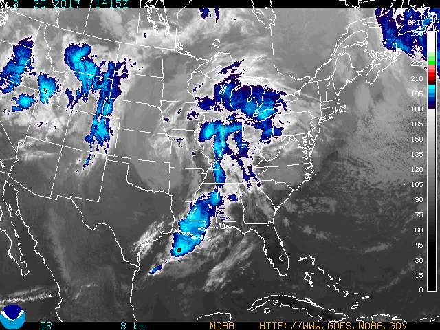
 A satellite image from the National Weather Service shows a storm system moving toward the Tennessee Valley.
Update at 9:40 p.m.: The National Weather Service continues to predict strong overnight storms are possible in East Tennessee, including Hamilton County and the surrounding areas.
The Weather Channel radar shows the storm's intensity waning with the heaviest thunderstorms missing the Chattanooga area.
The National Weather Service warns of widespread showers and thunderstorms throughout the area with a risk of severe thunderstorms.
The main threat will be strong winds and hail, according to the National Weather Service.
---
They say 'April showers bring May flowers', but the storms that are expected to hit southeast Tennessee, including Hamilton County and surrounding areas, could bring isolated tornadoes, according to the National Weather Service.
A hazardous weather outlook has been issued by the federal weather agency for east Tennessee, including Hamilton County, Bradley County, Marion County, Polk County, Bledsoe County, Rhea County, Meigs County and McMinn County.
There is a risk of severe thunderstorms late this afternoon and tonight, especially in southeast Tennessee.
A strong storm system producing showers and potentially severe thunderstorms is expected to move across the Tennessee Valley today and tonight. Damaging winds and hail are the main threat, but isolated tornadoes and heavy rains are possible, according to the National Weather Service.
Strong winds are also expected to develop late Thursday and continue into early Friday morning. Gusts up to 55 miles per hour are possible. A wind advisory is in effect for the far east Tennessee mountains and foothills today and tonight.