
After 10 straight days of precipitation that left the Tennessee River in a raging fury and the Chattanooga region soggy from more than 10 inches of rain, most residents likely are ready for a break.
"Just 'for the record' we have received 10.6 inches of rain, which makes it the [third] wettest February on record so far," WRCB-TV Channel 3 chief meteorologist Paul Barys wrote in his Monday weather blog. "We could easily slip into second place with another [half inch] of rain before the end of the month."
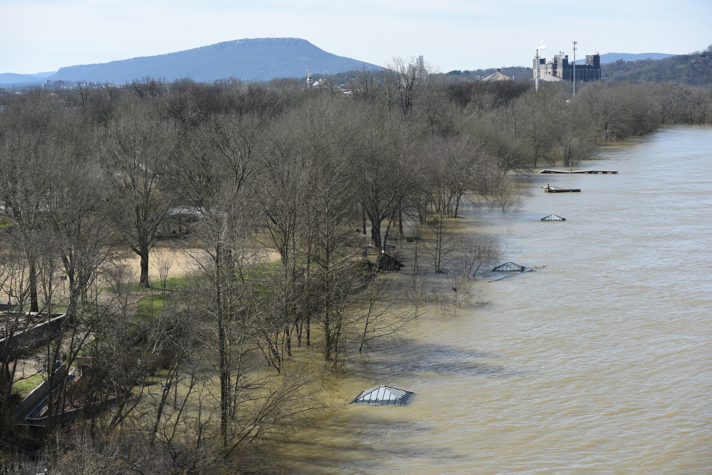 Only the rooftops of the fishing piers at the Tennessee Riverpark are visible below the Chickamauga Dam at 11 a.m. Monday.
Despite the sunny skies, a flood warning remains in effect until noon Tuesday as runoff from the past week's rains makes its way downhill and downstream, according to the National Weather Service office in Morristown, Tennessee.
Over the last week or so, the damage tally has included homes, a Trenton, Georgia convenience store parking lot, a Signal Mountain Road Subway restaurant and roads throughout the region. The storm system spawned deadly tornadoes in some parts of the South over the weekend and prompted a state-of-emergency declaration in Tennessee on Saturday. Shelters were opened in the Sequatchie Valley and elsewhere for folks forced from their homes by flooding, buildings and homes were damaged in Rhea County, and a Geraldine, Alabama, man was swept away in a flooded creek in Buck's Pocket State Park in Jackson County, officials said.
Flooding was still being reported mid-morning on Monday on West Chickamauga Creek, and South Chickamauga Creek was causing problems across Catoosa County, Georgia, and South Hamilton County in Tennessee, weather service officials said in the warning.
Five-day forecast
TuesdayPartly cloudyHigh: 65Low: 35WednesdayClouds and sun, 20 percent chance showers lateHigh: 63Low: 48ThursdayMostly cloudy, 40 percent chance of rainHigh: 62Low: 50FridayMostly cloudy, 50 percent chance of rain>High: 60Low: 47SaturdayMostly cloudy, 50 percent chance of rainHigh: 55Low: 45Source: WRCB-TV Channel 3
At 9:15 a.m. Monday, West Chickamauga Creek was at 12 feet and falling. Flood stage there is 11 feet. South Chickamauga Creek was at 20.2 feet early Monday and falling. Flood stage on South Chickamauga Creek is 18 feet, weather service records show.
Spillways at Tennessee Valley Authority dams on the Tennessee River have been flowing furiously for days now to keep up with continuing rainfall. The Tennessee River crested late in the morning on Monday and the flow at Chickamauga Dam was in excess of 172,000 cubic feet per second throughout the day.
The Tennessee River region in the last 10 days has seen 4 to 5 inches of precipitation in East Tennessee and in Southwest Virginia and up to 12-13 inches in North Alabama, TVA River Forecast Center manager James Everett said Monday during a conference call with media.
The federal utility is spilling water through most of its dams to reduce water levels to make room for storage of more rainfall in the coming days, Everett said.
TVA's large, deep tributary dams in upper East Tennessee already have been restraining as much water as possible to keep from allowing too much to flow downstream, but now are discharging to make room for more rain forecast for later this week, Everett said.
Downstream dams such as Watts Bar, Chickamauga, Nickajack, Guntersville and Pickwick are already at summer pool or higher, Everett said, so spillways are open to keep from exceeding maximum levels.
The operation from end to end of TVA's reservoir system is a balancing act, he said.
Everett said TVA has to be mindful that the Ohio and Mississippi rivers are high as well and the downstream flow from the Tennessee River must be controlled. Some of the worst areas over the last few days have been farther downstream on the Tennessee River near Savannah, officials said.
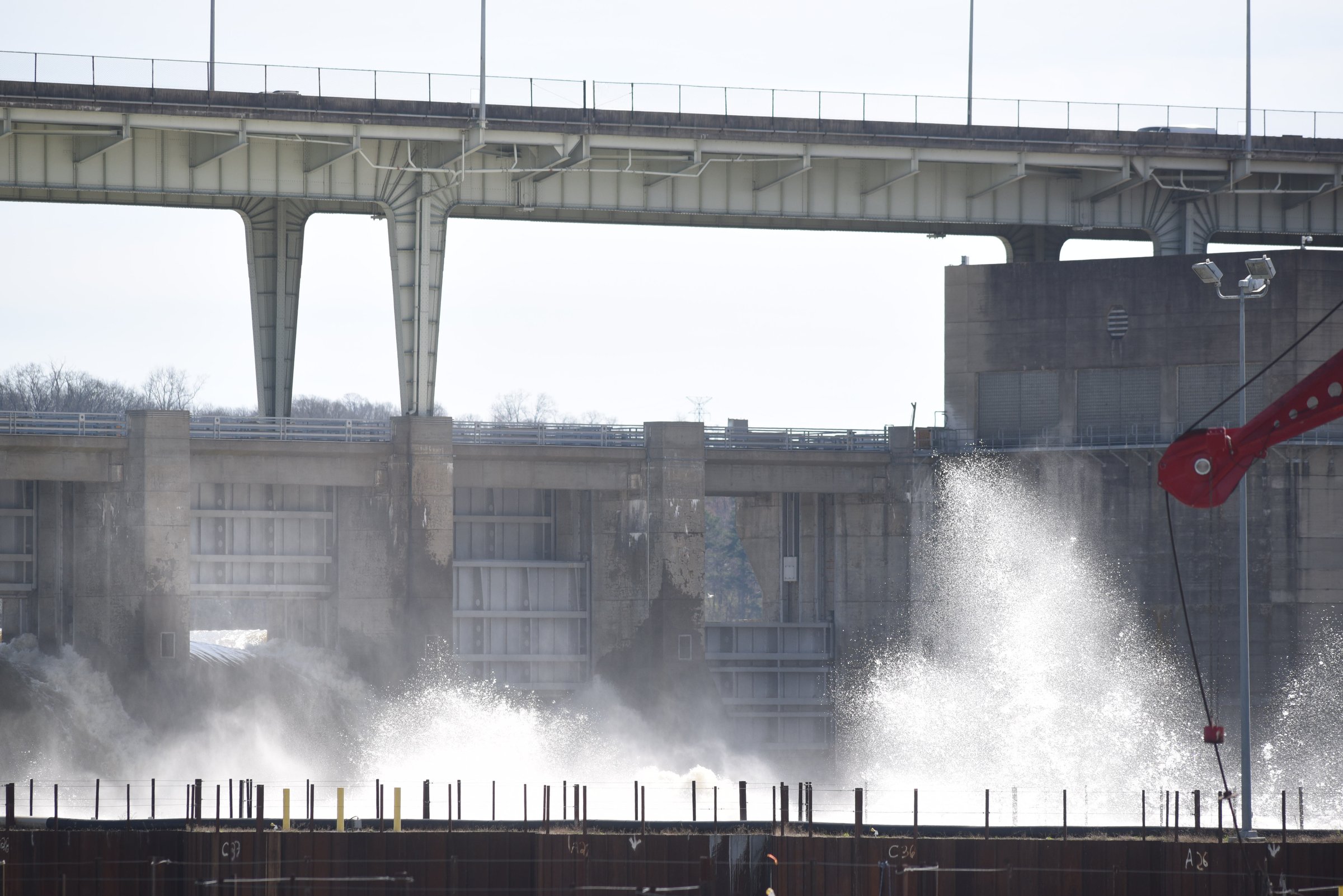 Water sprays high above the coffer dam surrounding the new lock construction below the Chickamauga Dam on Monday before noon.
Meanwhile, Tennessee Gov. Bill Lee won't be visiting the damage caused throughout the state by recent storm activity over the weekend, but he plans on remaining in close communication with emergency officials to monitor the situation, according to The Associated Press.
Lee's spokeswoman Laine Arnold told the AP the governor planned to meet with cabinet members Monday to review ongoing issues connected to the heavy rainfall.
Arnold says the flooding wasn't as extensive or widespread as initially feared and added that the governor's office feels the more prudent decision would be to let local resources focus on repairs without distractions.
However, the Tennessee Emergency Management Agency and the governor's office will continue to keep an eye out as rivers and other bodies of water still have the potential to flood over the next few days.
Contact staff writer Ben Benton at bbenton@timesfreepress.com or 423-757-6569. Follow him on Twitter @BenBenton or at www.facebook.com/benbenton1.