Why we love it: Too many reasons to count
Closest town to visitor center: Monteagle, Tenn.
Drive time from Chattanooga: 50 minutes
Maybe it's just the rose-colored glasses of spring, but we think South Cumberland State Park may be one of the best. The park boasts several claims to fame: Some of the region's top-rated trails and backcountry camping and one of the largest cave openings in the state share the land with scenic overlooks, awe-inspiring geological formations, numerous waterfalls, swimming holes and noted climbing opportunities.
The diverse opportunities are so grand, in fact, that they couldn't be held to one place. They're sprawled over 25,539 acres in nine separate areas across four East Tennessee counties (Sequatchie, Grundy, Marion and Franklin), coming together to make one hell of a whole.
Savage Gulf Natural Area
The Savage Gulf and Stone Door areas which comprise the vast Savage Gulf Natural Area feature much more than the giant rock slit that looks like a door to another dimension, though that is impressive enough. More, even, than the waterfalls and sweeping vistas of the green-carpeted South Cumberland Plateau as it ripples through the gorge below. You'll also find history within the 55 miles of multi-level trails.
The Stagecoach Trail, which ties in with the Collins Gulf Trail for a 12.6-mile loop, is one of the harder treks. As you traverse the combined 1,719 feet in elevation change, imagine using the Stagecoach Trail back around the mid-1800s. The former toll road was constructed in the 1840s to connect Chattanooga and McMinnville.
Get there:
(east) Savage Gulf Ranger Station: 3177 SR 399, Palmer, Tenn.
931-779-3532
(west) Stone Door Ranger Station: 1183 Stone Door Road, Beersheba Springs, Tenn. | 931-692-3887
Grundy Forest Natural Area
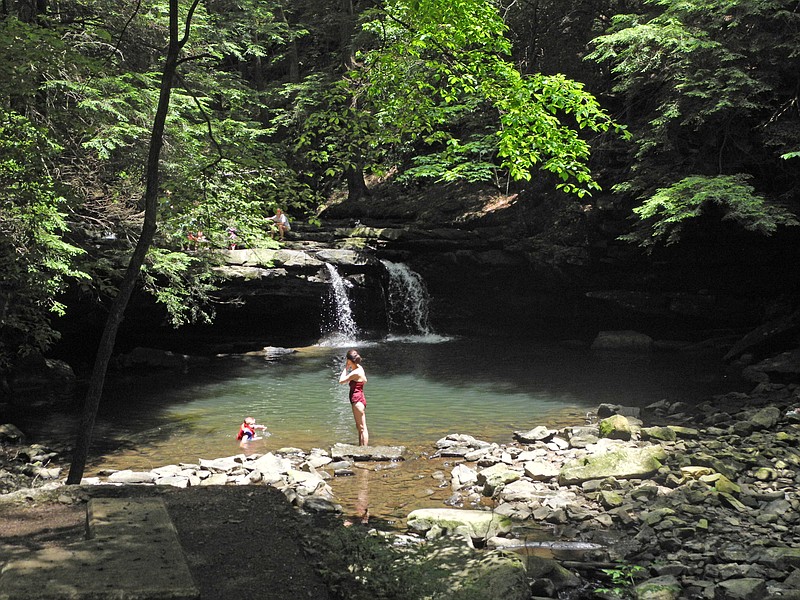
Perhaps the most noted section of the park is Fiery Gizzard Trail in the Grundy Forest Natural Area. The 12.5-mile out-and-back trail has been rated one of the top 25 in the country, though it is considered difficult. The magnificent waterfalls, clear, cold pools and frothily moving streams are quite a draw. Add to that Jenga-like rock formations and overlooks that will simply take your breath away, and you can see why this is a list-topper.
The trail is named for the creek it runs alongside. But how the creek got its name is another issue. There are several legends. One says an Indian chief, to gain attention during peace talks with Europeans, threw a turkey gizzard into the fire. That Davy Crockett burned his tongue on a turkey gizzard and spit it into the creek is another story. If nothing else, we encourage you to go make your own stories along this trail.
Get there:
(south) Foster Falls: 498 Foster Falls Road, Tracy Highway 41, Sequatchie, Tenn.
(north) Grundy Forest Trailhead: 131 Fiery Gizzard Road, Tracy City, Tenn.
Carter State Natural Area
As its name implies, Lost Cove is like a prehistoric holdover forgotten by time. The more-than-5,000-acre sink hole in the Carter State Natural Area is home to several rare species of plants and animals. It's a great place to watch growth crawl its way back into the landscape this time of year, little bursts of color glittering across the underbrush as spring wildflowers begin their show. The dense forest is considered one of the most biodiverse in the nation.
Two other-worldly natural formations share this part of the landscape. Sewanee Natural Bridge is an often-photographed arch that rises out of the forest like the remnants of a castle wall. The Sewanee Natural Bridge Trail combines with the Buggytop Trail for a moderate 4.2-mile out-and-back journey which will also take you to one of the largest cave openings in the state. Buggytop Cave actually has two entrances besides the impressive main. Peter Cave entrance opens into the Indian Room, an archaeological treasure trove. But be careful: Lost Creek runs through portions of the cave.
Get there:
From exit 134 on Interstate 24, turn left onto US41A toward Sewanee. Drive 5 1/2 miles. Turn left onto TN-56 Sherwood Road. Go about 10 miles to Carter Cave State Natural Area parking on the left.