
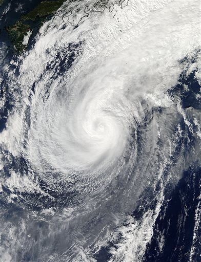
 This Nov. 5, 2014, photo provided by NASA shows a picture captured by NASA's Aqua satellite of Typhoon Nuri.
ANCHORAGE, Alaska - The edge of a rapidly intensifying storm began pummeling parts of Alaska's Aleutian Islands on Friday, signaling its arrival by lashing the western tip of the island chain with hurricane-force winds.
Sustained winds of 70 mph and gusts up to 96 mph were recorded Friday morning on Shemya Island, where 120 people had locked themselves indoors to wait out the storm.
The brunt of the storm - the remains of Typhoon Nuri - is expected to pass into the Bering Sea and weaken as early as Saturday, but it will still push unseasonably frigid air into much of the U.S. next week, the National Weather Service said.
Shemya Island is where the U.S. military operates Eareckson Air Station, which serves mainly as an early warning radar installation. Acting manager Don Llewellyn said no one is going outside, but people can see light poles waving.
Forecasters said waves could be as high as 50 feet, prompting ships and fishing vessels to get out of the storm's path or seek protected harbors.
The storm was expected to surpass the intensity of 2012's Superstorm Sandy and has the potential to be one of the most intensive to ever hit the North Pacific, meteorologists said. But while Sandy was blamed for at least 182 deaths and $65 billion in damage on the East Coast, Nuri's target is a sparsely populated region with just a few small communities where people are accustomed to severe weather.
Friday's high temperature was in the mid-40s in Shemya, which is in a sub-polar region that doesn't get the same bitter cold as Alaska's interior. But the island 1,500 miles southwest of Anchorage gets plenty of extreme weather, including 100-mile winds. The community averages six weather-related lockdowns a year, Llewellyn said.
"This is nothing new to us," he told The Associated Press in a telephone interview. "This one's a little bit more intense, but it's something that we're prepared to deal with."
The system is expected to freeze much of the lower 48 states next week, forecaster Bruce Sullivan said. Snow also is coming to areas including the northern Rockies and northern Plains.
In Great Falls, Montana, the high temperature is predicted to be 17 degrees Tuesday, compared with the normal high of 43, Sullivan said. The forecast for Sioux Falls, South Dakota, is a high of 25, which is about 20 degrees below normal. High temperatures in Minneapolis will only reach the upper 20s.
Amid prospects that the storm could dip into the upper Midwest, National Weather Service meteorologist Gino Izzi in Chicago offered a warning to that region's populace: Winter is about to hit, sooner there than usual.
Izzi said highs there are expected to settle into the 30s from Tuesday through Friday, while nightly lows could drop into the 20s, perhaps even the teens.
"It doesn't look real promising for a warmup after that, either," he said of the longer-range forecast that meteorologists hadn't sorted out by Friday.
In Sioux Falls, weather service meteorological technician Tim Masters said temperatures will be colder than average but won't break any records.
"We've been above normal most of the fall, so this is our first shot going the other way being below normal," he said. "Basically, this is a wakeup call that this is November and it can get pretty cold this time of year. Hopefully we don't stay that cold very long."
In the Aleutians, the storm's path includes a busy maritime route for cargo ships traveling between the U.S. and Asia, as well as the red king crab fishery made famous by the Discovery Channel reality show "Deadliest Catch." Mariners were finding protected harbors or moving away from the path, according to Brett Farrell with the nonprofit Marine Exchange of Alaska. No one in their right mind would stick around that area, he said.
Officials are also closely watching the western coast of Alaska's mainland, according to Jeremy Zidek, a spokesman for the state Department of Homeland Security and Emergency Management. Fall storms routinely batter many coastal communities, and erosion has long been a problem.