School closings and delays
CLOSED Bledsoe County Schools Cumberland County Schools Grundy County Schools Motlow State Community College DELAYED Hardy Memorial School
Weekend forecast
Friday: Sunny, with high near 42 and low around 26 Saturday: Sunny, with high near 57 and low around 34 Sunday: Mostly sunny, with high near 57 and low around 38
Chattanooga escaped winter's grasp after bracing for another round of misery.
Most of Southeast Tennessee was able to avoid predicted snow and ice Thursday, as the morning's rain cleared out before the freezing temperatures arrived.
Weathermen believe the region may have dodged winter's last blast.
"Looks like this was the last winter precipitation of the season," said meteorologist Sam Roberts, with the National Weather Service in Morristown, Tenn. "Each day we get further into March, the lower our chances are [of getting] snow."
He acknowledged that the Tennessee Valley has been hit by significant snow on dates deeper into March - citing the blizzard of 1993, which buried Chattanooga under almost 2 feet deep. But this year, the long-term models are not showing any future wintry weather, Roberts said.
"Hopefully this [was] the last scare," he said. In fact, the forecast calls for sun and temperatures in the 50s by the weekend.
However, the northern parts of the state were not as fortunate. Three related deaths - the result of motor accidents in three separate counties - were reported on Thursday, according to Tennessee Emergency Management Agency officials, bringing the number of weather-related deaths to 33 since the tumultuous wintry weather arrived in the state on Feb. 16.
Eighteen inches of snow was recorded along the Kentucky and Tennessee border, TEMA spokesman Dean Flener said. But in the southeastern portion of the state, fears of snow or ice snapping power lines and trees didn't come true.
"There is just rain right now on the Cumberland Plateau," he said Thursday afternoon. "The concern is potential flooding."
The inaction was a welcome relief to Volunteer Energy Cooperative, the utility that serves many counties on the plateau. Spokesman Robert McCarty called last week's storm the most devastating ice storm in the cooperative's history.
"We are just now getting clear of the last storm," he said Thursday morning. "We are really hoping we don't get hammered by this next one."
He said last week's storm was more damaging than an F2 tornado.
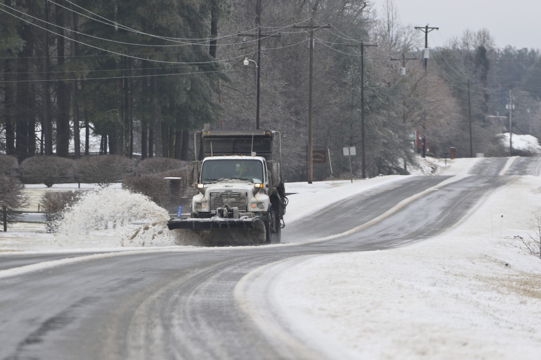 A snow plow removes a layer of ice and snow from Highway 41A between Monteagle and Sewanee after frozen precipitation coated the higher elevations of East Tennessee on Thursday, March 5, 2015.
"Because a tornado has a much more narrow path," McCarty said. "This ice storm went everywhere throughout Cumberland County."
The storm damage in the 17-county VEC service area is estimated to be $9.5 million, as more than 700 utility poles were broken and about 400,000 VEC customers lost power.
"We have never seen this kind of damage before," McCarty said. "If we lose power again it's enough to make a preacher cuss."
Just the warning of more ice and snow brought school cancellations and business delays Thursday.
At the state Capitol in Nashville, enough state House and Senate members turned up to open their chambers and conduct brief business. Most major business, however, was put off until Monday as lawmakers headed home, worried about dealing with ice- and snow-covered roads across the state.
In the Senate, Speaker Pro Tem Bo Watson, R-Hixson, presided, with Speaker Ron Ramsey, R-Blountville, reportedly out of state.
"Be safe, everyone," Watson told senators as they adjourned.
Locally, there wasn't much preparation for Thursday's potential storm, unlike what Chattanoogans experienced last week.
"We were not very concerned," said Amy Maxwell, spokeswoman for Hamilton County Emergency Services. "Looks like everything is clear."
Staff writer Andy Sher contributed to this report.
Contact staff writer Kendi Anderson at kendi.anderson@timesfreepress.com or at 423-757-6592.
Cold weather car tips from AAA
1. Check anti-freeze to see that it protects the engine down to -30 F.2. If the battery is weak or more than three years old, consider replacing it.3. Put winter-blended windshield washer fluid in the reservoir so that the windshield can be cleaned at critical times without icing up.4. Fill the gas tank to help avoid fuel line freeze-up.5. If the tire pressures are low, fill them up today the extreme cold weather will make them dangerously underinflated tomorrow.6. If not possible to park the car in a garage, consider covering the windshield with a blanket or some other large cloth, anchoring it in the doors and under the windshield wipers. This can eliminate manually scraping ice off the windshield tomorrow, or waiting long times for the engine and defroster to clear the ice.7. Consider what to take inside from the car tonight: portable electronic items may be damaged by extreme cold and containers of water or other fluids may freeze and then burst when warmed up tomorrow.8. It will be tempting to start the engine tomorrow morning and let it idle to warm up the car. Some automotive experts approve of that, others don't, but in any case remember that other car systems suspension, braking, hydraulic, electronic, tires will not have warmed up when the car first starts moving. Travel at moderate speeds the first couple of miles to let the entire car warm up.9. If a motorist becomes stranded, there are no absolutely guaranteed ways to stay safe, but AAA recommends that it is best to stay with the vehicle. If the engine can be started, run it only long enough to keep warm. Make sure the exhaust pipe is snow-free. Always travel with a cell phone and car charger.
Cold-proofing home tips from State Farm
* Insulate pipes in the crawl spaces and attic * Heat tape or heat cables can be used to wrap pipes * Seal leaks that allow cold air inside near where pipes are located with caulk or insulation * Disconnect garden hoses * A trickle of both hot and cold water can keep pipes from freezing * Keep thermostat up at night, no lower than 55 degrees. * Open cabinet doors to allow heat to get to un-insulated pipes under sinks and appliances near exterior walls * If pipes freeze, leave faucets turned on and call a plumber * If pipes burst, turn off water at main shutoff valve in the house, leave the water faucets turned on.