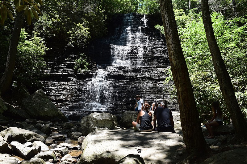

ETOWAH, Tenn. - The Southern Appalachian Mountains that lie within the Tennessee Overhill Heritage Association's three-county footprint are home to dozens of waterfalls, but for years they have been more side notes than destinations.
The association, which most people simply call Tennessee Overhill, awaits the next major printing of its new, full-color waterfalls travel brochure, first released last season. The brochure - "Waterfalls of the Tennessee Overhill" - consists of a map, Polk County sites on one side and Monroe County sites on the other, with detailed directions, site descriptions and important notes on accessibility, parking and traveler advice.
"Tennessee Overhill" honors the Cherokee settlements that once sat alongside the rivers that wind through McMinn, Monroe and Polk counties.
Association executive director Gerald Hodge Jr. said supplies of the waterfalls brochure are limited now but he expects to have a new batch in hand "within a month." People wiped out the brochures when the first printing was released, he said.
The multi-page brochure, which folds out like a map, has lots of details about waterfall sites and other historically or geologically significant sites along the way, Hodge said. All of the waterfalls featured lie in Monroe and Polk counties.
"The waterfall brochure has allowed us to package what we have to offer and put it into the hands of the public to get outside and enjoy," he said.
Although there are at least 60 known waterfalls in the area, the brochure features those that are most accessible and impressive. Hodge said some waterfalls not listed are located on or are only accessible by traveling through private property. Some are very dangerous to reach or are almost unreachable, he said.
"Bald River Falls is the only one with handicap access," Hodge said. Hiking ratings for trails leading to waterfall sites usually refer to the steepness of ascent and descent.
Hodge said there also are areas where bluff edges present dangers, so visitors should be especially watchful if any children are with them.
Waterfalls offer something different in foliage and water levels with changing seasons.
"Some of them freeze in the wintertime. Bald River Falls is amazing sometimes," Hodge said.
"It's kind of a quest. There's even a rainbow at the end of some," he said.
The Tennessee Overhill Heritage Association is housed in the Etowah Depot on Tennessee Avenue and has brochures and plenty of other information available. Officials can answer specific questions and help find sites.
Contact staff writer Ben Benton at bbenton@timesfreepress.com or twitter.com/BenBenton or www.facebook.com/ben.benton1 or 423-757-6569.
Cherokee Forest Waterfalls
Here are 16 waterfalls in Polk and Monroe countie and a brief description and ratings for hiking difficulty .Polk County› Benton Falls, atop Chilhowee Mountain, is a 65-foot high step-like cascade. $3 day-use fee. Moderate to easy hike› Rock Creek Gorge Scenic Area, off U.S. Highway 64 has a number of waterfalls. Moderate hike› Coker Creek Falls, near the town of Coker Creek, is a series of waterfalls ranging from five- to 45-feet high. Easy to moderate hike› Lowry Falls is a series of cascades, including one with a 10-foot drop, off of Tennessee Highway 30. Moderate to difficult hike› Goforth Creek Falls, off of U.S. Highway 64, is a series of picturesque cascades and pools. Easy, short hike› Turtletown Falls, near Farner, consist of a 40-foot water fall and another 30-foot high one. Moderate to difficult hike› Gee Creek Falls, north of Benton, consist of numerous waterfalls of varying sizes surrounded by rhododendron and older-growth trees. Easy hikeMonroe County› Bald River Falls is a spectacular 90-foot waterfall, handicap accessible, is a favorite among photographers. Visible from Forestry Service Road 210 bridge› Kahuna Falls is a 10-foot high waterfall in the Bald River area. Hike varies in difficulty› Bald River Cascades are a series of small waterfalls in the Bald River area. Hike varies in difficulty› Baby Falls is a 15-foot high waterfall near Fire Service Road 210. Falls are just more than 300 feet from the parking area.› Conasauga Creek Falls is 35 feet high a few miles from Tellico Plains. One-mile round-trip hike› Fall Branch Falls, at 70 feet high, is one of the larger falls featured in the brochure, off the Cherohala Skyway. Hike is difficult and not recommended for those not in good shape› Holder Cove is home to waterfalls near the campground. Hike is rated as easy› Middle Double Camp is a series of three cascades can be seen from the Forest Service Road.› Torino Falls is a 12-foot-high waterfall and part of a series of cascades in the Bald River area. Hike rated easySource: Tennessee Overhill Heritage Association
GET INFO
For a free copy of the waterfall brochure, email info@tennesseeoverhill.com or call 423-263-7232 or 877-510-5765. Visitors can also stop by the Tennessee Overhill Heritage Association office in the Etowah Depot at 727 Tennessee Ave. Open weekdays 8 a.m to 4:30 p.m. Go to TennesseeOverhill.com for more information.
BE SAFE
WATERFALLSWaterfalls sites can present significant fall and drowning dangers and, in most areas, cell phone service is unavailable.• Be sure to calculate at least a half hour to hike each trail mile and another half hour for each 1,000 feet of elevation.• Tell someone where you are going and when you plan to return• Wear appropriate shoes• Check the weather forecast and stay aware of changing conditions• Take seasonal precautions and be prepared for wet weather• Don’t wade streams to reach a waterfall or wade the waters above or below falls, rocks are slippery• Never jump from waterfalls• Don’t disregard “no trespassing” signs or venture onto private propertyDANGEROUS WILDLIFE• Do not approach bears or allow them to approach you• Do not feed bears• Carry bear spray when in more remote areas• Do not attempt bear “selfies”• Do not approach feral hogs or dogs• Do not pick up or touch reptiles; some are poisonous• Predominant problem insects to watch out for are ticks and brown recluse spiders.Source: Tennessee Overhill Heritage Association