NEW ORLEANS - The Latest on Deep South severe weather (all times local):
10:15 p.m.
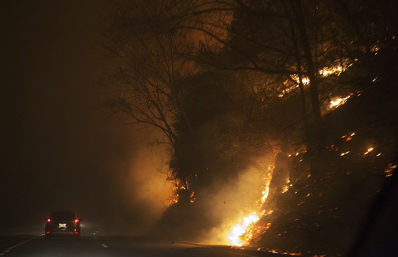
Emergency officials in Tennessee say a wildfire has set 30 structures ablaze in Gatlinburg, Tenn., including a 16-story hotel, and is at the edge of the Dollywood theme park.
Tennessee Emergency Management Agency spokesman Dean Flener says in a news release Monday night that mandatory evacuations were underway for areas in and around Gatlinburg, including the south part of Pigeon Forge, where Dolly Parton's theme park is.
Flener says strong afternoon winds fanned the wildfire on land in the great Smoky Mountains National Park to move quickly onto private property.
TEMA says no deaths have been reported.
___
7:45 p.m.
Officials say several areas are being evacuated because of fires in and around Great Smoky Mountains National Park in Tennessee.
Gatlinburg police had been going door to door in one neighborhood asking for voluntary evacuations. But the Knoxville News Sentinel reported that as wind picked up and fallen trees sparked fires from downed lines, Gatlinburg fire officials declared a mandatory evacuation of a larger area.
The newspaper said some park employees were also evacuating and some locations closed.
A news release from the Gatlinburg Chamber of Commerce said the National Park Service reported more fire growth expected in the park with spot fires possibly forming outside the main area.
___
6:45 p.m.
Roaring winds have been followed by an inch or more of rain across much of Mississippi Monday but not enough to break a months-long drought.
National Weather Service meteorologist Eric Carpenter says areas of northeast Louisiana and Mississippi's Delta region got more than an inch, and parts of central and northeast Mississippi were also likely to reach that total. As of last week, more than 70 percent of the state was classified as being in extreme drought.
Trees were reported downed in nearly 20 counties across the state, with gusts of more than 50 mph in multiple locations.
Power outages peaked at more than 23,000 statewide. Mississippi Emergency Management Agency spokesman Greg Flynn says powerlines downed by winds sparked grass fires in four central Mississippi counties.
Though at least one tornado warning was posted, for Noxubee County, Carpenter says no tornadoes were confirmed by early Monday evening.
___
5:15 p.m.
A storm system moving across the South announced itself in Mississippi with hours of wind before heavy rains arrived.
Damage was light, but trees were reported down in at least eight counties, including one that fell on the town hall in the 100-resident hamlet of Eden in the state's Delta region. Yazoo County Emergency Management Director Jack Willingham says the metal building is damaged beyond repair, but no one was injured. Photos taken by Willingham show a tree branch plunged through the roof.
Statewide, power outages rose to nearly 23,000 by 5 p.m., with the heaviest numbers around Jackson and in Tallahatchie County.
Forecasters say a threat of strong wind and possibly an isolated tornado persists through the evening.
More than 2 inches of rain fell in some areas.
___
3:30 p.m.
Fire officials say a storm system moving across the South appears to be heading toward many of the largest ongoing wildfires and will help suppress them.
However, authorities say the rain moving across parts of Mississippi, Alabama and Tennessee on Monday likely won't end the fire threat and dangers posed by the blazes. Several of the largest fires are in Georgia and North Carolina.
Dave Martin of the U.S. Forest Service says high winds on the leading edge of the front could topple dead trees and put firefighters in danger. But Martin said the rains will certainly help the overall situation.
Forest Service spokesman Adam Rondeau says there are 24 large wildfires now burning throughout the southern U.S., covering about 133,000 acres.
___
1:30 p.m.
More than 14,000 customers are without power in Mississippi as heavy winds accompany rain into the state.
Outages are concentrated in central and southeast Mississippi, according to power providers.
Entergy Corp., Mississippi's single largest utility, reported 6,800 users without power Monday afternoon, with the largest numbers in Rankin and Hinds counties.
Southern Pine Electric Power Association reported 4,500 customers without power, mostly in Copiah, Scott and Smith counties.
Sustained winds above 20 mph were being reported at Jackson International Airport and Meridian's Key Field. A gust of 54 mph was reported Monday morning at Clarksdale.
___
12:35 p.m.
The Storm Prediction Center in Norman, Oklahoma, has issued a tornado watch for western and northern Louisiana. The watch is in effect until 5 p.m. Monday.
The weather service says thunderstorms will slowly increase in coverage and intensity through the afternoon and spreading into northwest Louisiana.
Forecasters say the storm environment will become more favorable for supercells with the potential to produce a few tornadoes.
A tornado watch means conditions are favorable for tornadoes to form.
___
9:05 a.m.
Most of the Deep South is under the threat of severe weather through Wednesday.
The Storm Prediction Center in Norman, Oklahoma, says a cold front approaching Louisiana, Mississippi, Alabama and Georgia will bring thunderstorms to the region.
The weather service says damaging winds will be the primary threat, with tornadoes also possible. Some storms could produce possibly severe hail.
Northern Louisiana and northern Mississippi will see gusty winds of up to 40 mph and brief heavy downpours on Monday. Rainfall amounts will average a quarter to half of an inch, with isolated higher amounts of up to an inch possible.
The weather service says the rain water should be soaked up quickly because of severe drought conditions across the Deep South.