Consider adding wind to your worry list if you haven't already.
"Severe thunderstorm winds can be just as strong as EF-1 tornadoes [86-110 mph]," said Anthony Cavallucci, a meteorologist with the National Weather Service in Morristown, Tenn. "They are also much more common than tornadoes in East Tennessee."
Four wind events in the last seven months have brought home the point:
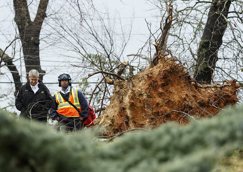
A 90 mph wind on Nov. 28, 2016, turned a small fire in the Chimney Tops Trail area of the Great Smoky Mountains into a wildfire that burned 17,000-plus acres. That blaze destroyed or damaged some 2,400 structures, killed 14 people and injured 134 in Sevier County, Tenn.
A wind later classified as a tornado caused millions of dollars in damage in the Athens area on Nov. 29. A May 4 wind reaching speeds of 100 mph in some places added to the suffering in Sevier County, causing $1.5 million in damage.
And a wind and thunderstorm on May 27 knocked down trees and cut off electric power to 45,000 in Knoxville.
"Strong thunderstorm winds usually occur when a stalled frontal boundary, strong cold front or a complex of thunderstorms moves through the area when the atmospheric conditions are ripe," Cavallucci said. "This means that there is plenty of moisture, instability, lift and wind shear. These are the ingredients for severe thunderstorms to develop and can occur any time of the year."
Jeremy Buckles, another weather service meteorologist in Morristown, said those conditions are particularly acute in the Chattanooga area, which experiences warm, unstable weather from the south as well as chilly air from the northwest that mixes overhead and causes havoc.
"You get a lot of low-level moisture and instability from the Gulf of Mexico, and a lot of times you'll get those frontal boundaries and cold fronts coming from the northwest," he said.
***
Wind has always been a fact of East Tennessee life.
The National Centers for Environmental Information provides a database with information back to the 1950s. A search back 20 years to 1997 shows no indication that the number of high-wind incidents is growing. That number ranges from highs of 65 high-wind events in 2008 and 2009 to lows of two in 1997 and 1998.
A series of storms throughout 2016 brought severe winds with it.
"There were at least a dozen or so in the Chattanooga area with severe thunderstorms with at least some damaging winds," Buckles said. "Trees down for instance, power outages, road signs and things like that."
He also said it's inaccurate to believe that living in a mountainous region like Hamilton County or some of its surrounding counties offers natural protection from tornadic activity.
"That line of thinking is something you do hear a lot of around here, but it really isn't completely accurate," Buckles said. "It will come to the area, really unhindered a lot of the times."
The weather service has two wind advisories: a High Wind Warning for expected sustained winds of 40 mph or more that last for at least an hour and a Wind Advisory for expected sustained winds of 26-39 mph for at least one hour.
Winds are usually associated with thunderstorms because both involve the collision of weather systems.
"When it comes to thunderstorm warnings, the average lead time is just over 19 minutes," Cavallucci said. "That means that there are approximately 19 minutes after we issue the severe thunderstorm warning that the winds/hail are reported."
***
Detecting wind is an expensive, and sometimes unsuccessful, challenge.
The Narional Weather Service admitted misjudging a recent wind incident in Clinton, N.C. The service predicted winds topping 50 mph, but the area received winds over 90 mph that downed trees and power lines and tore roofs off houses.
A media report on that event quotes the weather service explaining that the closest radar to the area was shooting a beam at 3,000 feet and that everything below 3,000 feet it could not see. A weather service meteorologist explained that the farther away a radar station is, the less that can be seen.
"Wind detection costs money," Cavallucci said. "We have the Doppler radar which helps us see wind speeds within the thunderstorms and some environmental winds above the surface, but we don't have a lot of ground stations similar to what's at McGhee Tyson Airport."
That Knoxville airport has an Automated Surface Observing Station that includes an array of instruments for observing temperature, precipitation, wind, sky cover, visibility and pressure. The real beauty of the station is that it runs 24-7 and can produce continuous data.
"We also utilize and ingest home weather stations," Cavallucci said. "Some of that data requires a lot of quality control because of possible siting issues, like putting the wind gauge on top of a roof or under a tree."
In addition, he said there is a Citizen Weather Observer Program in which a little more than 200 residents throughout the state send weather information via the internet to the National Weather Service and other agencies.
***
"We could always use more data," Cavallucci said. "For example, some states like Oklahoma and Texas have mesonets - weather stations in every county that monitor wind, temperature, rainfall, etc. Some are funded by universities and/or state government."
Mesonets are automated weather and environmental monitoring stations. They are valuable for measuring bigger patterns such as squall lines or dry lines.
The National Park Service also has wind monitoring sites but is not in the forecasting business.
"We do not have a meteorologist on staff who provides weather forecasting," Great Smoky Mountains National Park spokeswoman Dana Soehn said. "We work closely with the NWS office in Morristown, whose staff provide us with regular briefings during storm events for the mountains."
Watching the wind is a vital part of the National Weather Service work day.
"We monitor these conditions every day, because the results could potentially be life-threatening," Cavallucci said. "Our mission is to protect life and property, and we do this by monitoring these weather conditions and issuing warnings when the threat to life and property are present."
Staff writer Emmett Gienapp contributed to this story.