
If you don't really think about it, those giant boulders looming above State Route 30 west of Pikeville, Tennessee, look like they've been there forever.
But water, vibration and gravity have been conspiring for decades to weaken the slope where Highway 30 in the Sequatchie Valley ascends Wheeler Mountain to the Cumberland Plateau. Rock slides happen every few years either above the roadway or below it where the path carves its way through the rocky bluff.
The Tennessee Department of Transportation is studying Highway 30's slide-prone areas near the top of the mountain for a potential fix.
A rock slide in 2009 and a collapse in 2016 forced traffic reroutes and repair work on the two-lane, winding state road, one of the primary westbound routes to Fall Creek Falls State Park on the Bledsoe-Van Buren county line. An alternative route is State Route 111.
In the early morning hours of April 8, 2009, a rock slide from above the roadway closed both lanes of Highway 30 to traffic for about 10 hours while crews removed rocks and trees. The road was reopened the same day.
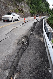
Deterioration of the earth beneath Highway 30 near the bluff line forced TDOT in June 2016 to launch a $1.6 million emergency project to repair the stretch of road at the 7.5-mile mark going up the mountain. The road settled and cracked open as the earth beneath it began collapsing in February 2016, state officials said at the time.
Engineers in 2016 did a visual assessment and followed up with exploratory drilling, concluding that the failure was in front of an existing row of soldier piles installed more than 20 years ago and adjacent to a soil nailing project completed in 2015. Highway 30 was closed and traffic was detoured for more than a month.
TDOT spokeswoman Jennifer Flynn said Tuesday that state crews recently painted some orange markings and numbers on Highway 30, foretelling more stabilization work to come.
"[T]he paint is for a future rockfall mitigation project that our Geotechnical Engineering Section is developing at log miles 7.4 and 7.8," Flynn said.
TDOT officials "painted stationing on the rock so their drone could take pictures of the areas that our geotechnical engineers are interested in," Flynn said. "Our project developers are working on the design of the rockfall mitigation project."
Flynn said no date has been set bidding the mitigation work.
Drones are used more and more to help engineers to assess problems. They can photograph areas of potential rockfall and document construction projects, TDOT Region 2 civil engineering manager 1 Don VanHook said via email. They also can survey unsafe and hard-to-reach locations.
The Region 2 office, which covers 24 counties in Southeast Tennessee and on the Cumberland Plateau, has two licensed drone operators, he said.
"We are excited to expand on the use of this technology and hope to start using drone photogrammetry at some point in the future," VanHook said. "Photogrammetry" refers to the technical process of using photographic imagery to make measurements in surveying.
"Earlier this year when [State Route] 68 in Rhea County washed away, our survey crew used the drone to assess some of the area that was unstable," Flynn said. "We have used the drone to photograph the slope stabilization projects on U.S. [Highway] 127," the portion known best locally as Signal Mountain Boulevard.
Contact staff writer Ben Benton at bbenton@timesfreepress.com or on Twitter twitter.com/BenBenton or on Facebook at www.facebook.com/ben.benton1 or 423-757-6569.