
COKER CREEK, Tenn. - Damage done in 2014 by the U.S. Forest Service to a section of the Trail of Tears in Monroe County, Tennessee, still has not been repaired, but federal officials say a fix is in the works.
In 2016, Forest Service officials admitted agency crews built as many as 35 earthen berms in 2014 to control erosion and discourage off-road vehicles along a little under a mile of the Trail of Tears that amounted to a "terrible error," Southern Region U.S. Forest Service regional forester Tony Tooke said three years ago. On the far side of many of the berms - ranging from 2-4-feet high - equally deep "tank traps" were built to stop vehicles from being able to cross the berms.
Bonnie Marie Morris, a Coker Creek, Tennessee, resident who lives near the Trail of Tears/Unicoi Turnpike area, is fuming that the Forest Service hasn't fixed the damage in more than five years.
Morris visited the site in May, noting "it appears that absolutely nothing has been done to rectify the damage to the Trail of Tears section near the Unicoi Turnpike."
"I'd like to be able to walk the Trail like it was before the damage," Morris said. "It is the right of any American Indian, or anyone else who has the desire to show their respect for the men, women, and children who had to walk that trail on their way to Oklahoma.
"It's the responsibility of the Forest Service to fix it in a timely manner and not wait another five years to do it."
Don't give up yet, federal officials said this week.
On Thursday, Forest Service spokeswoman Stephanie Johnson said the federal agency has been "conducting a very deliberate and inclusive process involving tribal government representatives and other consulting parties" including the Alabama Coushatta Tribe of Texas, Coushatta Tribe of Louisiana, Eastern Band of the Cherokee Indians, Kialegee Tribal Town, Muscogee (Creek) Nation, Poarch Bank of Creek Indians, Thlopthlocco Tribal Town, United Keetoowah Band of Cherokee Indians, Coker Creek Heritage Group, National Park Service/National Trails Intermountain Region, Tennessee Valley Authority, Tennessee State Historic Preservation Officer and the Advisory Council on Historic Preservation.
"Because of the cultural, spiritual and historical significance of this site, meetings with tribal representatives and other consulting parties have been ongoing since 2015," Johnson said in an email. "In 2017, the U.S. Forest Service signed a formal apology for the damage to the Trail of Tears during a special ceremony with tribal government representatives. Also, extensive archaeological inventory and assessment work have been conducted, leading to this section of the Trail of Tears now being eligible for Historic Places designation by the Advisory Council of Historic Preservation."
Meanwhile, nature is taking its course.
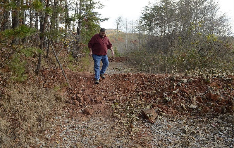
At the height of summer in Tennessee's eastern mountains Wednesday, kudzu was growing waist-high and higher at the gated entrance to the Trail of Tears segment, and the first 3- to 4-foot high berm is invisible under the thick, tangled vines. The tank trap on the other side of the first berm looks flat, but is covered with kudzu with water underneath of unknown depth, probably two to three feet deep. The trail itself is nearly impassable for the first 50 yards or so.
What the trail farther north lacks in kudzu, it makes up for in dense weeds and undergrowth but it's still walkable, if just barely. On the other hand, there was no obvious recent damage from off-roaders - one of the things the berms were intended to prevent - or even many signs of anyone or anything passing through but animals.
The berms continuing along the trail are covered with vegetation, as well, and the traps are all filled with water with some erosion showing where the traps overflow when it rains.
Attempts to reach Eastern Band of Cherokee Indians Principal Chief Richard Sneed, Cherokee Nation Principal Chief Bill John Baker and United Keetoowah Band of Cherokee Indians in Oklahoma Chief Joe Bunch, all of the three federally recognized bands of the Cherokee - were not successful .
The Trail of Tears Association is behind the Forest Service's plans.
The Forest Service has made a "great effort to mitigate the damage done [including] Several meetings and lots of planning with much input from UKB, Cherokee Nation and EBCI, as well as interested parties such as Trail of Tears Association," executive director of the National Trail of Tears Association Troy Wayne Poteete said in an email. Poteete is a former chief justice of the Cherokee Nation.
"To say they have ignored the situation would be a gross mischaracterization," Poteete said.
Poteete said the association "does support the efforts and will be supportive of whatever the tribes find agreeable."
The money for the work is there; the Forest Service just needs everyone onboard.
Johnson said the agency is working with the interested parties to finalize a memorandum of agreement "that will address the physical remediation of the damaged portions of the trail designed to facilitate pedestrian access on the damaged section while taking special precautions to avoid further adverse impacts to the National Historic Trail."
The agency also has established a coordinator "to implement the MOA stipulations, including coordinating with tribal youth to assist with the remediation efforts. The MOA is being reviewed by all tribal government representatives and consulting parties," she said. "Once signed, remediation work at the site will begin within one year. This will include extensive archaeological techniques to ensure proper protection and curation of any discovered artifacts.
"Additionally, the Forest Service will host cultural sensitivity training for its employees, assist with trail immersion summer camps for tribal youth, and work with local heritage groups to improve education/interpretation of the tribal importance of the Trail of Tears," she said.
The agency will also do a "cultural landscape inventory of the Unicoi Turnpike and Trail of Tears National Historic Trail, and amend the current Cherokee National Forest plan to designate the cultural landscape and set long-term forest management direction," Johnson said.
"Funding for the work outlined in the MOA is available, and the work remains a funding priority," she said.
Contact Ben Benton at bbenton@timesfreepress.com or 423-757-6569. Follow him on Twitter @BenBenton or at www.facebook.com/benbenton1.
DAMAGE TIMELINE
The timeline below are parts of a larger document that was released by the group Public Employees for Environmental Responsibility in September 2016. PEER obtained the timeline and distributed it with its statement calling for an independent investigation of the damage done to the Trail of Tears segment in Coker Creek, Tenn.2008: Parcel containing the Trail of Tears/Unicoi Turnpike segment is identified for acquisition2011: The Conservation Fund agrees to purchase 461 acres of the 571 acre tract and hold for the U.S. Forest Service.2012: The Conservation Fund purchases the tract from River Valley AgCredit.Jan. 15, 2013: Special Warranty Deed for the tract conveyed from River Valley AgCredit is recorded in the Monroe County Registrar’s OfficeJan. 25, 2013: The District Ranger contacted the forest hydrologist and the forest engineer to use soil and water funds in combination with an equipment rental contract to stabilize erosion on the existing logging roads and skid trails which had no erosion control measures and gullies on the road were more than 18 inches deep in some places. The ranger informed the hydrologist that National Environmental Policy Act permitting was not necessary because the Forest Service did not own the propertyApril 2, 2013: Several folks, including the forest hydrologist and forest engineer lay out some potential locations for water bars and tank traps to protect from erosion and All‐Terrain Vehicle and Off Highway Vehicle use.July 9, 2013: Purchase and task order for $28,500 is signed at the supervisor’s office for work on Peels Branch and Little Citico Creek.July 22, 2013: Forest hydrologist’s email to the district ranger demonstrates knowledge that the location of the Trail of Tears on the site corresponds to vital road segmentsJuly 25, 2013: District ranger, forest hydrologist, forest archaeologist, assistant forest archaeologist and an engineering tech, who was representing the forest engineer, met at the site. The district ranger and forest hydrologist assumed that the group was meeting to determine if there were any cultural resource concerns that warranted modifications to their proposed scope of work for erosion control and stabilization. The group walked the segment of road from Joe Brown Highway to Peels Branch including a side trip up an adjoining spur road. Then, the group forged down Peels Branch to its confluence with Coker Creek. The forest hydrologist recalls stating that the pink flagging was located where the ground disturbance was proposed and the erosion control features were discussed. The district ranger states that water bars were not clearly defined in their discussion. However, neither the forest archaeologist nor the assistant forest archaeologist recall being told during the field visit of any specific project or that any work was planned along the Trail of Tears/Unicoi Turnpike route itself. The expectations for the site visit were not clearly defined. The district ranger and forest hydrologist left the meeting thinking that there were no cultural resource concerns, and that they had concurrence to move forward with the erosion stabilization work. Both the forest archaeologist and the assistant forest archaeologist left the meeting unaware of any project work or project proposal being conceived and agreed upon within the Trail of Tears.Aug. 8, 2013: Forest Service signs purchase option and contract with The Conservation Fund to acquire two parcels containing nearly one mile of the Unicoi Turnpike, Trail of TearsJan. 30, 2014: Forest hydrologist says she emails forest engineer and district wildlife technician indicating that the district ranger had given approval to start the work. The approval from the district ranger was verbal. Note: There is no evidence The Conservation Fund received written notice from the regional forester for the Forest Service to occupy and administer work on the property.March 3, 2014: A gate is installed on the road access to keep people from driving along the Trail of Tears and Unicoi Turnpike. TVA and Forest Service place locks on gate to access road.March 3-7, 2014: Work to construct 32 large water bars along the Trail of Tears/Unicoi Turnpike is conducted. The work on the trail is only part of the project, erosion control work is also done on logging and spur roads in the parcel.May 28, 2014: Gate damage is noticed.June 6, 2014: Forestry Service contractor repairs damaged gate. Also builds three tank traps on Trail of Tears/Unicoi TurnpikeSept. 25, 2014: Parcel is transferred to the Forest Service.July 14, 2015: A group participating in the charrette regarding the Trail of Tears, Unicoi Turnpike, and Fort Armistead visits the site and sees the damage done to the Trail of Tears and Unicoi Turnpike. This group includes National Park Service National Historic Trail staff, the forest archaeologist, the hydrologist, and others. Most of the group is astounded and perplexed by the work that was done.July 15, 2015: An Eastern Band of Cherokee Indians Tribal Historic Preservation Office representative and two assistant U.S. attorneys, who were participating in the charrette, are informally notified by the forest archeologist about the damage to the Trail of Tears.July 16, 2015: The forest supervisor decides to perform a management inquiry of the event. The new Tellico district ranger is asked to lead the review.Aug. 19, 2015: In order to protect important resources and ensure policy and procedures are being followed, forest supervisor institutes an updated internal policyOct. 28, 2015: The Forest receives letter from the Eastern Band of Cherokee Indians dated 10/28/2015 regarding the reported damage. No formal, individual response to this letter was written (see Dec. 23, 2015, entry). However the Regional Tribal Relations program manager did call EBCI staff that same day to confirm receipt and discuss.Oct. 29, 2015: U.S. Attorney, two Assistant U.S. attorneys, USFS Law Enforcement representatives, Technical Services Group Staff Officer, forest archaeologist and assistant forest archaeologist visit Fort Armistead and damaged segment of Trail of Tears.Nov. 23, 2015: The Forest Service receives letter from the ACHP dated 11/23/2015 regarding the reported damage. The letter was copied to the Washington Office. The Forest Service’s federal preservation officer, the director of recreation, heritage and volunteer resources, the director of the Office of Tribal Relations, and two associate deputy chiefs become involved and contact the regional forester.Nov. 23, 2015: The regional forester visits Fort Armistead near the damaged trail with the forest supervisor, forest archaeologist, Technical Services Group staff officer and USFS Law Enforcement representatives.Nov. 30, 2015: The forest supervisor, regional office staff and Washington office staff begin to discuss how to address the ACHP’s letter and being process of moving forward with consultation on mitigation. Forest Service begins contacting tribes and SHPO to setup a meeting in Oklahoma regarding the incident.Dec. 16, 2015: Forest Service formally replies to ACHP’s Nov. 23, 2015, letter requesting additional time prior to providing list of proposed mitigation/remediation actions in order to consult with tribes and other consulting parties.Dec. 23, 2015: Forest Service sends letter to the consulting tribes and Tennessee SHPO with the Dec. 16 letter to the ACHP attached along with a summary of the internal management inquiry. The letter invites the tribes and Tennessee SHPO to attend a meeting to discuss the adverse impact in early February.January 2016: Forest Service prepare for the meeting in Catoosa, Okla.Feb. 3-4, 2016: Meeting with affected tribes, Trail of Tears Association, National Park Service and the Tennessee SHPO is held in Tulsa, Okla. The consulting tribes inform the Forest Service that the Unicoi Turnpike, Trail of Tears and Fort Armistead are sacred sites.Feb. 23-25, 2016: Regional forester shares news of the adverse impact and his concerns regarding proper consideration and management of cultural resources to all the forest supervisors in the southern region during the regional leadership team meeting.Feb. 29-March 4, 2016: Regional forester spends week on the Cherokee National Forest in Tennessee and spends time on each ranger district discussing the adverse impact.March 2, 2016: First conference call with the consulting tribes after the Tulsa meeting to discuss use of a Facilitated Learning Assessment (FLA) with tribal member participation to determine the thought processes and oversights that led to the adverse impact occurring.March 8, 2016: Second conference call with all the consulting tribes regarding use of the FLA process. At this time, the FLA idea was abandoned at the request of the tribes. Also on this date, the Eastern Band of Cherokee Indians send a letter to the regional forester formally designating the Unicoi Turnpike, Trail of Tears and Fort Armistead as sacred sites.March 14-17, 2016: Two specialists from the NPS National Historic Trails Program Intermountain Region visit to assess damage to the Trail of Tears and make recommendations for remediation and mitigation. They are accompanied at different times during the week by tribal representatives including EBCI; United Keetoowah Band of Cherokee Indians; Alabama‐Quassarte and Thlopthlocco, as well as, a partner from Western Carolina University.March 15-16, 2016: Section 106 Training on the Cherokee National Forest for all district rangers, forest staff officers, NEPA coordinators, and program managers taught by representatives from the ACHP.March 17, 2016: ACHP representative visits the damaged portion of the Trail of Tears/Unicoi Turnpike and Fort Armistead. Later that day the forest leadership team and others from the Cherokee National Forest along with the regional archaeologist visit the damaged portion of the Trail of Tears and Fort Armistead. At Fort Armistead, they have a listening session with the tribal members from the EBCI, UKB, Thlopthlocco, and Alabama‐Quassarte.March 18, 2016: Regional forester holds a conference call with all the forest archaeologists in the region discussing the adverse impact to the Trail of Tears/Unicoi Turnpike.March 21, 2016: The United Keetoowah Band of Cherokee Indians in Oklahoma send letter declaring the Trail of Tears, Unicoi Turnpike and Fort Armistead sacred sites.March 18-22, 2016: The forest hydrologist pulls together field notes and emails regarding the 2013‐2014 project into a report for the forest supervisor and tribes.April 8, 2016: Letter sent from the regional forester to the EBCI acknowledging the sacred sites designation.April 11‐14, 2016: Tribes discuss with Regional Forester Tony Tooke the next steps and the spiritual damage to the tribes caused by the project physically damaging the Trail of Tears.May 10, 2016: Letter sent from the regional forester to the UKB acknowledging the sacred sites designation.Source: U.S. Forest Service/Public Employees for Environmental Responsibility