After Mother Nature dumped a record high rainfall on the Tennessee Valley in February following the wettest year on record last year, the Tennessee River has risen 12 feet above normal in Chattanooga and is within 3 feet of flood stage.
The high water has shut down river navigation and flooded thousands of acres downstream in Alabama, Mississippi and West Tennessee. But the Tennessee Valley Authority estimates its network of 49 dams and river control operations helped avoid at least $1.6 billion of flood damage, most of it in Chattanooga, where much of the city would have been underwater without TVA.
"This has been one for the record books and we're doing everything we can, working around the clock to limit as much flooding as we can from all this rain," said James Everett, manager of the TVA River Forecast Center in Knoxville.
More rain is in the forecast for Sunday, with predictions of another inch or two of precipitation in parts of the Valley. Everett said the soggy conditions and high water will likely linger and cause TVA to continue to spill water through its dams for weeks to come.
"Our work is far from over, and we're probably looking at several weeks before it gets back to normal," Everett said.
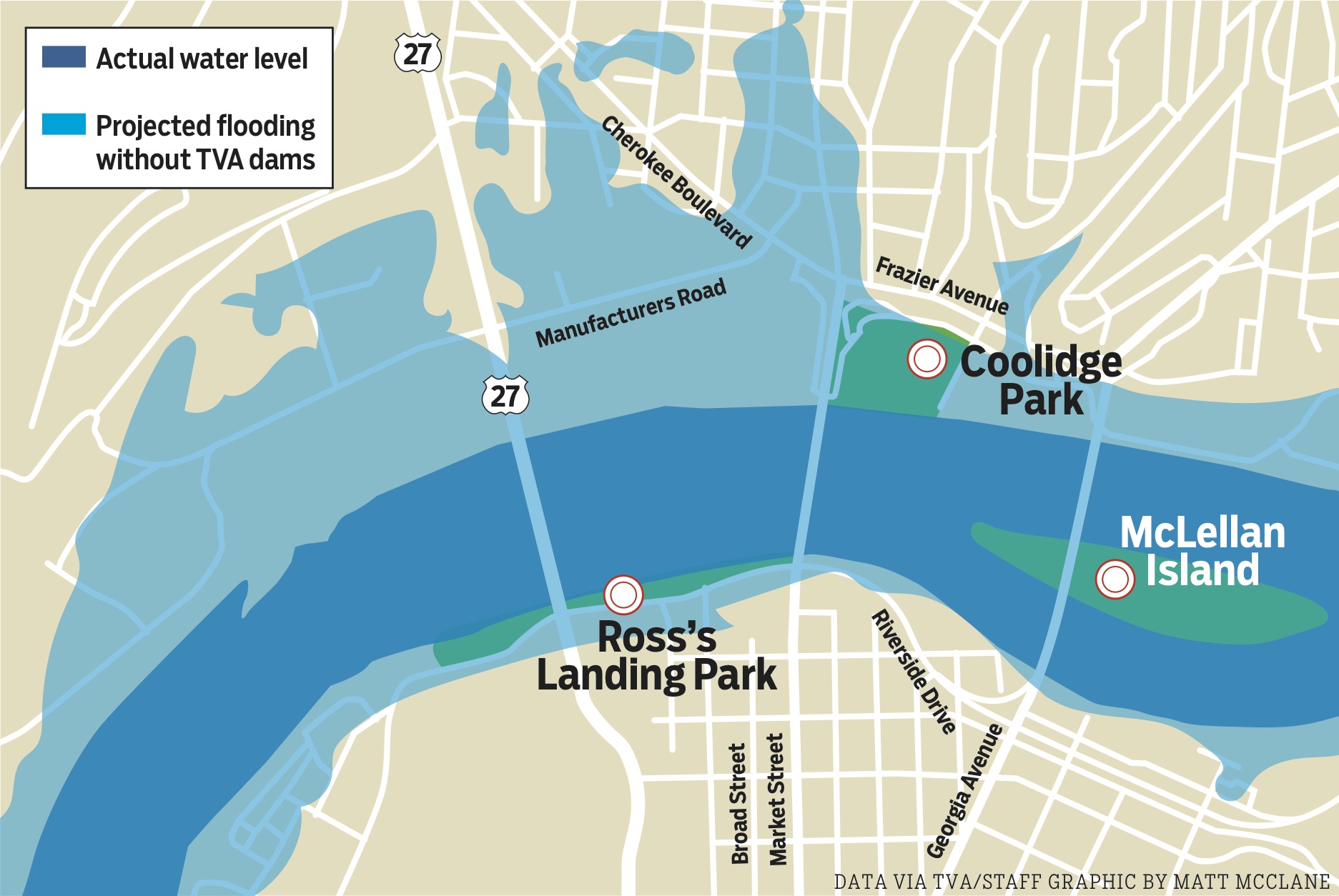 This illustration shows the areas in downtown Chattanooga that would have been inundated by water if not for TVA's network of dams.
TVA was able to store nearly 3.6 trillion gallons of water - or more than what New York City consumes in a decade - by holding back flows during heavy rains in its upstream reservoirs, some of which rose as much as 26 feet in depth during last month's sustained rains.
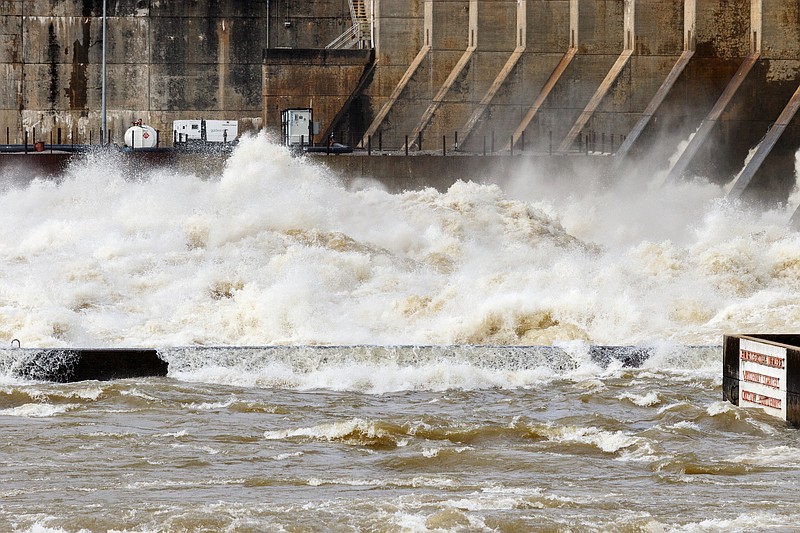
As all that water is released, the flow has made the Tennessee River's navigation too dangerous for most boats and barges and has raised water levels to flood low-lying areas in the Tennessee River basin.
Nearly 1.4 million gallons of water a second was spilling through the Chickamauga Dam in Chattanooga on Saturday - nearly double the point where the U.S. Coast Guard advises barge traffic not to operate on the river in Chattanooga. Most of the Tennessee River and Tennessee-Tombigbee waterway is now shut off for river navigation because of the high water, causing some cement, chemical and other users of river shipments to turn to rail or trucks for shipments and delivery.
"I've never seen anything like this in my lifetime," said Cline Jones, executive director at the Tennessee River Valley Association, which represents the barges that transport millions of tons of shipments a year using the Tennessee River and its tributaries. "It's stalled up and down the Tennessee River and nothing is moving right now and may not move for a while."
The heavy rains are even more widespread across the Valley this winter than the last time the Tennessee River reached its current height in Chattanooga back in July 2013, following heavy summertime rains that year.
In Tennessee, 64 counties have suffered severe weather and flooding effects, including 16 that have declared states of emergency, according to the Tennessee Emergency Management Agency. The state Emergency Operations Center is staying open through the weekend to respond to ongoing problems, TEMA spokesman Dean Flener said.
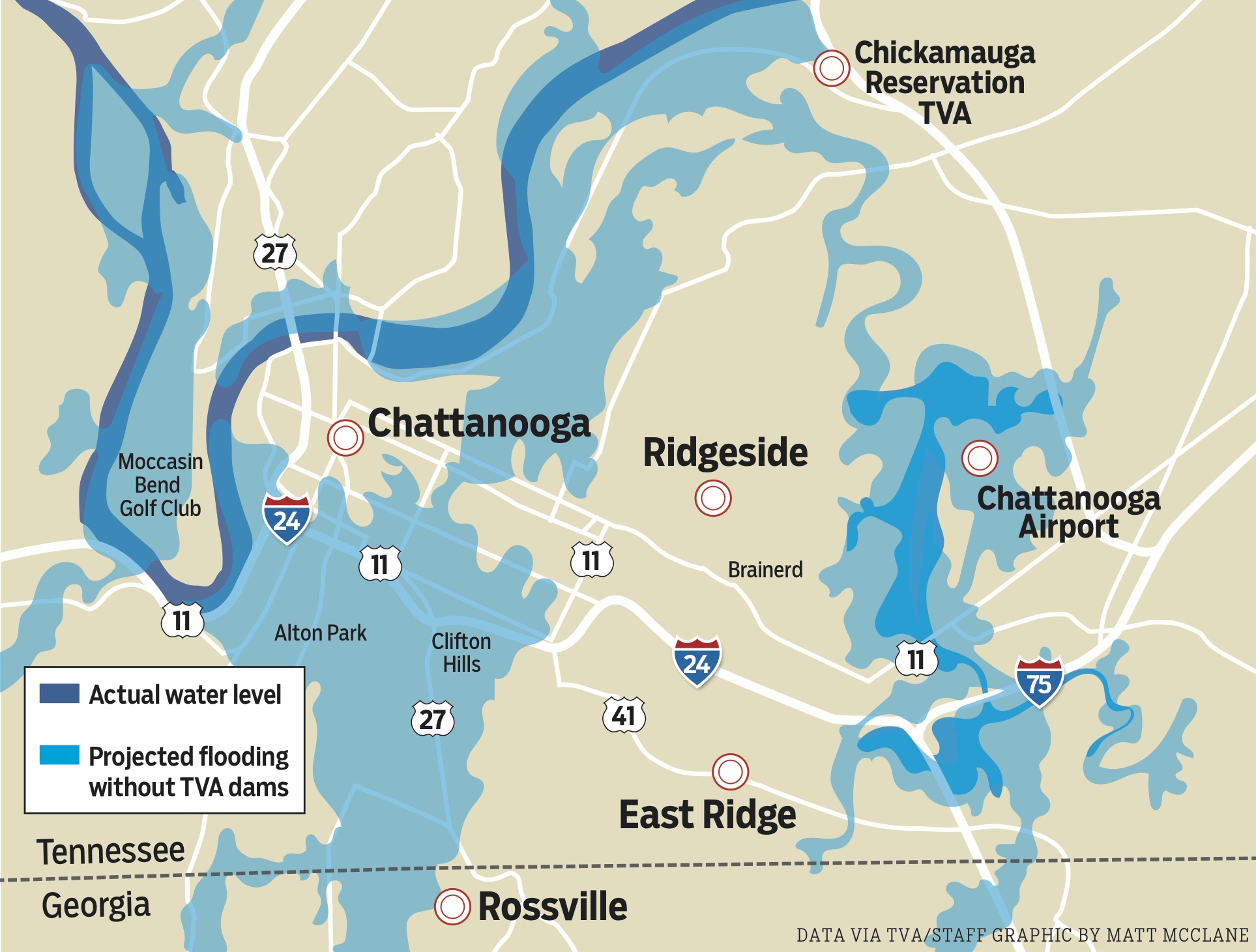 This illustration shows areas in the Chattanooga region that would have been flooded if not for the Tennessee Valley Authority's network of dams.
But it could be much worse if the dams and reservoirs erected on the Tennessee River over the past century were not in place. Maps prepared by TVA based on the projected effects of so much rain without TVA's dams indicate that most of the city's Southside and parts of North Chattanooga, the Amnicola Highway area and Brainerd, including the Chattanooga airport, would now be underwater if TVA wasn't holding back the heavy rains from last month.
Chattanooga is the drainage point in the Tennessee River basin for more than 20,000 square miles of East Tennessee, western Virginia, western North Carolina and North Georgia. Prior to the creation of TVA in 1933, Chattanooga was nearly completely underwater during major floods in 1917 and in the worst flood ever in 1867.
TVA estimates nearly 95 percent of the projected $1.6 billion in flood damage that would have occurred in the Tennessee Valley without its network of dams would have occurred in Chattanooga.
During an average year, TVA's reservoir operations avert approximately $300 million in flood damage. TVA estimates it has averted more than $8.6 billion in flood damage since it completed its first dam, Norris Dam, in 1936.
Even with TVA's dams, Chattanooga has suffered its worst floods when rains came in short periods of time. In 1973, the river was 13 feet higher than the level it reached last week, or 10 feet above flood stage. That flooded much of Brainerd, including the Eastgate Mall, and helped lead to the building of the Brainerd levee.
Last month, nearly 9 inches of rainfall runoff was recorded from the nearly 12 inches of rain that fell across TVA's seven-state region - triple the normal level. But the rains were spread over a 10-day period, allowing TVA to better control the river flow, Everett said.
"That much rain, on top of an already wetter than normal season, has really driven up runoff levels and raised our lakes, streams and river levels everywhere in the valley," he said.
So far this year, the Tennessee Valley has seen more than 17 inches of rain, more than double the normal precipitation for the period, following the record 67.01 inches of rain in the Tennessee Valley during 2018 - the highest yearly total in the 128 years that such records have been kept.
"With these persistent rains, we have very, very wet ground, so it doesn't take very much rainfall right now and the runoff will quickly fill creeks and streams," Everett said.
TVA took aggressive steps prior to last month's heavy rains to draw down its upstream reservoirs to maximize storage capacity on major lakes such as Fontana, Norris and Douglas.
TVA has been gradually releasing water from those lakes, keeping river levels high. But the most the agency can release without flooding downstream areas is a foot a day, Everett said. At that rate, it would take three or four weeks to get down to normal winter water levels.
Contact staff writer Dave Flessner at dflessner@timesfrepress.com or at 423- 757-6340.