Soddy-Daisy, Tennessee, residents continue to voice concerns about flooding of the city's creeks during major rains, with some speaking at four city commission meetings in the past two months.
Tiffany Winton, who lives along Little Soddy Creek, asked when the city plans to apply for grants from the Federal Emergency Management Agency to buy properties such as hers that are located in floodways within the city.
Earlier this month the city requested on its website and Facebook page that citizens affected by recent flooding along Little Soddy Creek, Big Soddy Creek and North Chickamauga Creek contact the city to provide information necessary to apply for a mitigation grant through FEMA.
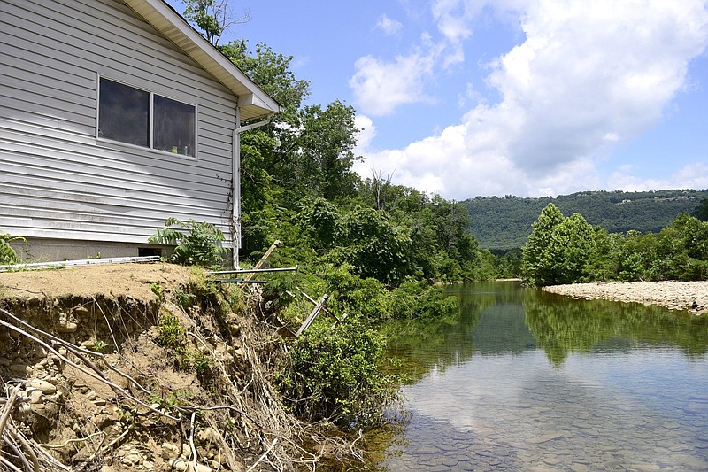
Some of the residents who have done so may not qualify for assistance through the grant, because the damage affected only their properties and not their homes, City Manager Janice Cagle said. One such property belongs to Pine Street resident Sandra Hayes, whose home is in imminent danger of falling into North Chickamauga Creek after the creek bed moved closer to her home during heavy rains on Easter Sunday.
Cagle said she hopes Hayes will qualify for another grant the city is applying for on her behalf that covers structures in imminent danger.
According to the 2019 Hamilton County, Tennessee Natural Hazards Mitigation Plan, buyouts of properties insured through the National Flood Insurance Program that are considered to be repetitive loss properties - which must have suffered flood damages on two or more occasions within a 10-year period in which the average cost to repair the damage exceeds 25% of the property's value at the time of each flood event - are among the costs the federal mitigation grants can cover. As of November 2018, Soddy-Daisy had four such properties, the document states.
How to find out if property is in a flood zone
Zoom into the area of the property on Hamilton County’s GIS map. You can choose from aerial views from 2016 or 2018 by clicking on “Base Map” at the bottom center of the screen. Click on “Layers” at the bottom left of the screen and then filter by clicking the plus sign next to the FEMA option. Click the box next to Floodway or 100 Year Flood (1% chance of flooding each year) to identify those areas on the map.
City Attorney Sam Elliott said the city of Soddy-Daisy is not responsible for purchasing homes endangered by creek erosion.
Elliott, the son-in-law of Dorris Bayless, whose home on Willow Creek Drive backs up to North Chickamauga Creek, said the creek rose by about 4.5 to 5 feet on Easter Sunday due to rains. He asked if the city is contracted with anyone to remove rock, silt and trees from the creek.
Mayor Geno Shipley said trees are the only type of debris the city is allowed to remove from the creek. Only trees that can be reached from the creek banks can be removed, added Public Works Director Steve Grant.
The city would need permits from the Tennessee Valley Authority, the Tennessee Department of Environment and Conservation and the Army Corps of Engineers to remove debris other than trees or operate equipment within the creek bed, Cagle said.
"Work in stream channels is typically conducted by the landowner," TDEC Deputy Communications Director Kim Schofinski wrote in an email.
She confirmed that the city may remove woody debris from the channel at any time without a permit from TDEC.
Alterations to stream channels, such as dredging or bank stabilization, would require coverage from TDEC under an Aquatic Resource Alteration Permit. Such a permit for maintenance activities allows up to 100 feet total of loose material, including rocks and sediment, to be removed around structures such as bridges and culverts without notification to TDEC, according to Schofinski.
History of erosion
Residents have expressed concern about floodwaters from the North Chickamauga Creek for decades. In a Dec. 1, 2000, Chattanooga Times Free Press story, residents said the creek threatens the bridge that runs over it on Dayton Pike, Soddy-Daisy Industrial Park and two high voltage TVA transmission towers.
At the time, Cagle told the newspaper that, since the city could not afford to protect all the homeowners and businesses along the creek, its biggest priority was protecting the bridge over North Chickamauga Creek on Dayton Pike.
Then-Mayor Bob Privett said the first bridge built there lasted 54 years before being washed away in a flood, but the second bridge, built in the mid-1980s, was showing signs of deterioration after just 14 years.
Although creek erosion and flooding have been longtime issues in the city, the frequency of flooding events and their severity have increased in recent years. Part of the issue can be attributed to record rainfall, said Craig Carrington, chief of the project planning branch of Nashville Division of the Army Corps of Engineers, who plans to meet with Cagle July 1 to look at the creeks, go over the tools the corps has available and see what solutions may apply to the flooding issues the city is experiencing with its creeks.
"Flooding can be a complex issue, so it can take some effort," Carrington said of identifying the cause of the flooding.
In 1998, the Corps of Engineers conducted a study at the request of Hamilton County and the city of Soddy-Daisy focused on ecosystem restoration and flood damage reduction in the North Chickamauga Creek watershed. The goal was to determine mitigation alternatives for the creek's severe stream bank erosion and flooding problems similar to those occurring today.
Probable causes for the stream bank's instability identified in the 1998 study included past catastrophic flooding, construction of the Dayton Pike bridge and past mining of cobble from the stream bed.
A major flood in September 2003 washed out Back Valley Road and caused several homes in the Willow Creek subdivision to lose 50 feet of property and cut away the foundations of several homes, rendering them unlivable, according to the 2019 Hamilton County Natural Hazards Mitigation Plan.
In September 2018, heavy rains caused widespread flash flooding, killing a woman on Back Valley Road and causing $1.3 million in damage and the erosion of Little Soddy Creek.
(READ MORE: Soddy-Daisy residents fear creek erosion puts their homes at risk)
Contact Emily Crisman at ecrisman@timesfreepress.com.