UPDATE at 3:28 p.m. on Saturday, March 27, 2021: A tornado watch has been issued for Grundy County, Tennessee, and Jackson County, Alabama, until 9 p.m. CDT Saturday night, according to WRCB-TV Channel 3.
_____
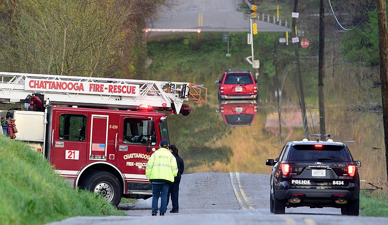
For Saturday night and early Sunday morning, forecasters are calling for another round of severe storms, damaging wind, renewed flooding and the chance for isolated tornadoes in the Chattanooga region, particularly counties to the west on the Cumberland Plateau.
Depending on how the system develops through the day, storms early on Saturday will be spotty and mostly north of Chattanooga in the afternoon and evening as the temperature tops out in the mid-70s, according to WRCB-TV Channel 3 meteorologist Paul Barys.
"It doesn't look like tornado outbreaks - it's not impossible - but it looks mainly like severe thunderstorms," Barys said of the National Weather Service's Storm Prediction Center outlook. "There's a potential for severe weather both days, mainly the first half of Sunday. Saturday night and Sunday looks like the worst."
Rainfall could total 1 to 2 inches over the weekend, he said, and as much as 2 to 3 inches over the next seven days.
"This flooding's going to continue," he said.
There has already been 9.31 inches of rain in March, weather service records show. Normal rainfall for March is 4.02 inches.
The two-day outlook issued by the storm prediction center Friday places Chattanooga near the edge of the zones for slight risk and marginal risk for severe weather in an area that comprises a population of almost 28 million in 11 states, including all but the northeast corner of Tennessee and all of North Georgia and North Alabama. An enhanced risk was predicted for 2.5 million people in West Tennessee, East Arkansas and Northwest Mississippi.
FIVE-DAY FORECAST
SaturdayCloudy, 70% chance of rainHigh 76 | Low 56SundayRain and storms early, 100% chance of rainHigh 68 | Low 64MondayMostly sunnyHigh 70 | Low 40TuesdayPartly cloudy, 20% chance of rainHigh 67 | Low 48WednesdayCloudy, 60% chance of rainHigh 66 | Low 52Source: WRCB-TV Channel 3 forecast as of 4:20 p.m. March 26, 2021
For folks planning to travel outside the Chattanooga area over the weekend, prediction center meteorologists said that isolated strong to severe storms are possible Saturday across the lower Mississippi through Tennessee Valley regions with all hazards possible including large hail, damaging wind and tornadoes. Other severe storms are possible across a portion of the Midwest with isolated damaging wind and large hail the main threats.
People shouldn't take Thursday's good fortune for granted because the Chattanooga region really dodged the severe weather bullet, Barys said.
"We got very lucky yesterday," Barys said Friday of Thursday's storms that left widespread flooding problems in the region.
"The reason we didn't get the severe weather is a lot of the heavier rain we got earlier in the day stabilized the atmosphere, cooled it down," Barys said. "And when you get the atmosphere stabilized, it takes something else to destabilize it, and when the warm front finally came in it was already after dark so it was just too late."
Had Thursday's warm front been three or four hours earlier, Barys said Friday's discussion about Thursday's storms might have been very different. He said the Newnan, Georgia, tornado was similar to last year's East Brainerd tornado that tore through Hamilton County and into Bradley County, leaving a path of destruction blocks wide.
Thursday's powerful storm system tore across the South, leaving six dead in Calhoun County, Alabama, where one large tornado cut a diagonal path across the community. As many as eight tornadoes might have hit Alabama through the day, John De Block, a meteorologist with the National Weather Service in Birmingham, told The Associated Press. Multiple twisters sprang from a "super cell" of storms that later moved into Georgia, he said.
In the Chattanooga region, Thursday's deluge dumped more than 2.5 inches of rain, causing flash flooding and road closures in the city and across the region where the ground was already saturated and creeks were overwhelmed. Despite the risk and deadly destruction in the Deep South, there was no major damage reported locally.
(READ MORE: Scientists study why Sand Mountain is tornado magnet)
Reports of tornado damage in Newnan - southwest of Atlanta - began coming in shortly after midnight. Trees were toppled and power lines downed, knocking out service by the local utility, AP reported. No fatalities were immediately reported there.
The bad weather stretched across the southern U.S., raising concerns of thunderstorms and flooding in parts of Tennessee, Kentucky and the Carolinas, according to AP.
Contact Ben Benton at bbenton@timesfreepress.com or 423-757-6569. Follow him on Twitter @BenBenton or at www.facebook.com/benbenton1.