The Benton MacKaye Trail Association is seeking congressional approval for the trail in Tennessee, Georgia and North Carolina to be designated a National Scenic Trail, which would boost the number of long-distance trails in the U.S. with that designation to an even dozen.
The almost 300-mile Benton MacKaye Trail traces an 82-mile path in Georgia and 206 miles more along the Tennessee/North Carolina border, including lands in the Cherokee National Forest in Tennessee, Chattahoochee-Oconee National Forest in Georgia and Nantahala National Forest in North Carolina, according to a news release from the trail association's board of directors.
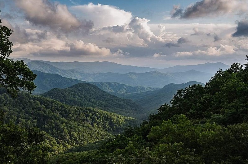
The Great Smoky Mountains National Park contains 93 miles of the Benton MacKaye Trail, making it the longest trail in the Smokies.
A National Scenic Trail designation would be timely, according to association president Ken Cissna.
"This year marks the 100-year anniversary of Benton MacKaye's treatise, 'An Appalachian Trail: A Project in Regional Planning.' That essay was the initial blueprint for the [Appalachian Trail]," Cissna said in a news release.
LEARN MORE
To learn more about the Benton MacKaye Trail Association and how to volunteer, go to the association website, bmta.org or write to jwfbrga@gmail.com to contact association vice president Joy Forehand.
The trail is named for visionary forester Benton MacKaye, known for his advocacy for the Appalachian Trail, according to the release. Today's route closely resembles MacKaye's proposed southern spur that extended the Appalachian Trail into north-central Georgia.
"I think Benton MacKaye would have been pleased with the trail today," Cissna said. "The striking vistas, rushing waterfalls, the iconic 'swinging bridge' and the pleasantly secluded forest pathways that wind through six wilderness areas as well as the Great Smoky Mountains National Park make the Benton MacKaye Trail a perfect candidate for designation as a National Scenic Trail."
Currently, the Benton MacKaye Trail and Appalachian Trail start at the same point on Springer Mountain in Georgia, and the two trails overlap at first, intersecting four times in the first 7 miles before going their separate ways at Long Creek Falls, officials said. Those portions are good choices for day hikes.

From Long Creek Falls, the trail heads north to cross the Toccoa River on the iconic swinging bridge in Fannin County, Georgia, before turning west to traverse numerous summits ranging from 2,500 to 3,500 feet in elevation, passing Fall Branch Falls through the Cohutta Wilderness Area and Big Frog Wilderness Area.
The trail eventually crosses into Tennessee at the remote Double Spring Gap in Polk County, Tennessee, followed by dramatic crossings over the Ocoee and Hiwassee rivers. The trail then ascends to the boundary ridge between Tennessee and North Carolina near Sandy Gap where hikers get 360-degree views.
After tracing solo paths for 180 miles, the trail meets up with its sibling Appalachian Trail near Fontana Dam then enters the Great Smoky Mountain National Park, sticking close to Fontana Lake. From there, it climbs to the top of Mount Sterling - the trail's highest point at 5,842 feet - and then descends to Big Creek in North Carolina, the trail's remote northern terminus about 5 miles south of Interstate 40.
TRAIL ASSOCIATION HISTORY
The Benton MacKaye Trail Association was founded in 1980. When the trail crossed the border into Tennessee in 1987, the association celebrated the completion of 93 miles of trail. The grand opening for the entire trail was held in 2005. Today, approximately 95% of the route is on public lands managed by either the U.S. Forest Service or the National Park Service. Only 15 miles currently remain on private land or as short road walks, according to association officials.
(READ MORE: The 10 best overlooks in the Chattanooga area to see fall colors)
According to the park service, the designation comes through a four-step process.
First, an amendment to the National Trails System Act must be passed requesting a feasibility study; second, the feasibility study must be conducted, the park service states in a description of the steps. Third, if the feasibility study recommends the trail be established, an act must be introduced seeking to add the trail to the National Trails System. Finally, once the trail is established, a comprehensive management and use plan that outlines the roles of the federal government and its partners must be created.
"Altogether this process has taken anywhere from six to 15 years," the park service states. "Because of this dialogue back and forth between Congress and the administrative agency over many years, a trail is most likely to succeed in this process if there is a strong, well-organized, citizen-based organization at work on behalf of the trail."
The Benton MacKaye Trail Association has 729 active members and has been around for more than 40 years. Richard Harris, the association's maintenance director for Tennessee and North Carolina, said members believe they have a good chance of getting the trail added.
Contact Ben Benton at bbenton@timesfreepress.com or 423-757-6569. Follow him on Twitter @BenBenton.
NATIONAL SCENIC TRAILS
National Scenic Trails are primarily non-motorized continuous trails and most extend for 100 miles or more. The routes traverse beautiful terrain and connect communities, significant landmarks and public lands.Appalachian Trail: 2,190 miles in Maine, New Hampshire, Vermont, Massachusetts, Connecticut, New York, New Jersey, Pennsylvania, Maryland, West Virginia, Tennessee, North Carolina.Arizona Scenic Trail: 800 miles in Arizona.Continental Divide National Scenic Trail: 3,100 miles in Montana, Idaho, Wyoming, Colorado, New Mexico.Florida National Scenic Trail: 1,300 miles in Florida.Ice Age National Scenic Trail: 1,000 miles in Wisconsin.Natchez Trace National Scenic Trail: 65 miles in Mississippi.New England Trail: 215 miles in Connecticut and Massachusetts.North Country National Scenic Trail: 4,600 miles in Michigan, Minnesota, North Dakota, New York, Ohio, Pennsylvania, Wisconsin.Pacific Crest National Scenic Trail: 2,650 miles in California, Oregon, Washington.Pacific Northwest National Scenic Trail: 1,200 miles in Idaho, Montana, Washington.Potomac Heritage National Scenic Trail: 710 miles in Washington, D.C., Maryland, Pennsylvania, Virginia).Source: National Park Service