(Editor's note: Second in a series)
Dr. James Livingood, professor of history at the University of Tennessee at Chattanooga, wrote about the Tennessee River in "Chattanooga Country, An Illustrated History," published in 1980. Below are excerpts:
"The site of Chattanooga occupies the southern limits of the Great Valley of East Tennessee, which in turn is the southern portion of a huge geological trough extending from Pennsylvania. The valley is framed by the Unaka Mountains to the east and the Cumberland Plateau to the west. The ancient Unakas - often popularly called the Great Smoky Mountains - are a constant barrier to easy travel.
"To one of vivid imagination the landscape appeared 'as if the Titans had plowed and forgotten to harrow it.' Only a few satisfactory passageways allowed for trails or roads 'across country" (east-west); most travelers and trade moved "up and down country.'
"Through this valley, crowded with geologic faults and burdened with folded, twisted, and compressed rock, flowed the Tennessee River. It gathered its waters from the hills of north Georgia, from tributaries rushing through deep wild gorges lost in the mountain fastnesses of North Carolina, and from long parallel streams with headwaters in Virginia. Although far from its mouth, the serpentine waterway was already a mature river with a wonderful timeless history. Like a true western stream, it was filled with shoals and reefs, gravel and sand bars, snags and sawyers.
"Boatmen using the old river constantly rounded bends and confronted new vistas. Early [European] mapmakers, too, had a difficult time finding a standard name for the stream. They called the waterway or sections of it Acansea Sipi, Cusatees, Hogohegee, Callamaco, Kallamuchee or Kallamak, Cherokee or Riviere des Cheraquis. Finally, the name Tennessee was chosen to honor a Cherokee town called Tunnissee, Tanase, Tenese, or some other spelling variation.
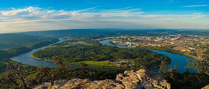
"Southwest of Chattanooga, near the entrance to a mountain gorge, the river passes a sentinel unique in its shape and grandeur. Like the many mountains nearby it has forested sides, cascading streams, a palisade crown and wears a variety of seasonal colors. But Lookout Mountain with its surroundings of mingled valleys stands out as a natural landmark which through the years has symbolized the silent strength, endurance, and beauty of nature. It is Chattanooga's logo.
"Opposite the promontory of Lookout Mountain, the Tennessee twists in every direction, outlining the shape of a giant Indian's moccasin.
"After the Tennessee River flows past Lookout Mountain, instead of continuing a southern course through a slight divide and on to the Gulf of Mexico, the contrary river chose to leave the East Tennessee Valley by cutting its way through the Cumberland Plateau.
"The mountain which Lookout faces across the Tennessee River gorge is the southern point of Walden Ridge, named for a Tennessee long hunter of pioneer vintage, possesses many of the same rough and irregular physical features as its companion to the south.
Read more Chattanooga History Columns
- Gaston: Paul John Kruesi was Edison's right-hand man
- Robbins: The old Richardson's house and the Civil War
- Gaston: James Williams was a man of the world
- Raney: Mason Evans, the 'Wild Man of the Chilhowee'
- Gaston: The legacy of Adolph Ochs endures
- Martin: Ed Johnson said, 'I have a changed heart,' the day before his lynching in Chattanooga on 1906
- Thomas: The inventiveness of Judge Michael M. Allison
- Moore: Chattanooga's first Chinese community
- Summers, Robbins: Chattanooga's Tuskegee Airman - Joseph C. White
- McCallie: The Civil Rights Act of 1964 says so!
- Gaston: John McCline's Civil War - from slave to D.C. parade
- Raney: Exploring Chattanooga businesses in the Green Book
- Elliott: Remembering the Freedmen's Bureau in Chattanooga
- Gaston: Nancy Ward was a beloved, respected Tennessean
- Martin: Prohibition - the noble experiment
- Elliott: 'A shameful, disgraceful deed': The destruction of the Sewanee cornerstone
- Gaston: Robert Cravens was ironmaster, Chattanooga area's first commuter
- Robbins: Dr. T.H. McCallie's Christmas 1863
- Robbins: Journalist writes of a trip to Missionary Ridge in 1896
- Summers, Robbins: Mine 21 disaster - gone but not forgotten
- Elliott: Collegedale incorporates to avoid Sunday 'blue laws'
- Gaston: 'Marse Henry' Watterson's journalism fame began in Chattanooga
- Robbins: Orchard Knob battle recalled in 1895
- Elliott: Chattanoogans joined in an 'orgy of joy and gladness' on Armistice Day, 1918
- Thomas: Noted service, speakers are marks of Rotary Club of Chattanooga since 1914
- Summers and Robbins: Remembering noted Tennessee author North Callahan
- Raney: 'I auto cry, I auto laugh, I auto sign my autograph'
- Gaston: Sequoyah's alphabet enriched Cherokees
- Robbins: A look at Sam Divine's life during the Civil War
- Robbins: Memories of a Confederate nurse
- Robbins: More notes from Bradford Torrey's 1895 visit to Chickamauga Battlefield
- Robbins: Journalist in 1895 details visit to Chickamauga Battlefield
- Elliott: Telephone exchange firebombing was distraction for grocery store robbery
- Gaston: Worcester brought Christ's message to Cherokee at Brainerd Mission
- Robbins: 1896 travel diary: 'A Week on Walden's Ridge'
- Gaston: Elizabeth Strayhorn, WAC Commandant at Fort Oglethorpe
- Robbins: The history of the Friends of Moccasin Bend National Park
- Moore: Do you own a Sears Roebuck home?
- Summers and Robbins: Camp Nathan Bedford Forrest in World War II
- Gaston: Hiram Sanborn Chamberlain remembered
- Elliott: Daisy the center of tile, ceramic manufacturing in Hamilton County
- Gaston: FDR inaugurates the Chickamauga Dam
- Summers, Robbins: Interned WWII Germans had it easy at Camp Crossville
- Elliott: A war correspondent on Lookout Mountain
- Gaston: Chickamaugas finally bury hatchet in Tennessee Valley
- Gaston: Chickamaugas in Chattanooga
- Robbins: The history of the Riverbend festival
- Raney: Sadie Watson, the first woman elected in Hamilton County government
- Moore: Remembering Chattanooga's Hawkinsville community
- Elliott: Welsh coal miners transformed Soddy after the Civil War
- Gaston: Chattanooga's best-kept secret
- Elliott: Cabell Breckinridge loses his horse
- Raney: Martin Fleming is the people's judge
- Gaston: The amazing career of Francis Lynde
- Martin: Hamilton County's Name Sake: Alexander Hamilton
- Summers, Robbins: The crosses at Sewanee
- Bledsoe: The fiery truce at Kennesaw Mountain
- Moore: Talented architect's life cut short by tragedy
- Rydell: Chattanooga's place in soccer history
- Robbins: Tennessee Coal, member of the First Dow Jones Industrial Average
- Raney: In the barber chair
- Lanier: Becoming the Boyce Station Neighborhood Association
- McCallie: John P. Franklin: Living history among us
- Barr: Chattanooga's first railroad: The Underground Railroad
- Summers, Robbins: Charles Bartlett was a Pulitzer Prize winner, Kennedy confidant
- Rainey: 'We have seen it'
- Elliott: Feinting and fighting at Running Water Creek and Johnson's Crook
- Gaston: The Spring Frog Cabin at Audubon Acres
- Raney: Wauhatchie Pike was moonshine motorway
- Robbins: Oakmont was home of venerable Williams clan
- Summers and Robbins: Rebirth of the Mountain Goat Line
- Elliott: Bad investments led to Soddy Bank failure in 1930
- Summers and Robbins: Pearl Harbor attack left football behind
- Gaston: Jolly’s Island namesake had long ties with Sam Houston
- Return Jonathan Meigs, Indian Agent
- Moore: Did you know about St. Elmo's other two cemeteries?
- Summers: Orme - Marion County's almost lost community
- Davis: Spooky revival at Sharp Mountain in 1873
- Robbins: The story of Longholm
- Raney: Women labored to help the U.S. win World War I
- Even in the city, the 'wheel' changed everything
- Murray: Confederate dilemma after Chickamauga
- J.B. Collins — Newsman extraordinaire
- Robbins: The Story of the Lyndhurst Mansion
- Chattanooga artist and wife lost on the Lusitania
- Chattanooga History Column: Battelle, Alabama and the Battelle Institute
- John Ross, a founder of Chattanooga
- Hamilton County casualties in World War I
- Chattanooga Power Couple
- 'Somewhere in France'
- The Ray Moss family
- Battery B from Chattanooga
- Ulysses S. Grant, Clark B. Lagow, and the Chattanooga Bender
- Songbirds Museum Timeline
- Hamilton County World War 1 roster
- The Soddy Girl and the Memphis Belle
- Blues icon Bessie Smith was the Empress of Soul
- Women's Army Corps at Chickamauga
- Emma Bell Miles' life at the top of the 'W'
- The Tivoli Wurlitzer is one of Chattanooga's priceless assets
- Chattanooga in struggle for freedom during Civil War
- October 1918, Chattanooga paralyzed by Spanish flu epidemic
- Eli Lilly and the Ditch of Death
- One hundred years ago, Chattanooga goes to war
- The legacy of Anna Safley Houston
- Harriet Whiteside was ahead of her time
- Southern Adventist University
- Chattanooga native's writings aided Civil Rights movement
- Zion College, Chattanooga's only African American College
- The North Shore's hidden past
- Mayme Martin -- Businesswoman and community leader
- Thomas Sim's epic struggle for freedom
- Top of Cameron Hill was price of rerouting interstate
- Cameron Hill has rich history
- Temperance movement included Harriman university
- The sweetest music this side of Heaven
- Conquistadors at Chattanooga
- Chattanooga and the 'General'
- Chattanooga's first Thanksgiving, 1863
- Chattanooga's greatest flood caught city unaware
- Opening the Cracker Line
- European trip in 1900 enlightens Sophia Scholze Long
- Sophia Scholze Long spoke out when others were silent
- Little South Pittsburg and its big silent movie stars
- Lot attendant recalls hottest job in Chattanooga
- Chattanooga's Forest Hills is final resting place for known, unknown
- Burritt College -- Pioneer of the Cumberlands
- Chattanooga's nicknames trace city's evolution
- The 25th annual meeting of the Tennessee Press Association
- Clemons Brothers Furniture Store
- The Short Life of the USS Chattanooga
- Ellen Jarnagin McCallie lived a truly remarkable life
- Dr. Jonathan Bachman was a revered city father
- Second guessing the Confederate failure on Missionary Ridge
- Nancy Kefauver, ambassador for the arts
- William Gibbs McAdoo kept his Southern roots
- Chattanooga's Secretary of the Treasury
- Howard Baker remembered as a statesman/photographer who snapped history
- Tivoli's last picture show
- The history of one of Chattanooga's oldest businesses
- Chattanooga's roller derby skaters
- Myths of Coca-Cola in Chattanooga
- Chattanooga's neighborhood grocery stores
- The tale of the Scottsboro Boys
- The people's history of Chattanooga
- Howard School is Chattanooga's reminder of Reconstruction
- Elevator operator, painter, mystery man: meet Rice Carothers
- Raulston Schoolfield made enemies amid his rise to power
- Website lets users peer into Chattanooga's past
- The flood of 1917
- Chattanooga's 'wickedest woman' buried at Forest Hills
- History of Cummings Highway
"Steep wooded slopes climb from the water's edge to a ring of cliffs of gray sandstone 1,000 feet overhead. Early rivermen called the 20 or more miles of this mountain stretch of the river the 'Narrows' or sometimes the 'Suck'; enthusiastic writers dubbed it the 'Valley of the Whirlpool Rapids,' while modern tour guides label it the 'Grand Canyon of the Tennessee.'
"When the first steamboat from the Ohio laboriously ascended the Tennessee River in 1828, an editor noted that passage through this stretch of water downstream from Ross's Landing had been 'impossible to be performed by any being or thing except the sturgeon and the catfish.'
"Ross's Landing - consisting of a decrepit ferry, a crude cabin for the ferryman, and a 'kind of shanty for goods' on the southern bank of the Tennessee River - marked the start of Chattanooga. About 1816 the small settlement began to serve the local trade and also became a transfer point for river traffic to roads running through a gateway to the south and on around the shoulder of the Appalachian Mountain. The Landing, surrounded by virgin forests, represented the business interests of the brothers John and Lewis Ross, youthful Cherokee Indians of mixed blood.
"Early in 1819 the United States purchased land north of the Tennessee River from the Cherokee, and on October 25 of the same year Tennessee created Hamilton County. For the next 16 years the river formed the boundary between an emerging white frontier and the Indian nation."
Frank "Mickey" Robbins, an investment adviser at Patten and Patten, is coordinator of this Local History series. Those wishing to contribute to the series may forward drafts to mickey@patteninc.com. For more visit Chattahistoricalassoc.org.