In the spring of 1865, as the light of the southern Confederacy was in its final flicker, Brig. Gen. Zealous B. Tower, inspector general of fortifications for the Union Military Division of the Mississippi, visited Chattanooga. At that point a backwater in a war that was coming to a conclusion, Chattanooga was still extensively fortified. Tower noted that "[t]he main line of works inclosing Chattanooga consists of four redoubts, four batteries, and about two miles of infantry parapet, and rests its flanks upon the Tennessee." There were two advanced forts outside of the main line, and three 100-pounder, rifled Parrott guns were emplaced on Cameron Hill. Tower approvingly wrote "[f]rom this high position they see over the defensive line in almost every direction."
Practically speaking, these fortifications can be characterized as installations on or around Cameron Hill, the inner line of which Tower wrote, and the two advanced positions, the most well-known of which, Fort Wood, was officially known as Fort Creighton, named in honor of a Union officer killed at the close of the Battle of Chattanooga. The other advanced position was in the area of Rossville Avenue (not Boulevard), south of today's Main Street. It was officially known as Fort Phelps, in honor of Col. E.H. Phelps, killed in the Union assault on Missionary Ridge, but is more commonly known as Fort Negley. A vertically mounted bronze cannon tube near 312 North Crest Road memorializes Phelps. Tower noted that Fort Phelps had 10 light artillery pieces, and Fort Creighton 14.
In the Cameron Hill area, more or less on the hill now occupied by AT&T Stadium, and incidentally the site of an earlier Confederate fort, was Redoubt Carpenter, named for a Union officer killed at Stones River. The redoubt had five light guns and one larger seacoast gun. Located on the south side of Cameron Hill in the approximate area of today's Gateway Avenue was Fort Mihalotzy, named for a Union officer killed in February 1864. Toward the river from Fort Mihalotzy, but still on the high ground that rose to the summit of Cameron Hill was Redoubt (or Battery) Coolidge, named for an officer killed at Chickamauga.
On the main line almost due south of Fort Mihalotzy was Fort (or Redoubt) Crutchfield, located on an "extension of Cameron Hill," later identified by historian Zella Armstrong as Terrace Hill. While its current location is unclear, it appears to have been located on the south end of today's Grove Street. To the southeast of Fort Crutchfield was Fort Lytle, named after a poet-soldier from Cincinnati who was killed at Chickamauga. Also known as the Star Fort, it was a large installation with 20-foot high walls and ditches of 10-15 feet. It was located in the area between 13th and 14th Streets, probably in the area of the aptly-named Fort Street.
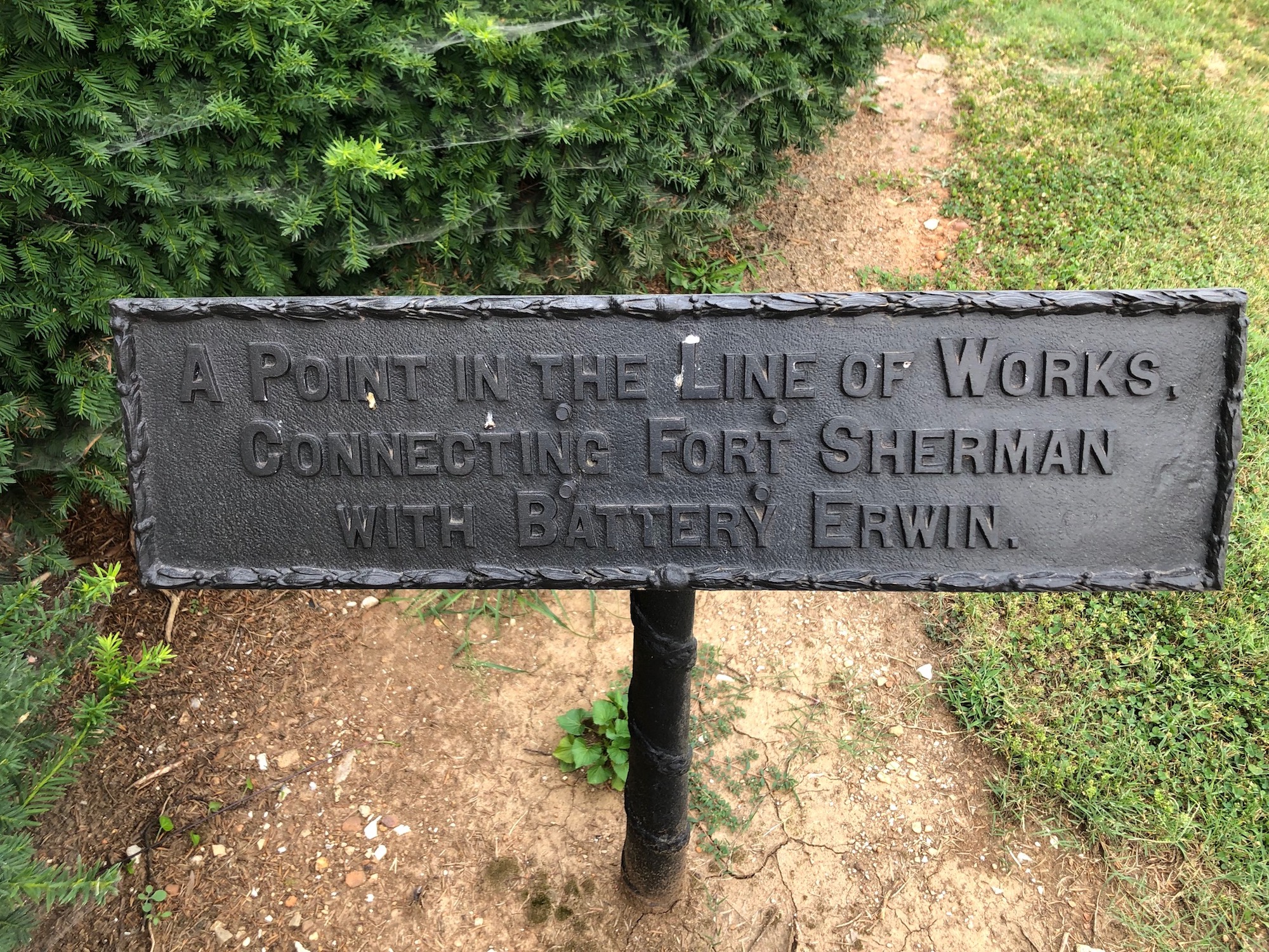
Progressing somewhat to the north, the inner line proceeded to Fort Jones, named for another Chickamauga casualty. Also known as the Stone Fort, the work was located in the general area of today's City Hall and the United States Bankruptcy Court. Stone from the partially constructed Sts. Peter and Paul Catholic Church was used to construct the work. Next on the line at the corner of today's East Eighth and Mabel streets was Battery Erwin, named for an officer killed in the Battle of Chattanooga.
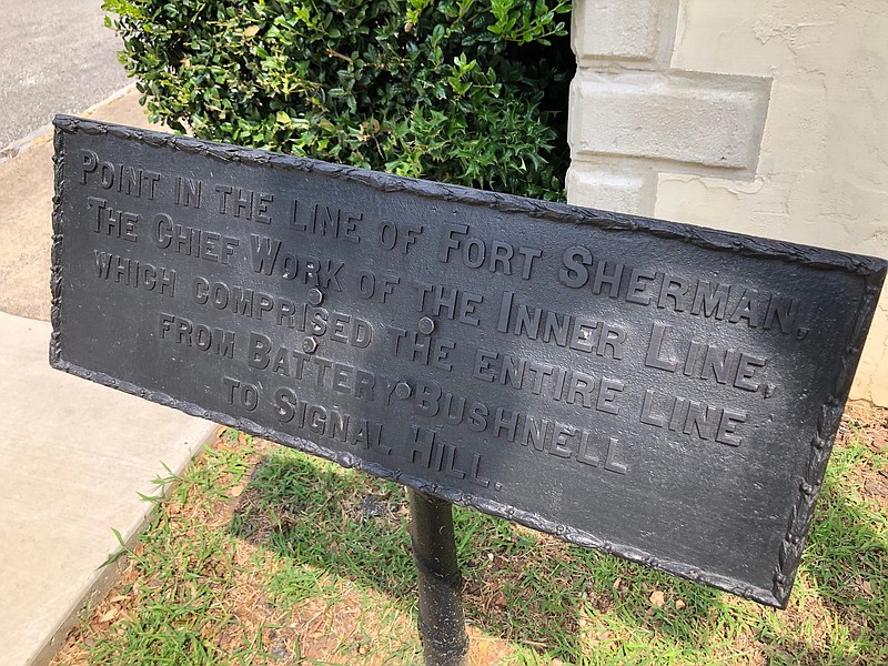
From there, the line went north again to Fort Sherman, within which were contained three separately named works. Fort Sherman itself occupied an area of two city blocks bounded by Fourth and Sixth streets and encompassed part of today's Walnut and Cherry Streets and the hill where the Brabson House remains. Like Fort Lytle, it had huge walls and deep ditches. The line from Battery Erwin attached to Fort Sherman at Lunette O'Meara, at Fifth and Houston streets. Recessed within Fort Sherman to the west of Lunette O'Meara was the heavily armed Redoubt Putnam. Finally, extending from Lunette O'Meara to near the Tennessee River was Battery Bushnell, located on today's appropriately named Battery Place.
In the 1890s, a committee was appointed to identify historical points in connection with the occupancy of Chattanooga by Federal and Confederate troops, and plaques were erected by the federal government. While few survive, those that do give a hint of how the Civil War temporarily changed the topography of Chattanooga.
Local attorney and author Sam D. Elliott is a former chairman and current vice-chairman of the Tennessee Historical Commission. Visit Chattahistoricalassoc.org for more information.