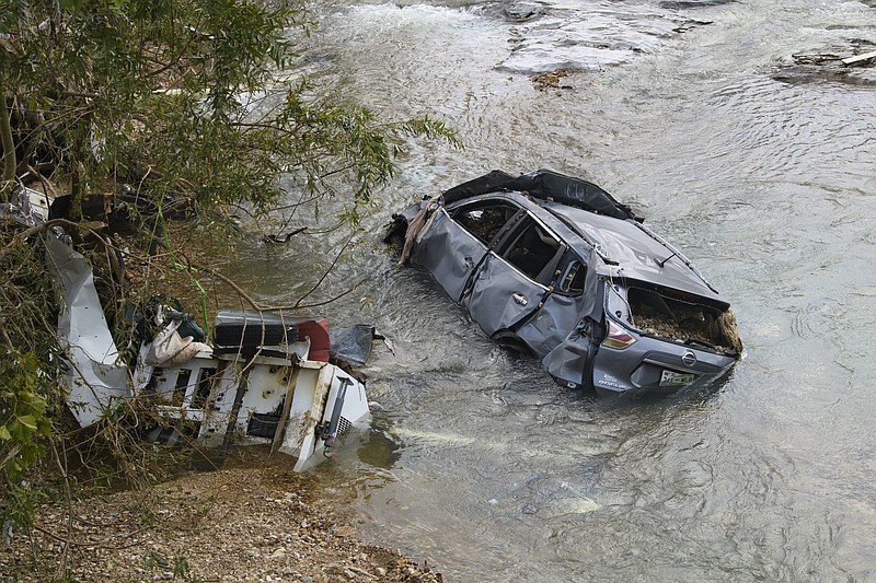
The rains that washed away lives and homes in Waverly, Tennessee, were not your grandfather's rains. Noah's maybe, but not your grandfather's.
Nor are they freak accidents. It's a grisly fact that while crews scour the banks of Waverly's abundant creeks for people still missing after Saturday's massive flood killed more than 20, these heavy, intense rains that are dumping on much of the Southeast are a new normal.
Climate scientists have warned for decades that global warming would cause more heavy rain. Now, with Earth almost 2 degrees Fahrenheit hotter than it was in the late 1800s, scientists are observing the trend in real time, according to National Public Radio.
James Everett, manager of Tennessee Valley Authority's River Forecast Center, said what happened in Waverly and the 300 square miles of watershed that drains its rural and gently rolling terrain where Middle Tennessee gives way to West Tennessee was an "extremely rare occurrence" and in an area where TVA flood control couldn't have a made a difference. There are no dams nearby.
"It was extremely heavy, intense rainfall over a somewhat relatively small area ... 17 inches of rainfall in a day and 15 of those inches occurred in about six hours. Even as somebody that has studied hydrology, it's hard to quantify that kind of rainfall," Everett said.
Can it happen here? And what would it mean for us? We'll let you ponder that thought for a moment while we make another point.
According to the most recent National Climate Assessment, the amount of rain falling during the heaviest storms in the Southeast increased by almost a third between 1958 and 2016.
Why is this happening? The short answer is because hotter air can hold more moisture, and it dries out soil, making it less absorbent. So old normals of heavy 5-inch rains are becoming 10-, 12-, 15- or 17-inch rains. That's what happened in Waverly - an area far away from any river dams and described by The New York Times as one where, "rivers and creeks run through the terrain like blood vessels in a body."
Does the last part of that description sound familiar?
By comparison, Everett said, the 2010 rainfall that so drastically flooded Nashville was about a 14- or 15 -inch event over several days and over a much larger geographic area.
Or, take for instance the February 2019 rains that made that month the wettest February in recorded history with totals sitting at 169% of the Tennessee Valley's average rainfall. Chattanooga alone saw 9.7 inches of rain in the month, and the Tennessee River reached a designated flood level of 30 feet in the city - or about twice its normal depth.
But that was from rainfall over a whole month; imagine if almost twice that much of rain fell in a matter of 24 hours. And imagine if it all fell in one 300-square-mile area - like say a space a little under half the footprint of Hamilton County. And imagine that it fell in an area between Nickajack Dam and Chickamauga Dam. In other words, imagine if it all fell in the geographic bowl of Chattanooga surrounded by mountains, ridges and hills.
Anything's possible with today's Mother Nature, but as of now we can't gauge exactly what that would mean for Chattanooga. Other than, as Everett put it, we would certainly see the Tennessee River and local creeks at flood stage.
How much at flood stage will take some testing - testing that TVA and the Weather Service normally makes. They will take all the rainfall data from around Waverly and "transposition" it by feeding the information into models for various areas - perhaps like Chattanooga.
TVA and the Weather Service do these flood study exercises of hypothetical rain events to be better prepared to warn the public and to control the water they allow to flow through the agency's 49 flood control dams.
Those dams helped avert an estimated $137 million of flood damages in Chattanooga following nearly 10 inches - twice the monthly "normal" - in March.
That's important because Chattanooga is the primary drainage path for rainfall across the eastern half of the Tennessee Valley, making the Scenic City the biggest beneficiary of the more than $10 billion in averted flood damage, thanks to the dams.
That said, if a Waverly-like rainfall were to make a bulls-eye of Chattanooga? Well, that's the reason for the flood studies.
The Tennessee Valley, so named because it is the watershed - the conduit - of the rainfall that either quickly or gradually flows to the Tennessee River from more than 40,875 square miles in six southeastern states, has now seen three straight years of record rainfall. That includes 2020, the wettest year in recorded history when TVA documented 70.36 inches of average rainfall throughout the valley.
Make no mistake, Mother Nature is in control, and she's charting new norms. That makes us especially glad these scientific flood studies by TVA and the Weather Service will continue to be "the norm." Not much else is normal these days.