
Friday, November 13, 2026Nov 13

Arthur zeroes in on NC coast for July 4 holiday

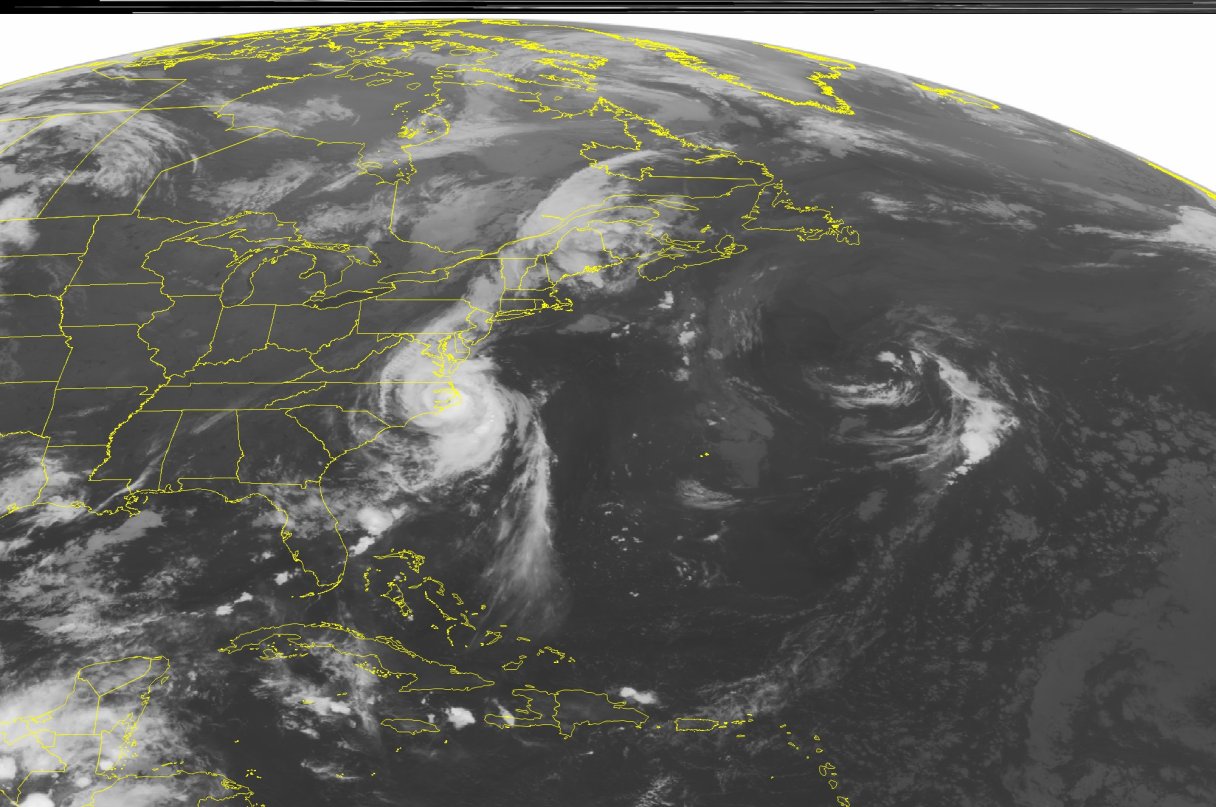
This NOAA satellite image taken Friday, July 4, 2014 at 01:45 a.m. EDT, shows Hurricane Arthur rolling across the Outer Banks of North Carolina, where hurricane conditions were reported early on the morning of the 4th.  Arthur will continue on a northeastward trek Friday into Saturday, producing flooding rain and damaging wind gusts over much of the coastal Northeast, in addition to the Canadian Maritimes.  Meanwhile, a cold front was responsible for a band of clouds and thunderstorms over the Northeast.  Much of the rest of the eastern U.S. was clear as high pressure was building into the region. (AP Photo/Weather Underground)
This NOAA satellite image taken Friday, July 4, 2014 at 01:45 a.m. EDT, shows Hurricane Arthur rolling across the Outer Banks of North Carolina, where hurricane conditions were reported early on the morning of the 4th. Arthur will continue on a northeastward trek Friday into Saturday, producing flooding rain and damaging wind gusts over much of the coastal Northeast, in addition to the Canadian Maritimes. Meanwhile, a cold front was responsible for a band of clouds and thunderstorms over the Northeast. Much of the rest of the eastern U.S. was clear as high pressure was building into the region. (AP Photo/Weather Underground) This NOAA satellite image taken Friday, July 4, 2014 at 01:45 a.m. EDT, shows Hurricane Arthur rolling across the Outer Banks of North Carolina, where hurricane conditions were reported early on the morning of the 4th. Arthur will continue on a northeastward trek Friday into Saturday, producing flooding rain and damaging wind gusts over much of the coastal Northeast, in addition to the Canadian Maritimes. Meanwhile, a cold front was responsible for a band of clouds and thunderstorms over the Northeast. Much of the rest of the eastern U.S. was clear as high pressure was building into the region. (AP Photo/Weather Underground)

KILL DEVIL HILLS, N.C. (AP) – The center of Hurricane Arthur was moving near North Carolina’s coast early Friday after slashing into the state’s barrier islands just ahead of Independence Day, forcing thousands to flee and much of the East Coast to shuffle holiday celebrations.

Arthur strengthened to a Category 2 storm with winds of 100 mph Thursday evening before passing over the southern end of the Outer Banks – a 200-mile string of narrow barrier islands with about 57,000 permanent residents. The islands are susceptible to high winds, rough seas and road-clogging sands, prompting an exodus that began Wednesday night.

The storm was moving northeast early Friday after turning slightly west late Thursday, which increased the threat to mainland communities from flooding, tornadoes and intense winds.

“We’re most concerned about flooding inland and also storm surges in our sounds and our rivers further inland,” North Carolina Gov. Pat McCrory said. More than 6,000 homes and businesses had lost electricity Thursday evening, but an evaluation of storm damage would have to wait until after the sun rose Friday, McCrory said.

Before the storm hit, tourism officials had expected 250,000 people to travel to the Outer Banks for the holiday weekend.