
Tennessee earthquake historyTennessee has been touched by “some of the most significant events in U.S. history,” according to the U.S. Geological Survey.* Aug. 17, 1865: The largest single earthquake in Tennessee history occurred outside of Memphis, near New Madrid, Mo. The quake threw down chimneys in Memphis and sent large waves through the Mississippi River. The shocks were felt through Missouri, Tennessee, Mississippi and Illinois. That quake registered at 5.0 magnitude.* 1811-1812: Three New Madrid earthquakes rocked up to 3.1 million square miles across Kentucky, Missouri and Tennessee – raising and sinking land masses and creating fissures over 80,000 square miles. The greatest of those tremors registered greater than 7.0 magnitude and created Reelfoot Lake in Northwest Tennessee.* Jan. 4, 1843: Severe earthquakes in Memphis registered an VIII intensity and up to 6.9 magnitude. The shocks were felt sharply in Nashville and as far away as Knoxville, although no significant damage was done in those cities.* March 28, 1913: Earthquakes centered in Knoxville cracked walls and toppled chimneys across 4,300 square miles in East Tennessee. The shocks were rated up to 5.9 magnitude.* Oct. 30, 1973: Cracks in the walls were reported at the University of Tennessee Medical Center in Knoxville after a 4.6 magnitude earthquake south of Knoxville sent rumbles throughout the region. Minor damage to walls, windows and chimneys occurred in Blount County.Source: U.S. Geological Survey
BE READYAhead of time:Secure your hot water heater, secure bookshelves to the walls and invest in cutoff valves for natural gas and water lines.• Put together an emergency preparedness kit.• Download the state’s Ready TN mobile app at www.tnema.org/ReadyTN/In case of an earthquake:• Stop what you are doing and get under something sturdy. Most injuries associated with earthquakes are from objects falling on peopleSource: Tennessee Emergency Management Agency
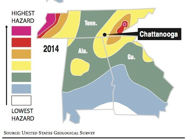
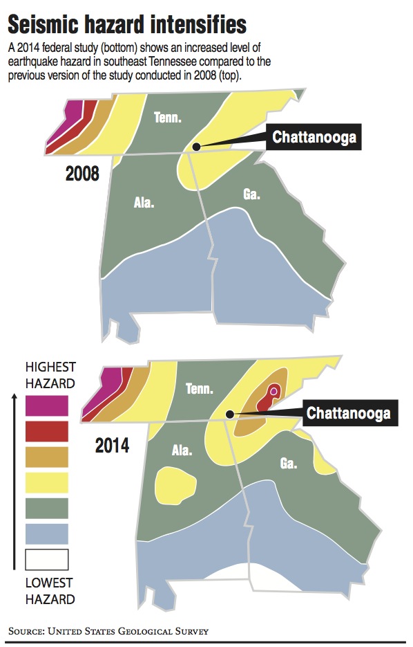
East Tennessee got a lot more colorful on the national seismic hazard map between 2008 and 2014.
More color signifies a higher earthquake hazard for a region that rarely registers notable seismic activity.
The U.S. Geologic Survey’s most recent map updates an area of Southeast Tennessee to include a patch of red, indicating it has been placed in the second-most hazardous tier out of seven that the USGS uses in its national map that is released every six years.