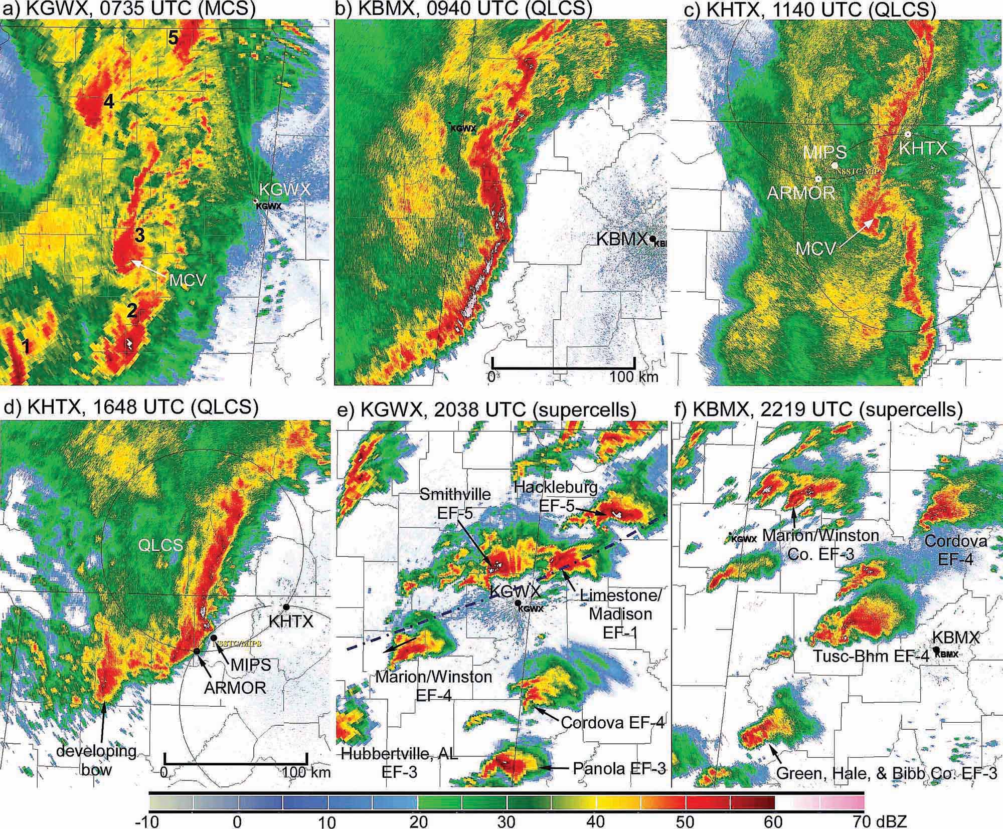
 A sequence of radar images from Columbus, Miss., Birmingham, Ala., and Hytop, Ala., from April 27, 2011, shows the variety of storm structures that occurred during this outbreak. Two images show storm supercells that either had active tornadoes or later developed tornadoes.
BY THE NUMBERS
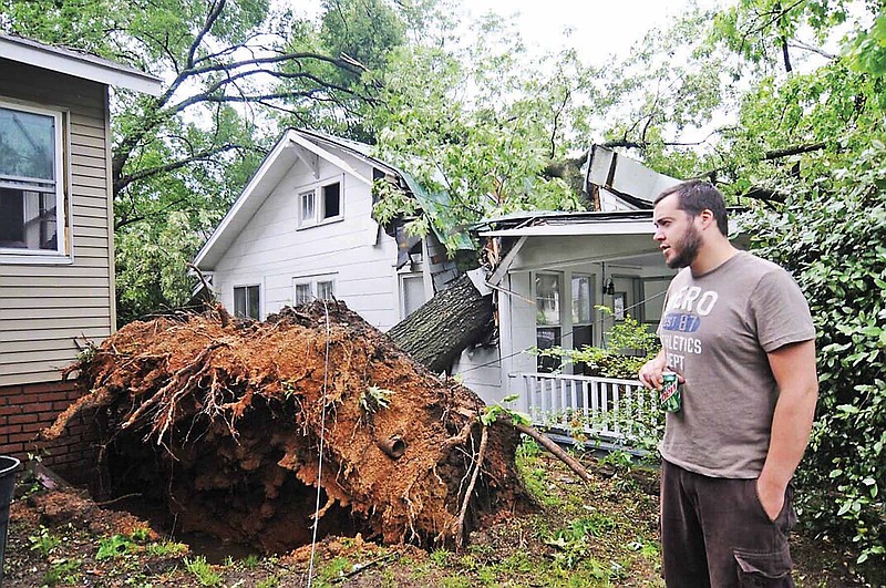
355: Number of tornadoes produced April 24-28, 2011, in the U.S. and Canada 199: Number of tornadoes touching down in Alabama, Georgia, Mississippi and Tennessee between 12 a.m. and 11:59 p.m. on April 27, 2011 324: Tornado-related deaths, including 238 in Alabama 4: Number of EF-5 tornadoes produced on April 27, 2011, in the South $11 million: Damage estimated over the four-day period across U.S. Source: University of Alabama in Huntsville Earth System Science Center
Warning of an approaching tornado was once like the notice Dorothy got in the movie "The Wizard of Oz" -- a line-of-sight, let's-get-out-of-here-right-now panicked reaction to a dark funnel cloud roaring on the horizon.
Weather technology was primitive early in the 20th century and still lacking more recently when the nation's most devastating tornado outbreaks since the turn of the last century occurred: In 1932, 1974 and 1994.
But on the day of the 2011 outbreak, scientists at the University of Alabama in Huntsville Earth System Science Center were ready to bring high-tech instruments to bear on the developing system drawing a bead on the South.
That day, a combination of weather instruments -- like the university's "Mobile X-band" radar and another mobile suite of upward-looking instruments -- started collecting data on the 2011 storms that researchers have been studying ever since.
So far, data collected the day of the April 27, 2011, outbreak provide findings that 90 percent of the supercell thunderstorms that day produced tornadoes, compared with the normal rate of 25 percent.
Data showed that a large-scale, counterclockwise circulation formed near an early-morning "squall line" in Northeast Alabama that produced 69 tornadoes, several of them EF-3s with damage paths a half-mile wide. Those storms hit Trenton in Georgia, Lookout Valley and East Ridge in Tennessee, and points in North Alabama that would be hit repeatedly throughout the day.
A weather balloon launched at the University of Alabama in Huntsville got detailed temperature readings from the surface into the upper atmosphere, and found a temperature profile that contradicts what weather models had predicted for storms of that type.
That finding "could change scientific understanding of the large-scale physics at work in major, violent storm systems," according to authors of a paper published in the Bulletin of the American Meteorological Society led by University of Alabama in Huntsville professor of atmospheric science Dr. Kevin Knupp. Knupp is also director of the school's new Severe Weather Institute, Radar and Lightning Laboratories.
The extent of cause-and-effect relationships of external factors influencing storm formation is still being debated, but factors like topography, gravity waves and the presence of a thermal boundary each interacted with different storm cells that day in 2011 at times when tornadoes were created or when existing tornadoes intensified, according to analysis of the data.
In some ways, the 2011 storms might correlate with the Palm Sunday 1994 tornado outbreak, Knupp said, "but in '94 NEXRAD [next-generation radar] was just coming out. Surface weather stations were fewer. We don't know much about that storm's characteristics."
Researchers believe what they're learning about the impact of topography, atmospheric waves of energy called "gravity waves," and roughness of the Earth's surface on the formation of tornado-producing storm systems could improve understanding and warning times.
"We can improve lead time and accuracy of tornado warnings," Knupp said Friday. "We can maintain a high probability of detection and reduce the false-alarm rate.
"That's the ultimate goal, to benefit society."
More 2011 Tornado coverage
Death toll from storms climbs to 78 in regionSchools scramble in storms' wakeRainsville death toll climbs to 32
And that only comes from analyzing and building on the foundation of data collected over the decades combined with what researchers in Alabama drew from 2011 and years since.
The circulation that formed near the squall line at Cullman, Ala., moved northeast over mostly forested, rolling hills through Marshall, DeKalb and Jackson counties in Alabama producing about 15 smaller tornadoes, mostly EF-1s and EF-2s, according to Knupp. The theory is that the rough ground surface played an important role in supporting tornado formation.
"We're looking at variations in topography that channel the air, that accelerate the air over ridges and change air flows," he said. "These are things that can significantly modify low-level inflow into the storms, in some cases setting up conditions that are favorable for tornadoes to form."
Now researchers are looking to use the data for other related topics.
"There's an emerging project that is just being formulated called Vortex-SE [southeast]," Knupp said. "One case study is not going to solve the problem. It's going to take dozens of case studies to really understand what's going on."
Also, the National Oceanic and Atmospheric Administration and the National Aeronautics and Space Administration are getting involved in the Vortex-SE project, Knupp said.
On Friday, Knupp was working on a proposal to NASA to get information from a new geosynchronous satellite to be placed in orbit that will have high-resolution space and time measurements of North America.
The satellite data can be combined with ground-based technology to give researchers a three-dimensional view of storm formation, he said.
"We're trying to connect to the latest technology for both the satellite platforms as well as ground-based platforms, so if there's a Vortex-SE program we're going to further build up our ground-based facilities here in Northern Alabama. That would be more radars and more atmospheric profiling systems ... that can measure variations over short time periods."
Those abilities could allow researchers to look deeper into the process of storm formation and give future researchers a growing foundation for more study, he said.
Contact staff writer Ben Benton at bbenton@timesfreepress.com or twitter.com/BenBenton or www.facebook.com/ben.benton1 or 423-757-6569.