
BY THE NUMBERS
The technology used in the Sand Mountain tornado study:› 13: Instrument-equipped vehicles› 5: Mobile radar systems› 4: Profiling systems using multiple instruments› 1: NOAA WP-3D Orion aircraft› Unknown number: Weather balloons laden with small instrument packagesSource: University of Alabama in Huntsville’s Severe Weather Institute, NOAA National Severe Storms Laboratory
WHAT IS THAT?
This spring researchers will deploy scores of weather balloons in Northeast Alabama in advance of approaching storm fronts to collect data. The balloons range in size from 18 to 36 inches in diameter and can climb to anywhere between 15,000 and 60,000 feet or more. Their most important work, however, with be lower to the ground, where tornadoes form. Some of the payloads — lightweight packages of instruments that would fit in a coffee cup — could end up in Tennessee and Georgia when the balloons burst. Researchers use GPS locators to retrieve the packages to download their data and reuse them. The packages also have phone numbers so anyone who finds one can call researchers to retrieve them.
Even though humans on Alabama's Sand Mountain go back at least 9,000 years, it probably never occurred to anyone to question why Mother Nature seems to deal out more tornadoes there than almost anywhere else in the area.
In the coming weeks, when storms are looming on the western horizon, mountain residents might see teams of scientists scurrying around the mountain. They're there to figure out what causes tornadoes to spawn there more than "almost any other place in North Alabama," said scientists from the University of Alabama at Huntsville's Atmospheric Science Department.
In fact, scientists were on Sand Mountain last Wednesday when two lines of storms delivered a one-two punch to the South with thunderstorms, heavy rain, hail and more than 40 tornadoes, officials in Huntsville said Friday.
Kevin Knupp, lead scientist on the research team, said mobile radar on Wednesday captured the formation of several thunderstorms, including one that intensified and produced a small tornado as the storm system moved northeast over the junction of the Tennessee-Georgia-Alabama state lines on the west side of Nickajack Lake.
That tornado was estimated to be an EF0 or EF1 with a path about 100 yards wide and more than two miles long, Knupp said.
"It intensified right over one of our radars on Sand Mountain," Knupp said. "That appeared to be a storm that was influenced extensively by the presence of Sand Mountain and perhaps Lookout Mountain, too."
Speaking in 2013 about the ongoing study, Knupp said he first noticed the effect of topography in 1989 when an EF4 tornado formed near Redstone Arsenal in Huntsville, and the same effect appeared later in other nearby storms. Northerly winds approaching a ridge like Sand Mountain accelerate as they squeeze up the slope then slow down suddenly when they drop off the other side of the mountain.
Thanks to more than $10 million in federal funding released in 2015 and 2016 to the National Oceanic and Atmospheric Administration, VORTEX-Southeast was able to launch the largest-ever study of tornadoes in the Southeast. UAH's Severe Weather Institute, Radar and Lightning Laboratories is the host for the study in Huntsville.
On Friday, Knupp said five radars were deployed on Sand Mountain - one that belongs to Knupp's group and four others belonging to other groups from 11 other research institutions working on the project. The main radar site is centered at Northeast Alabama Community College in Powell, Ala., with radar extending about 20 miles in each direction to the southwest and northeast.
Aside from radar, other instruments on the ground and onboard weather balloons measure vertical variations - that means changes from the ground up - in wind, temperature, humidity, cloud base, depth of clouds and depth of precipitation and other factors, Knupp said. The instruments and methodology complement each other to provide as clear a picture as possible of what's happening inside the storms and at the surface of the ground.
Researchers said that of 49 tornadoes that touched down in the Sand Mountain area in the last 10 years, 32 of them formed on top of the mountain.
"With Sand Mountain, we have strong evidence that something physical is going on up there," UAH doctoral student Tony Lyza said in a statement. Knupp said students are an important part of the effort and help with the field work.
Lyza said 16 of the 32 tornadoes that formed on top of the mountain did so within three miles of the northwestern edge.
"That's not a huge sample," Lyza admits, "but it's enough to make you question the possible physical processes that might impact those storm systems as they move atop that plateau."
Sand Mountain is the largest plateau on the Southern Cumberland Plateau and lies almost entirely in Alabama. Its northern tip extends just over the state line into Georgia. To the south, the mountain widens to about 15 miles or so and is home to more than two dozen small towns, mostly with populations well under 1,000 people.
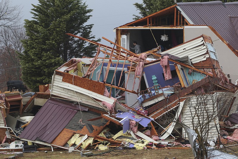
On April 27, 2011, a monster EF5 tornado killed 35 Sand Mountain residents as it plowed through DeKalb County. It was one of 62 tornadoes that struck Alabama that day. When it was over, 81 people in the Chattanooga region lost their lives to the deadly storms. Across the South the death toll was 316.
Another tornado outbreak on April 28, 2014 - the fourth-largest in Alabama's history - produced a storm that damaged or destroyed more than 50 homes on Sand Mountain but didn't take any lives.
Data from both those outbreaks are already part of the ongoing study, and researchers are also studying recently collected data from the November storms that struck the Sand Mountain towns of Rosalie in Jackson County and Ider in DeKalb, claiming three lives in Alabama and two more in Tennessee.
A traveler passing through most areas on Sand Mountain still can see the jagged, broken trees and forlorn foundations successive years of storms have left behind.
This spring, as many as 40 researchers or more will be working ahead of and during storms that hit Sand Mountain. Knupp said NOAA's Orion twin-engine turboprop aircraft will give researchers the ability to quickly move onboard instruments into position.
The multi-team project, launched March 8 and funded through May 8, will be the first time so many mobile, stationary and airborne instruments will be combined with high-resolution simulations using the National Center for Atmospheric Research's Weather Research and Forecasting Model, officials said.
The goal of the research, ultimately, is to be able to give more advanced warning of deadly storms, reduce false alarms and to make the warnings "site specific," Knupp said.
"The lead time, currently, is something like 15 minutes," he said. Ideally, meteorologists would like to be able to stretch the warning time out to an hour.
Until then, the study needs more data.
"For us, we'll be out there collecting data any time the weather is right," Knupp said.
Contact staff writer Ben Benton at bbenton@timesfreepress.com or 423-757-6569.