As the sun peeks through the clouds this morning, colder weather moves in as a 48-hour rainstorm shuttles out.
Flash floods were reported throughout Southeast Tennessee and Northwest Georgia on Tuesday morning, but most of the water has receded and cold air has flowed in.
"Right now, [projections show] December will be the coldest month of the year," said WRCB-Channel 3 chief meteorologist Paul Barys.
The sun should be out by midmorning and temperatures should stay in the 40s all day, he said.
And the chilly weather is going to stick around. Barys said to expect low temperatures into the holidays. Rain, though, shows no signs of returning until Sunday.
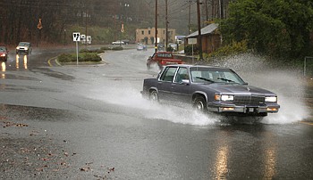
The rains that began Monday and lasted into Tuesday dumped more than 3 inches of precipitation on the Chattanooga area, flooding more than 10 roads in Hamilton County, police reported.
In surrounding Tennessee and Georgia counties, the rain caused small flash floods on roads, and tree limbs lay sprawled across several roadways. In Georgia's Catoosa County, 12 roads were closed Tuesday.
Although the water rose quickly, in some places it left just as quickly, officials said.
"About as quickly as [the flooding] formed across the roads, it's gone back down," said Bradley County Sheriff's Office spokesman Bob Gault.
Chickamauga Creek was expected to rise as high as flood stage at 18 feet throughout the night, according to the National Weather Service in Morristown, Tenn.
"It looks like it will be rising fairly high," said Weather Service forecaster Doug Schneider. "[But] it doesn't look like it will cause any widespread problems."
In Georgia, Fort Ogle-thorpe safety officials said they weren't worried about major flooding from the creek because experts reported the water wasn't expected to get above 16 feet.
While Northwest Georgia was in a tornado watch until 3 p.m. Tuesday, only a few fallen trees and limbs were reported in Walker and Catoosa counties.
Meanwhile, safety workers and police in Tennessee and Georgia spent Tuesday answering calls, helping to clear roadways and barricading flooded roads.

Schneider said much of the flash flooding could have resulted from leaves clogging drainage pipes.
On 23rd Street in Chattanooga, water covered the road, cutting off access to some side streets and trapping several cars. By mid-afternoon, two cars were still trapped in several feet of water at 23rd and Fourth Avenue.
One salesman in a local shop said he saw safety workers pull a family from one of the trapped cars and push another car to safety.
"The water was up high," said Lynn Lake, a worker at the Touba store off 23rd Street, pointing to a spot in the store's parking lot where the water had stopped.
As of 7 p.m. Tuesday, about 1,400 homes and businesses were without power in the Harrison and Highway 58 areas, the only areas in Hamilton County affected by the storms, said Lacie Newton, a spokeswoman for EPB. Power was back on within a couple of hours, she said.
In East Ridge, several yards and parking lots held large pools of water Tuesday, but no houses were reported to have flooded.
Most of the flooding had drained off roads by afternoon but scattered rain continued throughout the night.
Click here to vote in our daily poll: Did you experience any flooding on Tuesday?