The Chattanooga region is expected to experience severe weather Wednesday through Thursday morning as a major storm system approaches the area, according to our news partners at WRCB-TV.
There will be a strong chance for severe storms and even the threat of tornadoes through the overnight, especially west of Chattanooga, according to Paul Barys, chief meteorologist at WRCB.
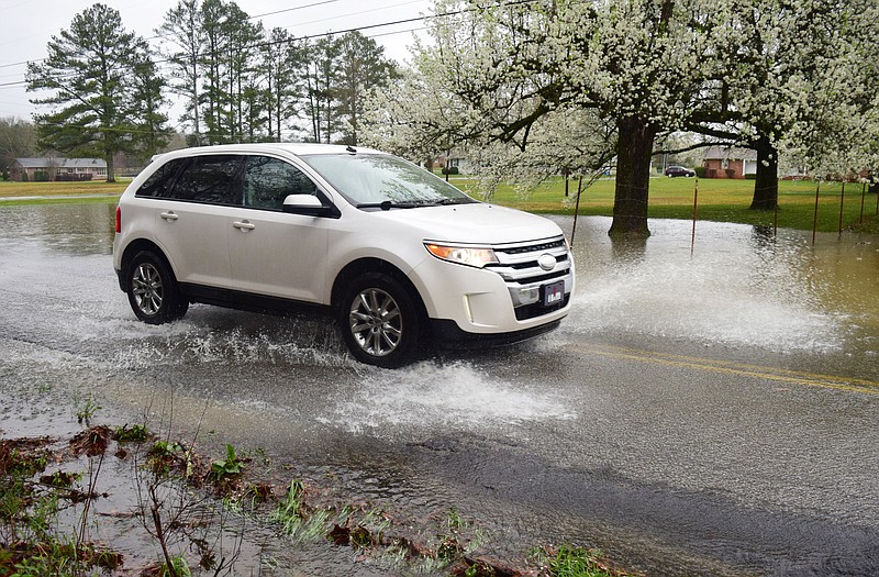
About 1 to 3 inches of rain is expected in the next 12-15 hours, according to WRCB. A round of thunderstorms is expected from 5 to 8 p.m. Wednesday night and new model data is suggesting supercells early Thursday around 4 to 7 a.m. If this occurs, a few tornadoes during this time will be possible.
A landslide apparently caused by heavy rains Wednesday evening closed the Bachman Tunnels on Ringgold Road, according to a news release from East Ridge Fire Chief Mike Williams.
A flash flood watch has been issued through Thursday morning for Bledsoe, Bradley, Hamilton, Marion, McMinn, Meigs, Polk, Rhea and Sequatchie counties in Tennessee and Catoosa, Dade, Murray, Walker and Whitfield counties in Georgia.
Hamilton County and Whitfield County schools have announced a two-hour delayed start Thursday morning. Bradley County and Cleveland City schools announced they will be closed Thursday because of the expected inclement weather. Georgia Northwestern Technical College will delay opening until 10 a.m. Thursday.
The "Significant Wind Risk" has also shifted to include more Tennessee Valley counties. This includes Franklin, Jackson, DeKalb, Chattooga, Walker and Dade counties. A Significant Wind Risk means wind gusts of 74 mph or greater will be possible.
While some parts of Tennessee and Georgia use tornado sirens, Hamilton County does not, citing topography, a local nuclear plant and the expense. To get alerts on a smartphone, enable emergency alerts under "notifications." Otherwise, use a NOAA weather radio or follow the National Weather Service.
According to the Chattanooga Department of Transportation, the following roads are closed or have reduced lanes due to flooding from Wednesday rains:
Province/Airport
2745 Cannon Avenue
510 Ely Road
7804 East Brainerd Road
Davidson Road at Gunbarrel
5500 Miller Drive
Morris Hill at East Brainerd
Cannon at 28th
1020 W. 37th Street
3500 5th Avenue
Bass Road at East Brainerd
Shallowford Road at Jenkins
7600 Davidson Road (new flood gates activated)
420 Shawnee Trail
1900 Dodson Avenue
2911 Hamill Road
100 Central Drive
4401 N. Choctaw Drive
Gunbarell At Commons
5830 Brainerd Road
East Brainerd Road at Anderson
2600-2800 McCallie Avenue
(How a deadly tornado snuck up on some Hamilton County residents, not others)
(When night terrors are real: Tennessee leads nation for twisters in the dark)
A wave of storms pounded the Deep South on Wednesday, leaving a trail of splintered trees and damaged buildings, and forecasters said still stronger ones were on the way with the potential for massive tornadoes, downpours and hail the size of baseballs.
While nearly 16 million people in the Southeast could see powerful storms, the Storm Prediction Center said, a region of about 3 million stretching from southeastern Arkansas and northeastern Louisiana across Mississippi into Alabama was at high risk for big twisters that stay on the ground for miles, straight winds up to 80 mph (129 kph) and destructive hail.
Possible tornadoes knocked down trees, toppled power lines and damaged homes in rural Chilton County and the Alabama communities of Burnsville and Moundville, where power was out and trees blocked a main highway.
"Downtown Moundville got it. Some roofs and stuff got taken off houses," said Michael Brown, whose family owns Moundville Ace Hardware. and Building. "There's a lot of trees down. I guess it had to be a tornado; it got out of here pretty fast."
Additional damage was reported in Louisiana, Tennessee and Mississippi, where video showed an apparent tornado at Brookhaven. High winds blew down signs and and trees in northeast Texas, and hailstones the size of baseballs were reported near the Alabama-Mississippi line, the weather service said.
More than 70,000 homes and businesses were without power from Texas to Alabama, and radar showed additional storms moving across the region as initial cleanup work began.
Storms were possible all the way from northern Texas in the west to northern Illinois and as far east as the Carolinas, the forecasters said, and the weather service issued more than 50 tornado warnings in Alabama, Arkansas, Texas, Mississippi and Oklahoma. Tornado watches included parts of seven states.
Dozens of schools systems in Alabama, Louisiana and Mississippi canceled classes, switched to online learning or dismissed students early, and Mississippi State University moved to virtual teaching because of the potential for danger at its campuses in Starkville and Meridian.
Large vaccination clinics where hundreds of people an hour can get shots without leaving their vehicles were canceled in Alabama, Mississippi and Tennessee. In the Mississippi capital of Jackson, state employees were warned to head to stairwells if they hear weather sirens. Near Birmingham, labor organizers canceled an outdoors event at an Amazon facility where workers are voting on union representation.
At least two waves of storms were likely, forecasters said, and the worst might not hit until a cold front passes overnight.
"The biggest question is how strong to severe these storms are going to be and if they're going to be tornadic right off the bat," said Gary Goggins, a forecaster with the National Weather Service office for Birmingham.
Gov. Kay Ivey placed Alabama under a state of emergency, and communities across the South used social media to share the location of tornado shelters. Dozens of people gathered in a gymnasium that was opened as a shelter in Tuscaloosa, where more than 50 people died in a twister during a weather outbreak that occurred 10 years ago next month.
In Jackson, Tennessee, officials said a civic center and the regional airport would be open for residents seeking shelter.
Elsewhere, the severe weather threat led the South Carolina Senate president to caution senators to state home Thursday while urging staff to work remotely for their safety. House Speaker Jay Lucas said that chamber would meet less than an hour Thursday to take up routine motions to be able to debate a budget next week - then adjourn.
"If you are in a situation where it is perilous that you come I'm asking you not to come," Lucas said. "If you can come, give us a quorum and do these few things we need to do, we will be out of here in a hurry."
Nearly all of South Carolina is under a moderate risk of severe storms with forecasters also saying there could be a few strong tornadoes. The unusually dire forecast led a number of the state's school systems to call off in-person classes Thursday and have students and teachers meet online.