The remnants of Hurricane Ida, which made landfall in Louisiana Sunday on the 16th anniversary of Hurricane Katrina, will bring heavy rain to the Chattanooga area with the potential of flooding, an isolated tornado threat and wind gusts at 20-30 mph.
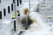
Ida left scores of coastal Louisiana residents trapped by floodwaters and pleading to be rescued Monday while making a shambles of the electrical grid across a wide swath of the state in the sweltering, late-summer heat.
One of the most powerful hurricanes ever to hit the U.S. mainland weakened into a tropical storm overnight as it pushed inland over Mississippi with torrential rain and shrieking winds, its danger far from over.
The Chattanooga region can expect 2-4 inches of rainfall from Monday night through Wednesday morning, most of which will fall on Tuesday. However, there are some areas that could get as much as 6 or 7 inches, though that would be the exception.
The heaviest rain from Ida will be west of Interstate 75, including Chattanooga. Most of the region's counties are under a flash flood watch for Tuesday into Wednesday, according to our news partner WRCB-Channel 3.
Chattanooga will be on the east or "dirty" side of the storm system, so the area will experience a combination of steady rain and broken waves of storms. A few storms may become strong to severe with damaging wind gusts and isolated quick spin-up tornadoes. Tropical system tornadoes are typically weaker, but happen very quickly.
(READ MORE: Chattanoogans with New Orleans ties worry for family, friends)