(Editor's note: First of two parts)
The Chattanooga flood of 1973 generated questions about historical preparedness. How did much of Chattanooga find itself "under water"? It's a story from several decades earlier that includes detailed plans, high price tags and an interruption of debate when attention was diverted by the surprise attack at Pearl Harbor.
How does the story unfold?
A comprehensive study by J.L. Schley, major general and chief of engineers, United States Army, authorized by the Flood Control Act of 1938 and titled "A Survey of Chattanooga, Tennessee and Rossville, Georgia," was submitted to the secretary of war in September 1939. The secretary then provided a copy of the report to the speaker of the House of Representatives along with a recommendation that Congress appropriate the required funds.
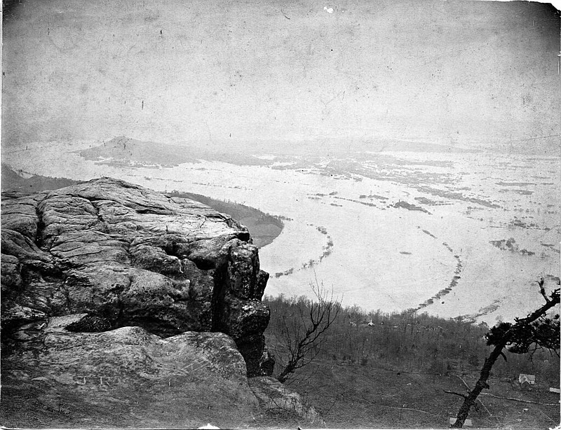
The study described the region as "Chattanooga, the largest city on the Tennessee River Basin," and its neighbor to the South, Rossville, as "vital to the nation's economy." Engineers noted that mountainous topography created a serious threat for flooding due to the rapid runoff following heavy rains. In carefully examining the city's footprint, the report determined that "Chattanooga's flood stage was 30 feet." And while a 30-foot crest seemed too high to be a real threat, the report documented that the flood stage from 1875 to 1938 had been reached or exceeded 71 times, with the largest deluge having occurred in March 1867, when the flood waters crested at 57.9 feet.
The documented report proved what many civic and manufacturing leaders in the region feared. Chattanooga was vulnerable. They had hoped that a high flood crest was no longer probable, given the modifications being made to the river's natural flow.
Instead, the chief engineer reported that given Chattanooga's large manufacturing and business base, a repeat of the 1867 flood level was possible and would result in the flooding of about 8,000 important acres. The increased risk was possible given the ongoing development occurring on the mountains and in the region, altering the landscape. If a repeat of 1867 occurred in 1939 Chattanooga, the quickly rising waters would impact "the larger part of the business district, the manufacturing district, the railway stations and yards, and the greater part of the railroad tracks within the city." The only "improvements for flood control ... consist of low levees constructed by the Works Progress Administration for the protection of the municipal airport." At the time of the U.S. Army Corps of Engineers report, the Norris Dam on the Clinch River had been completed, the Hiwassee and Chickamauga Dams were under construction, and the Watts Bar Dam had just been approved by Congress -- and still the danger threatened Chattanooga.
So, how did the U.S. Army's Corps of Engineers suggest "lessening the threat"?
The plans provided for the "construction of levees and flood walls with necessary sewer and drainage structures, pumping plants, diversion of creeks and railroad and street modifications." The levees and walls would be designed to protect the city "against the maximum flood of record with a freeboard of 5 feet ... . The proposed works, in combination with the construction of reservoirs now in progress or contemplated" would protect the city.
Three separate projects were proposed: 1) the main Chattanooga and Rossville project, 2) the St. Elmo project in the western part of the city, and 3) the Brainerd and municipal airport projects east of the city. The total projected cost was $20 million with federal funding suggested at $16.6 million, leaving state and local governments responsible for about $3.5 million. The chief engineer recommended "that the United States construct the local flood-protection works at Chattanooga and Rossville ... in accordance with the plan ... subject to certain conditions of local cooperation." A consulting report from the Board of Engineers for Rivers and Harbors accompanied the findings and was submitted by the speaker of the House to Congress, suggesting the construction of levees and flood walls first. Work could begin shortly after Chattanooga provides "without cost to the United States Secretary of War ... all lands, easements, and rights-of-way necessary ... ."
Secretary of War Harry Hines Woodring's letter to Congress reminded elected representatives that destructive floods "upsetting orderly processes and causing loss of life and property, including the erosion of lands, and impairing and obstructing navigation, highways, railroads and other channels of commerce ..." constitute a menace to national welfare and security.
So, how soon would construction begin? The national response to Pearl Harbor prevented early attention to work in Chattanooga.
Linda Moss Mines, Chattanooga and Hamilton County's official historian, is also vice chair of the Coolidge National Medal of Honor Heritage Center. For more information, visit Chattahistoricalassoc.org.