The Tennessee River Gorge is a 26-mile canyon formed by the Tennessee River as it cuts through the Cumberland Plateau west of Chattanooga. The canyon separates Signal Mountain and Walden's Ridge on the northern side from Raccoon, Elder, and Aetna mountains on the southern. The entrance to the canyon begins at Moccasin Bend, where the Tennessee River takes a sharp turn north past Williams Island.
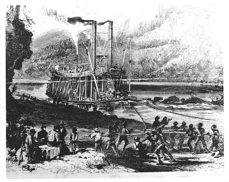
The gorge was once notorious for many navigation obstacles including eddies, sandbars, rocks and snags. Several whirlpools and shoals developed colorful names such as the Skillet, the Pan and the Pot. In 1781, Thomas Jefferson wrote about the most dangerous whirlpool, the Suck, in his "Notes on Virginia": "Above the Chickamogga towns is a whirlpool called the Sucking pot, which takes in trunks of trees or boats and throws them out again half a mile below."
Indian trade paths were established through and around this gap in the mountains to circumvent the treacherous waters. One of the busiest was the Great Indian War Trail, or Great Indian Warrior's Path, which ran from Virginia to Alabama. Locally, it passed through Ooltewah, crossed Chickamauga Creek in Brainerd and Citico Creek at its mouth, and connected to the Cherokee town of Runningwater west of the gorge. Other local trails led to the Cisca and Saint Augustine Trail, which ran from Florida to Middle Tennessee or connected with the Tennessee River, Ohio and Great Lakes Trail, which began in north Georgia.
For centuries, Native Americans, including Cherokees, established their villages at the intersection of these transportation routes. This pattern of habitation over 12,000 years encompassed Moccasin Bend and Williams Island. In the early 1800s, Scottish trader Daniel Ross and his Cherokee son John Ross established businesses at or near Ross's Landing just up river from Moccasin Bend. Another Cherokee, John Brown, established a ferry on the Bend to serve the busy crossroads. Chattanooga shares a rich history with the famed peninsula located at the gateway to the Tennessee River Gorge.
In the early 19th century, Euro-American settlers in Tennessee, northwest Georgia and southwestern Virginia sought access to markets in the Gulf of Mexico and the Caribbean Sea. They already shipped cotton and whiskey down the Tennessee, Ohio, and Mississippi rivers to New Orleans. Once arrived, they disassembled their boats, sold the wood, and traveled home via the Natchez Trace.
At the time, the Tennessee River offered only a long, dangerous route for small flatboats and keelboats. With the advent of steam-powered vessels, Tennesseans pursued river improvements to allow these craft, which carried greater cargoes, to travel through the Tennessee River Gorge. Steamboats heretofore avoided this section of the river and instead operated separately, above and below Moccasin Bend with its treacherous gorge.
In 1831, the Tennessee legislature established a Board of Internal Improvements. At its first meeting in January 1832, the new board asked President Andrew Jackson to place Col. Stephen Harriman Long, an army civil engineer, in charge of improving the Holston-Tennessee rivers system from Knoxville to the Alabama state line. His many assignments included designing bridges for the Baltimore and Ohio Railroad and scouting the Missouri River to recommend locations for forts to control the Indian trade. For the 1819 Missouri expedition, Long designed and built one of the first sternwheelers made in the United States, the Western Engineer. Long was also chief engineer for the Western and Atlantic Railroad, which ran from the Tennessee River at Chattanooga to Atlanta.
Long chose two civil engineers and three from the Corps of Topographers to accompany him to Tennessee. The lands on the south side of the Tennessee River, from the mouth of the Hiwassee to the state line, still belonged to the Cherokees. The colonel never sought their permission to conduct the survey. During the study, one of the civil engineers, Philip R. Van Wyck, a graduate of West Point, drowned trying to swim through the Boiling Pot.
Long recommended more than $58,000 in improvements, including establishing warping facilities, straightening and deepening the channel, and constructing a sluice and dam. The work took several years, but by 1835 steamboats were able to travel from Alabama to Knoxville when water levels allowed. The river upgrades aided commerce on the Tennessee River and its tributaries and also made the Cherokee settlement at Ross's Landing more attractive to white settlers as an important transportation hub. The improvements also enabled use of steamboats in the Cherokee Removal of 1838.
Vicki Rozema is author of "Voices from the Trail of Tears." For more on local history, visit chattahistoricalassn.org.