(Editor's note: Since Congress passed federal legislation creating the Moccasin Bend National Archeological District in 2003, progress on transforming the iconic peninsula into a unique national park has come in fits and starts. Elected leaders are grappling with the possible relocation of Moccasin Bend Mental Health Institute and police firing range, for starters. Today the Times Free Press begins a multi-part series examining the historic significance of the peninsula and its potential as a cultural, economic and recreational asset like no other.)
Moccasin Bend was a crossroads, a place on the Tennessee River of great importance through human history.
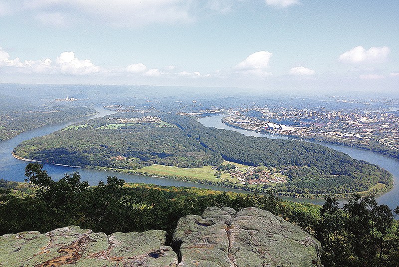
The first few hunter-gatherers, the Paleo Indians came to this region at the end of the last ice age, about 13,000 to 10,000 years ago, followed game and camped on the high banks of the Tennessee River, which flooded 60 to 80 feet higher than today's river. This spot continued to be used for thousands of years for its vantage point and rich bottomlands. Walking that high riverbank today gives commanding views over the lower terraces of the modern floodplain where a succession of Archaic, Woodland and Mississippian Indians lived.
As the climate and river flow changed, the Archaic Indians (10,000 to 2,500 years ago) adapted. They took advantage of seasonal abundances, gathering in the choice floodplain sites in the summers. In the winters, they disbanded into smaller groups to hunt in the mountains that surround Chattanooga.
During the Woodland period (2,500-1,100) increasing populations encouraged people to consolidate into villages, tend crops, build more permanent homes, use ceramic vessels and to trade for exotic goods. Conch shells, for example, were hard to come by the farther you lived from the Gulf of Mexico, and copper scarce the farther you lived from Michigan, where it could be found on the surface. These among other scarce goods had become important ceremonial items, often interred with the dead in burial mounds typically on higher ground than their settlements, as was the case on Moccasin Bend.
Woodland-era houses dotted the floodplain terraces of Moccasin Bend, and several burial mounds have survived between the Moccasin Bend Mental Health Institute, adjacent parking lots and roads.
Across the mental health campus, construction has disturbed and displaced the shallower traces of the Indian presence, but the deeper elements, corner posts of houses, storage pits and burials, were typically deeply dug and likely survive even beneath buildings. And, if soil was being added to the site by flooding, over thousands of years of use, then earlier houses, hearths and artifacts would be buried and preserved even deeper.
The intensive agriculturalists of the succeeding Mississippian era (1,100 — 400 years ago) farmed and lived along the bend. By the time the De Soto, Pardo and De Luna expeditions came through the region, there were two villages side-by-side at the heel of the bend. Typical of the time, they likely were encircled on all sides but the river by high post walls in defense against raids from rival chiefdoms. An area outside the walls would have been kept clear as a kill zone. Beyond that were agriculture fields to feed the population and store enough surplus to carry them through the winter, possible droughts and sieges.
These villagers were Muskogean-speaking people, their houses were rectilinear, the walls of wattle and daub, and semi-subterranean for warmth in the winter and cool in the summer, and a trench around the outside to channel away rain. A long porch roof extended from the doorway, providing a "summer house" for light and fresh air living. Glass beads and other Spanish trade goods found their way to the twin villages on Moccasin Bend, as no doubt so did the devastating European diseases that ravaged the Native American populations of first contact and caused their economies and powerful chiefdoms to collapse. Prior to 1600 the villages were abandoned and their survivors made their way south, to the Coosa and Tallapoosa Rivers. There they consolidated with others to become the Upper Creek.
From about 1600—1770 there were very few people in the Chattanooga area and no known major settlements or villages.
The Cherokee lived in the Blue Ridge mountains, but with pressure from westward movement of the Europeans from the Atlantic coast, the Cherokee expanded into the void left in the Tennessee Valley by the collapse and the exodus of the Muskogean and Yuchi speakers.
Colonial settlers followed and competed for land with the Cherokee, who by a succession of treaties, surrendered land for assurance that aggression by settlers would stop, were forced southward. There were many acts of resistance, most openly that of Dragging Canoe and his followers who effectively prevented travel though this section of the Tennessee River for a period during the American Revolution.
Before the final treaty and the Cherokee removal, a Cherokee named Richard Brown had a farmstead of 640 acres on Moccasin Bend. His son John ran Brown's Tavern on the far shore and Brown's Ferry at the "Federal Road" that crosses Moccasin Bend. General R.J. Meigs had negotiated by treaty with the Cherokee that this ancient road become a Federal Road, guaranteeing white settlers passage through Cherokee Territory.
In the removal several groups of Cherokee were taken around the bend by boat, and others crossed the neck of the Bend by the Federal Road and then the river at Brown's Ferry under escort.
Many of the Cherokee owned African American slaves who accompanied them to Oklahoma on the Trail of Tears. Before about 1850, when the railroads came into use, the Browns Ferry Federal Road Trace was a principle means of moving goods and African American slaves between the upper and lower South. One slave, Jacob Cummings, working a farm on the bend, took an old Indian canoe and crossed the river and made his way north to freedom and became an agent in the Underground Railroad.
The Civil War earthen gun emplacements for the Union batteries in the hills at the tip of Moccasin Bend are the best preserved of any across the battlefields of Chickamauga and Chattanooga. These guns kept the Confederates from fielding their forces across the shoulder of Lookout Mountain to challenge the armies of Hooker and Sherman as they poured into Lookout Valley.
Browns Ferry was captured by Grant's engineers in a night raid, and a pontoon bridge was erected, which the armies of Hooker and Sherman crossed to break the siege of Chattanooga and join Grant to rout the Confederates from Missionary Ridge, turning the tide of the American Civil War.
Lawrence Alexander is a well-known archaeologist and consultant. Jay Mills is a board member of National Park Partners.