GEORGETOWN, Tenn. - A few hundred yards from the intersection of Tennessee State routes 58 and 60 in Meigs County lies the original roadbed of a portion of the Cherokee Trail of Tears, a segment state historians believe deserves a national place of honor and distinction.
The Tennessee Historical Commission voted in January to nominate the site to the National Register of Historic Places for its role in one of America's darker moments when the Trail of Tears traced a path of despair for the Cherokee from their homeland in Tennessee, Georgia and North Carolina to the Indian Territory in modern-day Oklahoma.
The Georgetown property belongs to Greg Vital, who owns hundreds of acres in the area of the trail and finds it deeply moving to think about what the trail means to the history of the area.
"It is very overwhelming when you think of it in the context of what occurred there [184] years ago," Vital said Wednesday in a telephone interview. "The sections of the Trail of Tears in most cases have completely disappeared because of progress and development and the fact that they were long and narrow and stretched a long ways from East Tennessee and North Carolina all the way to Oklahoma."
There is no time to waste in making moves to preserve important cultural sites so the story of the Cherokee can be told using the earth as an exhibit, said Vital, who also is a member of the state House of Representatives.
"This along with several other stretches that were not recovered, that were not disturbed or were set aside help us tell that story and remember the importance of individual freedoms and liberties, but also recognize the resilience of the Cherokee Nation and the Cherokee people," Vital said.
Vital noted there are a number of other segments of the Trail of Tears and other historic American Indian sites already preserved in the area.
But this one, he said, might not have been identified if not for his battle with the Tennessee Valley Authority a few years back after the federal utility announced plans to build a $300 million power control facility in Meigs County that would have built power lines over privately owned rural farmland.
"During the TVA land dispute and eminent domain battle that I had several years ago, it became evident that this was adjacent to that new TVA right-of-way, so we've worked to protect it permanently," he said.
Vital said he and TVA have since worked together in a settlement to reduce the size of the utility's power lines to avoid disturbing area farmland and historic Native American sites in the path of the original design.
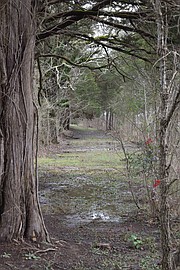
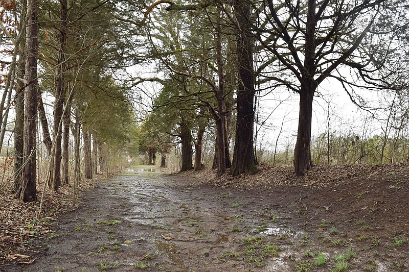
The nominated property is a 0.12-mile segment of a transportation route once known as the Georgetown Road, according to National Register of Historic Places registration records. The now-abandoned roadbed was used by some Cherokee detachments to reach Blythe Ferry to cross the Tennessee River en route to Indian Territory on the northern route of the Trail of Tears in 1838, records state.
The segment runs parallel to Tennessee Highway 60 and is defined by embankments measuring between 6 inches to 3.5 feet high. The roadbed segment is 13 feet to 27.5 feet wide, records state.
Today, the roadbed is occasionally used by local Cherokee for memorial Trail of Tears walks and retains enough integrity to meet characteristics for requirements for roadbeds under application rules.
(READ MORE: Red Clay celebrates the Cherokee: A people "all of one fire")
The Cherokee were given until May 23, 1838, to leave voluntarily, but only about 1,681 left before the deadline, nomination documents state. After the deadline passed, Gen. Winfield Scott and 7,000 federal troops and state militia forcibly gathered the Cherokee from their homes and took them through a network of forts and camps on their way to one of three main emigrating depots - Fort Cass in present-day Charleston, Tennessee; Ross's Landing in present-day Chattanooga; and Fort Payne, Alabama.
On July 23, 1838, the Cherokee Council petitioned the United States government to postpone removal until fall, when the weather was more favorable to long-distance travel and to give the Cherokee control of the remainder of their removal. Permission for both was granted provided the Cherokee stay encamped at the emigrating depots until travel resumed in late August, documents state.
Over the summer, the Cherokee remained encamped in unfavorable conditions and makeshift shelters at the emigrating depots. The majority of Cherokee were encamped at Fort Cass, the largest of the emigrating depots, which also served as the headquarters of Scott and the entire removal operation, according to documents.
Cherokees' living conditions at the camps were poor, and shelters at the camps typically ranged from nothing to tents to makeshift structures built from logs, thus many were exposed to the elements, documents state.
(READ MORE: Damage in 2014 to Trail of Tears in Coker Creek, Tenn., now repaired)
When the Cherokee resumed the march at the end of summer, the first leg of the journey for the more than 9,000 encamped throughout the Fort Cass Emigrating Depot was to travel to Blythe Ferry and cross the Tennessee River, thus officially leaving their ancestral homeland behind, documents state.
"Matthew Rhea's 1832 map of Tennessee shows one road, known as the Georgetown Road, connecting 'Walker's,' the former home of John Walker, Jr., which served as a landmark, through the Georgetown community and to Blythe's Ferry, near the junction of the Hiwassee and Tennessee rivers," documents state.
Other roads in the area are also noted in the nomination, but an 1862 map of the area on file at the Tennessee Division of Archaeology shows the road coming out of Charleston and crossing Mouse Creek, then dipping southward toward Georgetown, documents state.
"It intersects with a road that runs between 'Walker's' - probably John Walker's farmstead near what is now the Burlington Heights subdivision of Cleveland - and Blythe's Ferry," nomination documents state. "The present-day Georgetown road follows the same approximate course."
The Eastern Band of Cherokee Indians Tribal Historic Preservation Office in Bryson City, North Carolina, said the nomination is a win for the preservation of Cherokee cultural history from its most traumatic time.
"We absolutely support the preservation and interpretation of the routes that were used for the forced removal of the Cherokees and others in the area," historic preservation specialist Stephen Yerka said Friday in a telephone interview. "We think it's an important part of not only Cherokee heritage, but for North American heritage and global heritage really; this is one of those things we should not forget. The significance of this can't be understated."
People have to take interest in preservation before human expansion overtakes the most sensitive sites, he said.
"We appreciate Mr. Vital's care-taking, as well," Yerka said. "We do often have to rely on private landowners to protect these sites, and we're always very glad when we can work with folks like this."
The Tennessee Department of Transportation launched a widening project on the Cleveland end of Highway 60 in October, but Vital, who is a member of the House Transportation Committee, said future phases of the widening work heading west won't disturb the site.
Three additional prospects for 2022 were also nominated, according to commission officials.
Those nominees include, in Rutherford County, the Benevolent Cemetery, an African American cemetery established in 1897 containing 1,500 graves; in Knox County, Emory Place Historic District, which was nominated for its variety of styles and forms of architectural trends in the mid-1800s; and Howell Nurseries, another Knox County site also known as the Knoxville Botanical Garden and Arboretum, chosen for its landscape and architectural features dating back to the early-1900s, according to commission officials.
Contact Ben Benton at bbenton@timesfreepress.com or 423-757-6569. Follow him on Twitter @BenBenton.