Read more Chattanooga History Columns
- Gaston: Paul John Kruesi was Edison's right-hand man
- Robbins: The old Richardson's house and the Civil War
- Gaston: James Williams was a man of the world
- Raney: Mason Evans, the 'Wild Man of the Chilhowee'
- Gaston: The legacy of Adolph Ochs endures
- Martin: Ed Johnson said, 'I have a changed heart,' the day before his lynching in Chattanooga on 1906
- Thomas: The inventiveness of Judge Michael M. Allison
- Moore: Chattanooga's first Chinese community
- Summers, Robbins: Chattanooga's Tuskegee Airman - Joseph C. White
- McCallie: The Civil Rights Act of 1964 says so!
- Gaston: John McCline's Civil War - from slave to D.C. parade
- Raney: Exploring Chattanooga businesses in the Green Book
- Elliott: Remembering the Freedmen's Bureau in Chattanooga
- Gaston: Nancy Ward was a beloved, respected Tennessean
- Martin: Prohibition - the noble experiment
- Elliott: 'A shameful, disgraceful deed': The destruction of the Sewanee cornerstone
- Gaston: Robert Cravens was ironmaster, Chattanooga area's first commuter
- Robbins: Dr. T.H. McCallie's Christmas 1863
- Robbins: Journalist writes of a trip to Missionary Ridge in 1896
- Summers, Robbins: Mine 21 disaster - gone but not forgotten
- Elliott: Collegedale incorporates to avoid Sunday 'blue laws'
- Gaston: 'Marse Henry' Watterson's journalism fame began in Chattanooga
- Robbins: Orchard Knob battle recalled in 1895
- Elliott: Chattanoogans joined in an 'orgy of joy and gladness' on Armistice Day, 1918
- Thomas: Noted service, speakers are marks of Rotary Club of Chattanooga since 1914
- Summers and Robbins: Remembering noted Tennessee author North Callahan
- Raney: 'I auto cry, I auto laugh, I auto sign my autograph'
- Gaston: Sequoyah's alphabet enriched Cherokees
- Robbins: A look at Sam Divine's life during the Civil War
- Robbins: Memories of a Confederate nurse
- Robbins: More notes from Bradford Torrey's 1895 visit to Chickamauga Battlefield
- Robbins: Journalist in 1895 details visit to Chickamauga Battlefield
- Elliott: Telephone exchange firebombing was distraction for grocery store robbery
- Gaston: Worcester brought Christ's message to Cherokee at Brainerd Mission
- Robbins: 1896 travel diary: 'A Week on Walden's Ridge'
- Gaston: Elizabeth Strayhorn, WAC Commandant at Fort Oglethorpe
- Robbins: The history of the Friends of Moccasin Bend National Park
- Moore: Do you own a Sears Roebuck home?
- Summers and Robbins: Camp Nathan Bedford Forrest in World War II
- Gaston: Hiram Sanborn Chamberlain remembered
- Elliott: Daisy the center of tile, ceramic manufacturing in Hamilton County
- Gaston: FDR inaugurates the Chickamauga Dam
- Summers, Robbins: Interned WWII Germans had it easy at Camp Crossville
- Elliott: A war correspondent on Lookout Mountain
- Gaston: Chickamaugas finally bury hatchet in Tennessee Valley
- Gaston: Chickamaugas in Chattanooga
- Robbins: The history of the Riverbend festival
- Raney: Sadie Watson, the first woman elected in Hamilton County government
- Moore: Remembering Chattanooga's Hawkinsville community
- Elliott: Welsh coal miners transformed Soddy after the Civil War
- Gaston: Chattanooga's best-kept secret
- Elliott: Cabell Breckinridge loses his horse
- Raney: Martin Fleming is the people's judge
- Gaston: The amazing career of Francis Lynde
- Martin: Hamilton County's Name Sake: Alexander Hamilton
- Summers, Robbins: The crosses at Sewanee
- Bledsoe: The fiery truce at Kennesaw Mountain
- Moore: Talented architect's life cut short by tragedy
- Rydell: Chattanooga's place in soccer history
- Robbins: Tennessee Coal, member of the First Dow Jones Industrial Average
- Raney: In the barber chair
- Lanier: Becoming the Boyce Station Neighborhood Association
- McCallie: John P. Franklin: Living history among us
- Barr: Chattanooga's first railroad: The Underground Railroad
- Summers, Robbins: Charles Bartlett was a Pulitzer Prize winner, Kennedy confidant
- Rainey: 'We have seen it'
- Elliott: Feinting and fighting at Running Water Creek and Johnson's Crook
- Gaston: The Spring Frog Cabin at Audubon Acres
- Raney: Wauhatchie Pike was moonshine motorway
- Robbins: Oakmont was home of venerable Williams clan
- Summers and Robbins: Rebirth of the Mountain Goat Line
- Elliott: Bad investments led to Soddy Bank failure in 1930
- Summers and Robbins: Pearl Harbor attack left football behind
- Gaston: Jolly’s Island namesake had long ties with Sam Houston
- Return Jonathan Meigs, Indian Agent
- Moore: Did you know about St. Elmo's other two cemeteries?
- Summers: Orme - Marion County's almost lost community
- Davis: Spooky revival at Sharp Mountain in 1873
- Robbins: The story of Longholm
- Raney: Women labored to help the U.S. win World War I
- Even in the city, the 'wheel' changed everything
- Murray: Confederate dilemma after Chickamauga
- J.B. Collins — Newsman extraordinaire
- Robbins: The Story of the Lyndhurst Mansion
- Chattanooga artist and wife lost on the Lusitania
- Chattanooga History Column: Battelle, Alabama and the Battelle Institute
- John Ross, a founder of Chattanooga
- Hamilton County casualties in World War I
- Chattanooga Power Couple
- 'Somewhere in France'
- The Ray Moss family
- Battery B from Chattanooga
- Ulysses S. Grant, Clark B. Lagow, and the Chattanooga Bender
- Songbirds Museum Timeline
- Hamilton County World War 1 roster
- The Soddy Girl and the Memphis Belle
- Blues icon Bessie Smith was the Empress of Soul
- Women's Army Corps at Chickamauga
- Emma Bell Miles' life at the top of the 'W'
- The Tivoli Wurlitzer is one of Chattanooga's priceless assets
- Chattanooga in struggle for freedom during Civil War
- October 1918, Chattanooga paralyzed by Spanish flu epidemic
- Eli Lilly and the Ditch of Death
- One hundred years ago, Chattanooga goes to war
- The legacy of Anna Safley Houston
- Harriet Whiteside was ahead of her time
- Southern Adventist University
- Chattanooga native's writings aided Civil Rights movement
- Zion College, Chattanooga's only African American College
- The North Shore's hidden past
- Mayme Martin -- Businesswoman and community leader
- Thomas Sim's epic struggle for freedom
- Top of Cameron Hill was price of rerouting interstate
- Cameron Hill has rich history
- Temperance movement included Harriman university
- The sweetest music this side of Heaven
- Conquistadors at Chattanooga
- Chattanooga and the 'General'
- Chattanooga's first Thanksgiving, 1863
- Chattanooga's greatest flood caught city unaware
- Opening the Cracker Line
- European trip in 1900 enlightens Sophia Scholze Long
- Sophia Scholze Long spoke out when others were silent
- Little South Pittsburg and its big silent movie stars
- Lot attendant recalls hottest job in Chattanooga
- Chattanooga's Forest Hills is final resting place for known, unknown
- Burritt College -- Pioneer of the Cumberlands
- Chattanooga's nicknames trace city's evolution
- The 25th annual meeting of the Tennessee Press Association
- Clemons Brothers Furniture Store
- The Short Life of the USS Chattanooga
- Ellen Jarnagin McCallie lived a truly remarkable life
- Dr. Jonathan Bachman was a revered city father
- Second guessing the Confederate failure on Missionary Ridge
- Nancy Kefauver, ambassador for the arts
- William Gibbs McAdoo kept his Southern roots
- Chattanooga's Secretary of the Treasury
- Howard Baker remembered as a statesman/photographer who snapped history
- Tivoli's last picture show
- The history of one of Chattanooga's oldest businesses
- Chattanooga's roller derby skaters
- Myths of Coca-Cola in Chattanooga
- Chattanooga's neighborhood grocery stores
- The tale of the Scottsboro Boys
- The people's history of Chattanooga
- Howard School is Chattanooga's reminder of Reconstruction
- Elevator operator, painter, mystery man: meet Rice Carothers
- Raulston Schoolfield made enemies amid his rise to power
- Website lets users peer into Chattanooga's past
- The flood of 1917
- Chattanooga's 'wickedest woman' buried at Forest Hills
- History of Cummings Highway
Several of Hamilton County's older residents remember the flood that occurred in 1973. Three days of heavy rain in March that year resulted in flooding that closed Lovell Field and more than 200 streets.
Much of East Ridge, the area near Hixson High School, Brainerd Village and Eastgate Mall were all inundated. In Soddy-Daisy, the large light poles on the softball fields being built across from the lake lazily floated back and forth in the outfield.
Waters rose to a flood level of 37 feet, which without TVA's system of dams and reservoirs was estimated to have been 52.4 feet. But 1973 was not Chattanooga's worst flood.
In March 1867, a winter of heavy snowfall combined with melting snow from a late February thaw in the mountains started filling streams and saturating the ground. Heavy rain fell for several days the first week of March. Streams that fed the Tennessee River above Knoxville began to overflow and proceeded down the river system. First Knoxville, then Loudon, suffered great damage from the rising waters.
The 5,000 residents of Chattanooga remained blissfully ignorant of the deluge heading their way. Even though there were telegraph connections to Knoxville, they were primarily for use by the railroads. A rude awakening literally occurred.
On Friday night, March 8, guests at the Crutchfield House, the predecessor to the Read House, awoke near midnight to find five feet of water in the hotel lobby. By the next night, there was five to eight feet of water on the streets, and the water was rising. Residents took to their rooftops and had to be rescued by boat. The water continued to rise until Monday morning, March 11, when it was at 58.6 feet, the highest ever recorded.
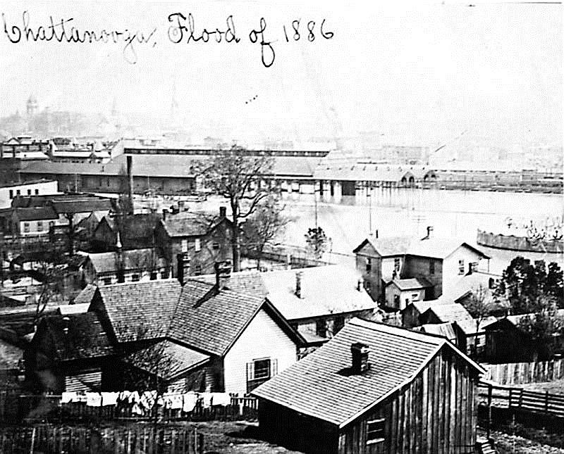
The iconic photograph published with this article shows a view of Chattanooga from Cameron Hill. Only the smokestacks of locomotives in the depot yard could be seen, and the water was five feet deep at the Union Depot across from the Crutchfield House. Steamboats actually came up Market Street as far as Fifth Street and could have gone further.
The flood waters traveled down the Tennessee River, causing inundation and damage all the way to the Ohio River.
In Chattanooga, no lives were lost, but merchants lost stock and inventory. Houses, barns and outbuildings were either destroyed or carried off their foundations to new locations. Freight at the depot was lost along with damage to the rolling stock and tracks.
The military bridge built by the Union army that connected Market Street with the north shore was washed away, except for one section. Its piers remained, however, for almost 50 years, until they were dynamited to make way for the current Market Street Bridge. Travel across the river was by ferry boat until the Walnut Street Bridge opened in 1891.
Chattanooga is susceptible to floods, as a large basin collects water that combines into the Tennessee River above Knoxville, joins with the streams (such as the Hiwassee River) that flow into it below that point, forming an almost fan-shaped collection area.
Then, immediately below the city, the river flows through the Tennessee River gorge, which contributes to water backing up toward the city. Floods are known to have occurred 17 times between 1791 and 1936. More recently, there have been floods of more than 30 feet five times since the 1973 event, the most significant of recent memory in May 2003.
Sam D. Elliott, of the law firm of Gearhiser, Peters, Elliott and Cannon, is the author or editor of several books and articles on Tennessee in the Civil War era, including a forthcoming biography of Gov. John C. Brown. For more, visit Chattahistoricalassoc.org.